| Chiricahua Mountains | |
|---|---|
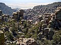
 Chiricahua Mountains – northeast flank (from Portal, Arizona) | |
| Highest point | |
| Peak | Chiricahua Peak |
| Elevation | 9,759 ft (2,975 m) |
| Coordinates | 31°50′47″N109°17′28″W / 31.84639°N 109.29111°W |
| Dimensions | |
| Length | 35 mi (56 km)NW, then SW |
| Width | 21 mi (34 km)(arc-shape)-N-S |
| Geography | |
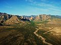
 Chiricahua Mountains Chiricahua Mountains in Arizona | |
| Country | United States |
| State | Arizona |
| Regions | |
| County | Cochise |
| Communities | |
| Range coordinates | 31°55′47″N109°22′56″W / 31.9298117°N 109.3822849°W |
| Borders on | |
The Chiricahua Mountains are a mountain range in southeastern Arizona and part of the Basin and Range province of the western and southwestern United States and northwestern Mexico. The range lies primarily within the Coronado National Forest. Chiricahua Peak, the highest point in the range, rises 9,759 feet (2,975 m) above sea level, about 6,000 feet (1,800 m) above the surrounding valleys. The mountains are named for the Chiricahua Apache, who historically lived in the region.


