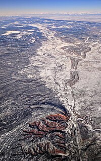
Rucker Canyon is a major canyon draining the western central-south of the Chiricahua Mountains, the central landform of the eastern third of Cochise County, Arizona's extreme southeast, bordering southwest New Mexico. It is famous for historic Camp Rucker.
The canyon contains Rucker Creek, (Rucker Wash), and upstream closer to the headwaters, the small Rucker Lake. The wash drains into the southern region of the slightly north-west by due south Sulphur Springs Valley, east of north–south running U.S. Route 191 and the small communities of Elfrida, McNeal, and Sunizona. The Rucker Wash drains westwards toward the Sulphur Springs Valley and borders the northern small Swisshelm Mountains traversing the named Whitewater Draw of Rucker Creek.
The Rucker Wash is near a water divide. The Swisshelm Mountains are adjacent the southern border of the Sulphur Springs Valley, with Rucker Wash draining north towards the Willcox Playa, and drainage south toward Douglas, Arizona and Mexico
Rucker Lake was destroyed by a landslide some years ago and no longer exists.
The Chiricahua Mountains massif is a large mountain range in southeastern Arizona which is part of the Basin and Range province of the west and southwestern United States and northwest Mexico; the range is part of the Coronado National Forest. The highest point, Chiricahua Peak, rises 9,759 feet (2,975 m) above sea level, approximately 6,000 feet (1,800 m) above the surrounding valleys. The range takes its name from the Chiricahua Apaches native to the region.
The Mohave Valley is a valley located mostly on the east shore of the south-flowing Colorado River in northwest Arizona. The valley extends into California's San Bernardino County; the northern side of the valley extends into extreme southeast Clark County, Nevada. The main part of the valley lies in southwest Mohave County, Arizona and is at the intersection of the southeast Mojave and northwest Sonoran deserts.
Middle Park is a high basin in the Rocky Mountains of north-central Colorado in the United States. It is located in Grand County, on the southwest slope of Rocky Mountain National Park, approximately 50 miles (80 km) west of Boulder.
The Sierra Ancha is a mountain range in Gila County, in central Arizona. It lies between Roosevelt Lake to the south, the Tonto Basin to the west, Cherry Creek to the east, and Pleasant Valley to the north. The range is one of several, including the Bradshaw Mountains, Mingus Mountain of the Black Hills, and the Mazatzal Mountains, which form a transitional zone between the lowland deserts of southern Arizona and the Colorado Plateau of northeastern Arizona. The highest point in the range is Aztec Peak, at an elevation of 2345 m (7694 ft).
The Mogollon Plateau or Mogollon Mesa is a pine-covered southern plateau section of the larger Colorado Plateau in east-central Arizona and west-central New Mexico, United States. The southern boundary of the plateau is the Mogollon Rim. The Mogollon Plateau is 7,000–8,000 feet (2,100–2,400 m) high. The plateau lends its name to the Mogollon tribe, part of the Cochise-Mogollan peoples who inhabited this and nearby areas from 5,000 to 2,500 years ago. Their descendants are believed to include the Anasazi.
The geography of the U.S. State of Colorado is diverse, encompassing both rugged mountainous terrain, vast plains, desert lands, desert canyons, and mesas. Colorado is a landlocked U.S. state. In 1861, the United States Congress defined the boundaries of the new Territory of Colorado exclusively by lines of latitude and longitude, stretching from 37°N to 41°N latitude, and from 102°02'48"W to 109°02'48"W longitude. Starting in 1868, official surveys demarcated the boundaries, deviating from the parallels and meridians in several places. Later surveys attempted to correct some of these mistakes but in 1925 the U.S. Supreme Court affirmed that the earlier demarcation was the official boundary. The borders of Colorado are now officially defined by 697 boundary markers connected by straight boundary lines. Colorado, Wyoming, and Utah are the only states that have their borders defined solely by straight boundary lines with no natural features. The southwest corner of Colorado is the Four Corners Monument at 36°59'56"N, 109°2'43"W. This is the only place in the United States where four states meet: Colorado, New Mexico, Arizona, and Utah.
Red Lake is a lake located next to Navajo, New Mexico, in the Red Valley in McKinley County, New Mexico, and Apache County, Arizona. The lake has a surface elevation of 7,150 ft (2,180 m). Navajo, New Mexico, lies on the southeast corner of the lake.
Temescal Creek is an approximately 29-mile-long (47 km) watercourse in Riverside County, in the U.S. state of California. Flowing primarily in a northwestern direction, it connects Lake Elsinore with the Santa Ana River. It drains the eastern slopes of the Santa Ana Mountains on its left and on its right the western slopes of the Temescal Mountains along its length. With a drainage basin of about 1,000 square miles (2,600 km2), it is the largest tributary of the Santa Ana River, hydrologically connecting the 720-square-mile (1,900 km2) San Jacinto River and Lake Elsinore watersheds to the rest of the Santa Ana watershed. However, flowing through an arid rain shadow zone of the Santa Ana Mountains, and with diversion of ground water for human use, the creek today is ephemeral for most of its length, except for runoff from housing developments and agricultural return flows.
The Sacramento Wash is a major drainage of northwest Arizona in Mohave County. The wash is east of the Black Canyon of the Colorado and drains into the south-flowing Colorado River 45 mi south of Lake Mohave, and 90 mi south of Hoover Dam at Lake Mead. The wash outfall is in the center-south of the Havasu-Mohave Lakes Watershed. An equivalent wash drains to the west of the Colorado River and the Black Canyon, draining southeast Nevada and a small part of California, the Piute Wash of the Piute Valley. The Piute Wash outfall is upstream of the Sacramento's outfall by about 15 miles.
The Sulphur Springs Valley is a valley in the eastern half of Cochise County, Arizona. The valley covers an approximated vertical rectangle west of the Chiricahua Mountains–Dos Cabezas Mountains complex. The Sulphur Springs Valley is the large flatland to the west.
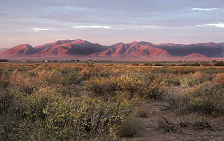
The Swisshelm Mountains are a small mountain range adjacent to the southwest corner of the Chiricahua Mountains of eastern Cochise County, Arizona. They are separated from the Pedrogosa Mountains to the southeast, the Chiricahuas to the northeast, and by Leslie Creek, bordering the south and east; the area is now notable for the Leslie Canyon National Wildlife Refuge.
The Little Rincon Mountains are a small range of mountains, lying to the east of the Rincon Mountains, at Tucson, of eastern Pima County, Arizona. The range is located in northwest Cochise County and is part of the western border of the San Pedro River and Valley, the major valley and river of western Cochise County. The river is northward flowing to meet the Gila River; its headwaters are south of the US-Mexico border in northern Sonora. A small part of the Little Rincon range's southwest lies in Pima County.
The Whitlock Valley is a small valley in southeast Graham County, Arizona, southwestern United States, lying between three mountain ranges. The valley lies on the south perimeter region of the White Mountains in eastern Arizona, and lies south of the west-flowing Gila River, and the region transitions south into Cochise County and three large valleys, with some scattered dry lakes. The valley is endorheic, with a small dry lake called Parks Lake, and merges southwest into the north of the San Simon Valley, where the San Simon River has its origins in the flatlands, and surrounding perimeter mountains. The valley was named after Captain James H. Whitlock who commanded during the Battle of Mount Gray in 1864 which was fought near the valley.
The Guadalupe Mountains of Hidalgo County are a 13 mi (21 km) long, sub–range in southwest Hidalgo County, New Mexico, adjacent the southeast border of Arizona's Cochise County. A small portion of the range is in Cochise County, namely the outlet of Guadalupe Canyon, famous for the Guadalupe Canyon Massacre. The very southern end of the range is also in the border region of Sonora, just north of Federal Highway 2.
The Colorado River is a major river of the western United States and northwest Mexico in North America. Its headwaters are in the Rocky Mountains where La Poudre Pass Lake is its source. Located in north central Colorado it flows southwest through the Colorado Plateau country of western Colorado, southeastern Utah and northwestern Arizona where it flows through the Grand Canyon. It turns south near Las Vegas, Nevada, forming the Arizona–Nevada border in Lake Mead and the Arizona–California border a few miles below Davis Dam between Laughlin, Nevada and Needles, California before entering Mexico in the Colorado Desert. Most of its waters are diverted into the Imperial Valley of Southern California. In Mexico its course forms the boundary between Sonora and Baja California before entering the Gulf of California. This article describes most of the major features along the river.
Chinle Valley is a 65-mile (105 km) long valley located mostly in Apache County Arizona. Chinle Creek continues north into Utah to meet the San Juan River (Utah).
Black Creek of Arizona is a 55-mi (89 km) long north tributary of the Puerco River, in northeast Arizona and northwest New Mexico.
The Defiance Plateau, part of the geologic Defiance Uplift, is an approximately 75-mile (121 km) long, mostly north-trending plateau of Apache County, Arizona, with its east and southeast perimeter, as parts of San Juan and McKinley Counties, New Mexico.
The Perris Block is the central block of three major fault-bounded blocks of the northern part of the Peninsular Ranges. The Perris Block lies between the Santa Ana Block to the west and the San Jacinto Block to the east. The Perris Block, was named by Walter A. English in 1925 for the city of Perris, located near the center of the block.
Whitewater Draw, originally Rio de Agua Prieta, [Spanish: river of dark water], is a tributary stream of the Rio de Agua Prieta in Cochise County, Arizona. It was called Blackwater Creek by Philip St. George Cooke when his command, the Mormon Battalion, camped at a spring on its course on December 5, 1846.
This page is based on this Wikipedia article Text is available under the CC BY-SA 4.0 license; additional terms may apply. Images, videos and audio are available under their respective licenses.