Related Research Articles
Tumbez, Virginia, is a small cluster of homes and farms at a fork in the road in the southwestern edge of Russell County in the U.S. state of Virginia. It was the home of mountain music fiddler Uncle Charlie Osborne.
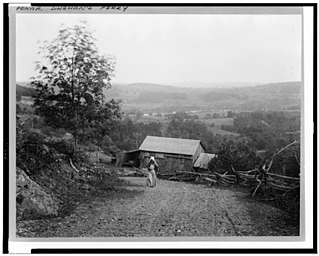
Dingmans Ferry is an unincorporated community in Delaware Township, Pike County, Pennsylvania, United States. As of 2014, it had a population of just over 1,000 people. It was originally sited on the Delaware River, in an area now included in the Delaware Water Gap National Recreation Area. When the Corps of Engineers acquired the land by eminent domain in the mid-twentieth century for the creation of the proposed Tocks Island Dam project, it relocated the community further up the hill.
The Tule Desert is a small desert located in southwestern Arizona near the U.S.-Mexico border. It is considered to be part of the Lower Colorado Valley region of the Sonoran Desert. It lies in a north–south direction to the east of the Cabeza Prieta Mountains and almost entirely in the Barry M. Goldwater Air Force Range. The Tule Desert also lies on the northern border of the Gran Desierto de Altar of Sonora, Mexico.
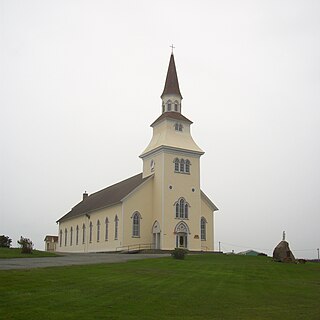
Saulnierville is a rural Acadian fishing community founded in 1785, located in Nova Scotia, Canada. It contains the French Shore's largest fish processing plant, Comeau Sea Foods, which has been in operations since 1946. Saulnierville also has one of the oldest churches in the region, Sacré Cœur Church, built in 1880. The Clare Municipality Veterans Centre in Saulnierville is the starting point of the Gran Fondo Baie Sainte-Marie, a mass-start cycling ride in late September. It is located in Digby County.
Pittsburg is an unincorporated community in Fayette County, Illinois, United States. Located at 38°52′17″N89°12′42″W, it lies at an elevation of 531 feet. It was named after the industrial heritage of Pittsburgh, Pennsylvania which, coincidentally, has a Fayette County, Pennsylvania as part of its metropolitan area.
The Elm Fork Red River is a river in Oklahoma. It flows into the North Fork of the Red River near Quartz Mountain State Park, about ten miles east of Mangum, Oklahoma.
The L Streets is a neighborhood in the Lake Highlands area of Dallas, Texas (USA). It is generally bounded by Ferndale Road on the west, Northwest Highway on the south, Plano Road on the east and Kingsley/Walnut Hill on the north. However, it excludes commercial property on its southwest and southeast corners, apartments along Northwest Highway and a church on its northeast corner.
The Whitefish River is an 11.9-mile-long (19.2 km) river on the Upper Peninsula of the U.S. state of Michigan. The mouth of the river is in Delta County at 45°54′34″N86°58′01″W on the Little Bay De Noc of Lake Michigan. The main branch of the river is formed by the confluence of the east and west branches at 46°03′25″N86°52′17″W.
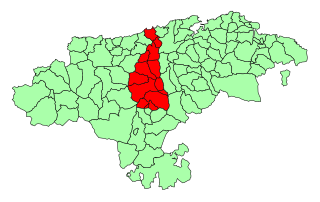
The Besaya valley is both a comarca located in the center of Cantabria, along the course of the Besaya River, and the natural valley of said river. Its capital is Torrelavega.
Reinland is a Mennonite village in Manitoba located in the Rural Municipality of Stanley, about ten minutes south of Winkler and about five minutes north of U.S. border. Its population numbers about five hundred, with an agrarian economy.
The Tule Mountains is a mountain range in Yuma County, Arizona. There is a diverse flora and fauna population within the Tule Mountains; one of the notable trees found in this mountain range is the elephant tree.
Hassengers Corner is an unincorporated community at the intersection of Maryland Route 213 and Maryland Route 561 in Kent County, Maryland, United States.

Rotgundspitze is a mountain of Bavaria, Germany. It is located in the main ridge of the Allgäu Alps mountain range.
Clare is an unincorporated community in Johnson County, Kansas, United States, and part of the Kansas City metropolitan area. It is located at 38°49′37″N94°52′17″W.
Ocheltree is an unincorporated community in Johnson County, Kansas, United States, and part of the Kansas City metropolitan area.
Book is an unincorporated community in Catahoula Parish, Louisiana, United States.
Crown Hill is a ghost town in Lawrence County, in the U.S. state of South Dakota.
Omar is an unincorporated community in Seneca County, in the U.S. state of Ohio.
Sweetwater is an unincorporated community in Newton County, in the U.S. state of Missouri. The community is located at the intersection of Missouri routes H and HH approximately five miles southeast of Neosho. Aroma is 2.5 miles north and Boulder City lies two miles southeast on Route H.
Helena is an unincorporated community in Tensas Parish, Louisiana, United States.
References
32°15′57″N113°52′17″W / 32.26583°N 113.87139°W
| | This Yuma County, Arizona location article is a stub. You can help Wikipedia by expanding it. |
| | This article related to a mountain, mountain range, or peak in the United States is a stub. You can help Wikipedia by expanding it. |