Sierra Vista is a city in Cochise County, Arizona, United States. According to the 2020 Census, the population of the city is 45,308, and is the 27th most populous city in Arizona. The city is part of the Sierra Vista-Douglas Metropolitan Area, with a 2010 population of 131,346. Fort Huachuca, a U.S. Army post, has been incorporated and is located in the northwest part of the city. Sierra Vista is bordered by the cities of Huachuca City and Whetstone to the north and Sierra Vista Southeast to the South.
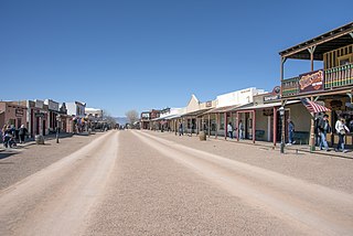
Tombstone is a city in Cochise County, Arizona, United States, founded in 1879 by prospector Ed Schieffelin in what was then Pima County, Arizona Territory. It became one of the last boomtowns in the American frontier. The town grew significantly into the mid-1880s as the local mines produced $40 to $85 million in silver bullion, the largest productive silver district in Arizona. Its population grew from 100 to around 14,000 in less than seven years. It is best known as the site of the Gunfight at the O.K. Corral and presently draws most of its revenue from tourism.

Grand Canyon Village is a census-designated place (CDP) located on the South Rim of the Grand Canyon, in Coconino County, Arizona, United States. Its population was 2,004 at the 2010 Census. Located in Grand Canyon National Park, it is wholly focused on accommodating tourists visiting the canyon. Its origins trace back to the railroad completed from Williams, to the canyon's South Rim by the Santa Fe Railroad in 1901. Many of the structures in use today date from that period. The village contains numerous landmark buildings, and its historic core is a National Historic Landmark District, designated for its outstanding implementation of town design.

Young is an unincorporated community and census-designated place (CDP) in Gila County, Arizona, United States. The population was 588 as of the 2020 census.

Angelus Oaks is an unincorporated community in San Bernardino County, California, United States, and has a population of 535 as of the 2010 U.S. Census, up from an estimated population of 312 in 2000. It is surrounded by the San Bernardino National Forest and located east of San Bernardino on California State Route 38.
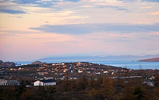
Bay Roberts is a town located on the north shore of Conception Bay on the northeastern Avalon Peninsula in the province of Newfoundland and Labrador, Canada. The growth of the local economy can be connected to the town's proximity to other major Newfoundland markets, by road and by water.
Hereford is a populated place in Cochise County along the San Pedro Riparian National Conservation Area in the southern part of the U.S. state of Arizona. It is southeast of Sierra Vista and is a part of the Sierra Vista-Douglas micropolitan area. The elevation is 4,193 feet at the location of the original townsite at the far eastern end of the unincorporated area; the residential area runs for another 8 miles west from this location, blending into the unincorporated area of Nicksville at an elevation of approximately 4800 feet. Hereford Station Post Office is located at the far western end of Nicksville, at the foot of the Huachuca Mountains.
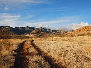
Galiuro Wilderness is a 76,317-acre (309 km2) wilderness area encompassing the mid to upper slopes of the Galiuro Mountains. It is located within the Safford Ranger District of the Coronado National Forest in the American state of Arizona. It is bordered on the south by the Redfield Canyon Wilderness.

Alamo Crossing is a ghost town in Mohave County, Arizona, United States. The town was settled in the late 1890s, in what was then the Arizona Territory. It served as a camp for mining prospectors in the manganese-rich Artillery Mountains, being the only town in the area. After 1918, the post office permanently closed, but the town was only intermittently abandoned, with its founders often present through until at least the mid-1950s. The town was intentionally flooded in 1968 to create Alamo Lake. In 2020, the area of Alamo was revived for mining again, this time for surface-level gold prospecting.

Aravaipa Creek is a drainage between three mountain ranges in southwest Graham County, Arizona – the Galiuro Mountains, the Santa Teresa Mountains and the Pinaleno Mountains. These mountains are part of the high altitude Madrean Sky Islands located in southern Arizona and New Mexico in the United States, and northern Sonora and Chihuahua states in Mexico.
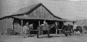
The Ruby Murders is the popular name for three separate incidents involving the deaths of six American citizens near the town of Ruby, Arizona. The first incident occurred in February 1920 when Mexican bandits robbed and killed the two owners of the Ruby Mercantile. A second attack happened in April 1921 when Mexican bandits robbed and killed the store's new owners. Two of the bandits were arrested for the crime, but they briefly escaped custody in July 1922 after killing another two men, which led to the largest manhunt in the history of the Southwest.

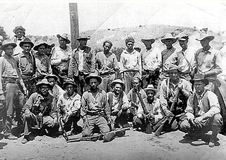
The Power's Cabin shootout, or the Power Brothers shootout, occurred on February 10, 1918, when a posse attempted to arrest a group of miners at their cabin in the Galiuro Mountains. Four men were killed during the shootout, including three lawmen and Jeff Power, the owner of the cabin. The Power brothers, Tom and John, then escaped to Mexico with a man named Tom Sisson, but they were eventually caught after what was then the largest manhunt in the history of Arizona.

Silver Bell is a ghost town in the Silver Bell Mountains in Pima County, Arizona, United States. The name "Silver Bell" refers to a more recent ghost town, which was established in 1954 and abandoned in 1984. The original town, established in 1904, was named "Silverbell" and abandoned in the early 1930s. Both towns were utilized and later abandoned due to the mining of copper in the area.

Pantano is a ghost town located in eastern Pima County, Arizona, between Benson and Vail. Access is via the Marsh Station Road interchange on I-10. It was established as a small railroad town with the arrival of the Southern Pacific in 1880, supplanting the earlier Ciénega station that was located to the west of Pantano.

La Casa del High Jinks is a historic house located on High Jinks Ranch in Pinal County, Arizona, southeast of the community of Oracle. The ranch was founded in 1912 by Buffalo Bill Cody, who ran a gold mine at the site. After Cody's death, the ranch was seized for unpaid taxes and subsequently sold to Lewis Claude Way. Way built the Pueblo style ranch house on the property, which he completed in 1928. The house is listed on the National Register of Historic Places.
Tuff is a ghost town in Bandera County, in the U.S. state of Texas, in the Texas Hill Country, which is part of the Edwards Plateau. It is considered part of the San Antonio Metropolitan Statistical Area.