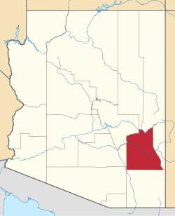
Thatcher, Arizona

Last updated
Thatcher, Arizona
Thatcher-Spencer W. Kimball Childhood Home-1902.jpg
Spencer W. Kimball Childhood Home Marker
Graham County Arizona Incorporated and Unincorporated areas Thatcher Highlighted 0473420.svg
Location of Thatcher in Graham County, Arizona
Usa edcp location map.svg
Red pog.svg
Thatcher, Arizona
Location in the United States
Coordinates: 32°49′58″N109°45′46″W / 32.83278°N 109.76278°W / 32.83278; -109.76278
Country United States
State Arizona
County Graham
Government
  TypeIncorporated Town
   Mayor Randy Bryce [1]
   Vice Mayor Jenny Howard
   Town Council Eddy Carlton, Mike McEuen, Ashley Smith, Mark Vining, Heston Welker
   Town Manager Heath Brown
Area
[2]
  Total6.62 sq mi (17.14 km2)
  Land6.60 sq mi (17.10 km2)
  Water0.02 sq mi (0.04 km2)
Elevation
2,910 ft (887 m)
Population
 (2020)
  Total5,231
  Density792.22/sq mi (305.86/km2)
Time zone UTC-7 (MST (no DST))
ZIP code
85552
Area code 928
FIPS code 04-73420
GNIS feature ID 12277
Website Town of Thatcher

Thatcher is a town in Graham County, Arizona, United States. According to the 2010 Census, the population of the town is 4,865. [3] It is part of the Safford Micropolitan Statistical Area.

Contents

Thatcher is the home of Eastern Arizona College (EAC), a college that offers two year degrees and includes a nursing school. [4]

Geography

Thatcher is located at 32°49′58″N109°45′46″W / 32.83278°N 109.76278°W / 32.83278; -109.76278 (32.832685, −109.762879). [5]

The town is centered in the Upper Gila River Valley with one of Arizona's famous Madrean Sky Islands towering to the south and the Gila River to the north.

According to the United States Census Bureau, the town has a total area of 6.7 square miles (17 km2), including 0.02 square miles (0.052 km2) of water.

Demographics

Historical population
CensusPop.Note
1890 320
1900 644101.3%
1910 90440.4%
1920 899−0.6%
1930 895−0.4%
1940 1,10623.6%
1950 1,28416.1%
1960 1,58123.1%
1970 2,32046.7%
1980 3,37445.4%
1990 3,76311.5%
2000 4,0226.9%
2010 4,86521.0%
2020 5,2317.5%
U.S. Decennial Census [6]

As of the census [7] of 2000, there were 4,022 people, 1,281 households, and 927 families residing in the town. The population density was 919.4 inhabitants per square mile (355.0/km2). There were 1,427 housing units at an average density of 326.2 per square mile (125.9/km2). The racial makeup of the town was 84.7% White, 0.8% Black or African American, 1.8% Native American, 0.5% Asian, 0.1% Pacific Islander, 9.9% from other races, and 2.2% from two or more races. 19.5% of the population were Hispanic or Latino of any race.

There were 1,281 households, out of which 36.3% had children under the age of 18 living with them, 59.3% were married couples living together, 9.9% had a female householder with no husband present, and 27.6% were non-families. 19.7% of all households were made up of individuals, and 10.5% had someone living alone who was 65 years of age or older. The average household size was 2.94 and the average family size was 3.37.

In the town, the population was spread out, with 27.6% under the age of 18, 22.8% from 18 to 24, 18.9% from 25 to 44, 18.3% from 45 to 64, and 12.4% who were 65 years of age or older. The median age was 25 years. For every 100 females, there were 87.9 males. For every 100 females age 18 and over, there were 83.5 males.

The median income for a household in the town was $32,412, and the median income for a family was $40,392. Males had a median income of $35,815 versus $20,964 for females. The per capita income for the town was $12,961. 17.2% of the population lives below the poverty line. [8]

Emergency response

Emergency 911 services are provided by the 24/7 dispatch center of the Graham County Sheriff's Office. Fire services are provided by the all volunteer Thatcher Fire Department, which has the capability to respond with various types of equipment, including several fire engines and a ladder truck. Mount Graham Regional Medical Center is the medical services provider for the area.

The Thatcher Police Department (TPD) is the municipal law enforcement agency responsible for policing the town. [9] It has an approximately 10-man uniformed division.

Thatcher Police Crown Victoria Police Interceptor in Safford, Arizona. Thatcherpolicecar.jpg
Thatcher Police Crown Victoria Police Interceptor in Safford, Arizona.

History

Thatcher was originally settled by members of the Church of Jesus Christ of Latter-day Saints. The first settler was John M. Moody who arrived in Thatcher with his wife and children in 1881. [10] The founding of Thatcher is attributed to Mormon pioneer Christopher Layton, who bought two thousand acres, named the acreage "Thatcher", divided them into lots, and sold those lots to Mormon settlers. Layton also bought a gristmill and built roads, canals and homes.

Eastern Arizona College traces its history to the St. Joseph Stake Academy started by the church in nearby Central. Central is also the location of the Gila Valley Arizona Temple.

Transportation

San Carlos Apache Nnee Bich'o Nii Transit provides transportation from Thatcher to the San Carlos Apache Indian Reservation, Safford and Globe. [11] Greyhound Lines serves Thatcher on its PhoenixEl Paso via Globe route.

The Arizona Eastern Railway operates rail freight through town on a branch formerly operated by the Southern Pacific. Traffic is primarily copper products on the route between Bowie and Miami, AZ.

Notable people

Historic Brinkeroff Hotel and Spencer W. Kimball Childhood Home

See also

Related Research Articles

<span class="mw-page-title-main">Gila County, Arizona</span> County in Arizona, United States

Gila County is in the central part of the U.S. state of Arizona. As of the 2020 census, the population was 53,272. The county seat is Globe.

<span class="mw-page-title-main">Graham County, Arizona</span> County in Arizona, United States

Graham County is a county in the southeastern part of the U.S. state of Arizona. As of the 2020 census, the population was 38,533, making it the third-least populous county in Arizona. The county seat is Safford.

<span class="mw-page-title-main">Greenlee County, Arizona</span> County in Arizona, United States

Greenlee County is a county in the southeastern part of the U.S. state of Arizona. As of the 2020 census, the population was 9,563, making it Arizona's least populous county. The county seat is Clifton.

<span class="mw-page-title-main">Pinal County, Arizona</span> County in Arizona, United States

Pinal County is in the central part of the U.S. state of Arizona. According to the 2020 census, the population of the county was 425,264, making it Arizona's third-most populous county. The county seat is Florence. The county was founded in 1875.

<span class="mw-page-title-main">Globe, Arizona</span> City in Arizona, United States

Globe is a city in Gila County, Arizona, United States. As of the 2020 census, the population of the city was 7,249. The city is the county seat of Gila County. Globe was founded c. 1875 as a mining camp. Mining, tourism, government and retirees are most important in the present-day Globe economy.

<span class="mw-page-title-main">Hayden, Arizona</span> Town in Gila and Pinal Counties, Arizona

Hayden is a town in Gila and Pinal counties in Arizona, United States. According to the 2010 census, the population of the town was 662.

<span class="mw-page-title-main">Peridot, Arizona</span> CDP in Gila and Graham Counties, Arizona, US

Peridot is an unincorporated community and census-designated place (CDP) in Gila and Graham counties in the U.S. state of Arizona. The population was 1,350 at the 2010 census.

<span class="mw-page-title-main">Pine, Arizona</span> CDP in Gila County, Arizona

Pine is an unincorporated community and census-designated place (CDP) in Gila County, Arizona, United States. The population was 1,963 at the 2010 census. Pine was established by four Mormon families in 1879.

<span class="mw-page-title-main">San Carlos, Arizona</span> CDP in Gila County, Arizona

San Carlos is a census-designated place (CDP) in Gila County, Arizona, United States. The population was 4,038 at the 2010 census, up from 3,716 in 2000.

<span class="mw-page-title-main">Winkelman, Arizona</span> Town in Gila and Pinal Counties, Arizona

Winkelman is a town in Gila and Pinal counties in Arizona, United States. According to the 2010 census, the population of the town was 353, all of whom lived in Gila County.

<span class="mw-page-title-main">Pima, Arizona</span> Town in Graham County, Arizona

Pima is a town in Graham County, Arizona, United States. As of the 2010 census, the population of the town was 2,387, up from 1,989 in 2000. The estimated population in 2018 was 2,512. Pima is part of the Safford Micropolitan Statistical Area.

<span class="mw-page-title-main">Safford, Arizona</span> City in Arizona, United States

Safford is a city in Graham County, Arizona, United States. According to the 2020 Census, the population of the city is 10,129. The city is the county seat of Graham County.

<span class="mw-page-title-main">Swift Trail Junction, Arizona</span> CDP in Graham County, Arizona

Swift Trail Junction is a census-designated place (CDP) in Graham County, Arizona, United States. The population was 2,935 at the 2010 census, up from 2,195 in 2000. It is part of the Safford Micropolitan Statistical Area. It is situated at the junction of U.S. Route 191 and State Route 366. The Swift Trail Parkway is a scenic highway that winds through the Coronado National Forest and provides access to the higher elevations of the Pinaleño Mountains, also known as the Graham Mountains.

<span class="mw-page-title-main">Duncan, Arizona</span> Town in Greenlee County, Arizona

Duncan is a town in Greenlee County, Arizona, United States. As of the 2010 census, the population of the town was 696. In 2018 the estimated population was 789.

<span class="mw-page-title-main">Gila Bend, Arizona</span> Town in Maricopa County, Arizona

Gila Bend, founded in 1872, is a town in Maricopa County, Arizona, United States. The town is named for an approximately 90-degree bend in the Gila River, which is near the community's current location. As of the 2020 census, the population of the town was 1,892.

<span class="mw-page-title-main">Sacaton, Arizona</span> CDP in Pinal County, Arizona

Sacaton is a census-designated place (CDP) in Pinal County, Arizona, United States. The population was 3,254 at the 2020 census. It is the capital of the Gila River Indian Community.

<span class="mw-page-title-main">Eastern Arizona College</span> Community college in Graham County, Arizona

Eastern Arizona College (EAC), is a community college in Graham County, Arizona. The main campus is in Thatcher, with satellite locations in Gila County and Greenlee County. It is the oldest community college in Arizona and the only one in the state with a marching band.

<span class="mw-page-title-main">Central, Arizona</span> CDP in Graham County, Arizona

Central is a census-designated place in Graham County, Arizona, United States. Its population was 758 as of the 2020 census. It is part of the Safford micropolitan area.

<span class="mw-page-title-main">Safford, Arizona micropolitan area</span> US Census Bureau statistical area (μSA)

The Safford Micropolitan Statistical Area, as defined by the United States Census Bureau, is a micropolitan statistical area (μSA) consisting of one county in eastern Arizona, anchored by the city of Safford.

<span class="mw-page-title-main">Bylas, Arizona</span> CDP in Graham County, Arizona

Bylas is an unincorporated community and census-designated place in Graham County, Arizona, United States, located within the San Carlos Apache Indian Reservation. As of the 2010 census, its population was 1,962. The community has a medical clinic, a police substation, and a market. Bylas is an Apache settlement divided into two communities, one of the White Mountain Apache, the other of San Carlos and Southern Tonto Apache. It is named for Bylas a chief of the Eastern White Mountain Apache band.

References

  1. Office and Contact Information, Thatcher. Accessed 2024-01-13.
  2. "2020 U.S. Gazetteer Files". United States Census Bureau. Retrieved October 29, 2021.
  3. "U.S. Census website". United States Census Bureau . Retrieved 2014-08-23.
  4. "Home". www.eac.edu.
  5. "US Gazetteer files: 2010, 2000, and 1990". United States Census Bureau. 2011-02-12. Retrieved 2011-04-23.
  6. "Census of Population and Housing". Census.gov. Retrieved June 4, 2016.
  7. "U.S. Census website". United States Census Bureau . Retrieved 2008-01-31.
  8. "U.S. Census Bureau QuickFacts: Thatcher town, Arizona; Graham County, Arizona; Arizona". www.census.gov. Retrieved 2018-04-16.
  9. "Thatcher, Arizona - Facilities". Archived from the original on September 27, 2008.
  10. Andrew Jenson. Encyclopedic History of the Church. (Salt Lake City: Deseret News Press, 1941) p. 870. accessed via infobase CD library
  11. "Globe/Safford Route". Nnee Bich'o Nii Transit. Retrieved 2020-01-27.
  12. Saunders, Diane (February 21, 2011). "Former Valley resident wins visual effects award". Eastern Arizona Courier.
  13. "Jacque Mercer Collection 1922-1971 Mercer, (Jacque) Collection". www.azarchivesonline.org.