
Burnside is a native village and census-designated place (CDP) on the Navajo Nation in Apache County, Arizona, United States. The population was 537 at the 2010 census.

Bitter Springs is a native village and census-designated place (CDP) on the Navajo Nation in Coconino County, Arizona, United States. As of the 2020 census, the CDP population was 364

Swift Trail Junction is a census-designated place (CDP) in Graham County, Arizona, United States. The population was 2,935 at the 2010 census, up from 2,195 in 2000. It is part of the Safford Micropolitan Statistical Area. It is situated at the junction of U.S. Route 191 and State Route 366. The Swift Trail Parkway is a scenic highway that winds through the Coronado National Forest and provides access to the higher elevations of the Pinaleño Mountains.

Bouse is a census-designated place (CDP) and ghost town in La Paz County, Arizona, United States. Founded in 1908 as a mining camp, the economy of Bouse is now based on tourism, agriculture, and retirees. The population was 996 at the 2010 census. It was originally named Brayton after the store owner John Brayton Martin.

Aguila is an unincorporated community and census-designated place (CDP) in Maricopa County, Arizona, United States. It is located on U.S. Route 60, 25 miles (40 km) west of Wickenburg and 22 miles (35 km) northeast of Wenden. Major economic activities include cantaloupe farming and formerly included mining. It uses the same street numbering system as Phoenix. As of the 2020 census, the population of Aguila was 565, down from 798 in 2010.

Arlington is an unincorporated community and census-designated place (CDP) in Maricopa County, Arizona, United States, located 43 miles (69 km) west of downtown Phoenix on old U.S 80. It follows the street numbering system of Phoenix. As of the 2020 census, the population was 150, down from 194 at the 2010 census.

Rio Rico is an unincorporated community and census-designated place (CDP) in Santa Cruz County, Arizona, United States. The population was 18,962 at the 2010 census. The Rio Rico CDP replaced the former CDPs of Rio Rico Northwest, Rio Rico Northeast, Rio Rico Southwest, and Rio Rico Southeast.

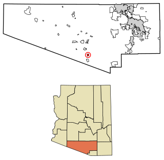
Brenda is a census-designated place (CDP) in La Paz County, Arizona, United States.

Bylas is an unincorporated community and census-designated place in Graham County, Arizona, United States, located within the San Carlos Apache Indian Reservation. As of the 2010 census, its population was 1,962. The community has a medical clinic, a police substation, and a market. Bylas is an Apache settlement divided into two communities, one of the White Mountain Apache, the other of San Carlos and Southern Tonto Apache. It is named for Bylas a chief of the Eastern White Mountain Apache band.

Cactus Forest is a census-designated place (CDP) in Pinal County, Arizona, United States. The population was 594 at the 2010 census.

Sacaton Flats Village is a census-designated place (CDP) in Pinal County, Arizona, United States, located in the Gila River Indian Community. The population was 621 at the 2010 census.
Beyerville is a census-designated place (CDP) in Santa Cruz County, Arizona, United States. The population was 177 at the 2010 census.

Bryce is a census-designated place in Graham County, Arizona, United States. Its population was 173 as of the 2020 census.

Bear Flat is a census-designated place (CDP) in Gila County, Arizona, United States. Bear Flat is located in the valley of Tonto Creek, 18 miles (29 km) east of the town of Payson. The population as of the 2010 census was 18.

Beaver Valley is a census-designated place in Gila County in the state of Arizona. Beaver Valley is located about 10 miles north of the town of Payson. The population, as of the 2010 U.S. Census, was 231.

Ak Chin, is a rural native village and a census-designated place on the Tohono Oʼodham Reservation, in Pima County, Arizona, United States. It had a population of 30 as of the 2010 U.S. Census and an estimated population of 31 as of July 1, 2015. Ak Chin has an estimated elevation of 1,854 feet (565 m) above sea level.
Chiawuli Tak is both a census-designated place (CDP) as well as a populated place in Pima County, Arizona, United States. Chiawuli Tak means "the barrel cactus sits" in the O'odham language. It is also unofficially known as Geowic, Jeowic, or Tjeavolitak. The population was 78 at the 2010 census.
South Komelik (O'odham) name translates as "South Flat", is a census-designated place in Pima County, in the U.S. state of Arizona. The population was 117 as of the 2020 census. It's located in the southern part of the Tohono O'odham Nation reservation near the border with Mexico.

Ventana is a census-designated place in Pima County, in the U.S. state of Arizona. The population was 52 at the 2020 census. The place takes it name from the Spanish word for "window" and is located in the northeastern part of the Tohono O'odham Nation reservation.

Willow Canyon is a census-designated place in Pima County, in the U.S. state of Arizona. The population was "S" (Seasonal) at the 2010 census.


