Swift Trail Junction, Arizona | |
---|---|
Coordinates: 32°43′48″N109°42′50″W / 32.73000°N 109.71389°W | |
Country | United States |
State | Arizona |
County | Graham |
Area | |
• Total | 3.72 sq mi (9.63 km2) |
• Land | 3.68 sq mi (9.54 km2) |
• Water | 0.03 sq mi (0.09 km2) |
Elevation | 3,232 ft (985 m) |
Population (2020) | |
• Total | 2,810 |
• Density | 762.76/sq mi (294.50/km2) |
Time zone | UTC-7 (MST (no DST)) |
ZIP code | 85546 [2] |
Area code | 928 |
FIPS code | 04-71650 |
GNIS feature ID | 0024638 |
Swift Trail Junction is a census-designated place (CDP) in Graham County, Arizona, United States. The population was 2,935 at the 2010 census, [3] up from 2,195 in 2000. It is part of the Safford Micropolitan Statistical Area. It is situated at the junction of U.S. Route 191 and State Route 366 (also known as the Swift Trail Parkway). The Swift Trail Parkway is a scenic highway that winds through the Coronado National Forest and provides access to the higher elevations of the Pinaleño Mountains, also known as the Graham Mountains.
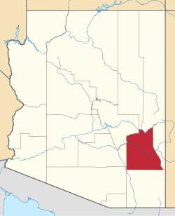
Swift Trail Junction is located in south-central Graham County at 32°44′5″N109°42′54″W / 32.73472°N 109.71500°W (32.734604, -109.714970) [4] at the base of the Pinaleno Mountains. It is bordered to the north by the Cactus Flats CDP. The junction at the center of the CDP is between U.S. Route 191, which leads north 7 miles (11 km) to Safford, the county seat, and south 26 miles (42 km) to Interstate 10, and Arizona State Route 366, which leads southwest 28 miles (45 km) up into the heart of the Pinaleno Mountains.
According to the United States Census Bureau, the Swift Trail Junction CDP has a total area of 3.7 square miles (9.6 km2), of which 3.7 square miles (9.5 km2) is land and 0.04 square miles (0.1 km2), or 0.9%, is water. [3] Federal Correctional Institution, Safford, a low-security federal prison for male inmates, is located in the southwest corner of the CDP.
Census | Pop. | Note | %± |
---|---|---|---|
2020 | 2,810 | — | |
U.S. Decennial Census [5] |
As of the census [6] of 2000, there were 2,195 people, 499 households, and 349 families residing in the CDP. The population density was 465.2 inhabitants per square mile (179.6/km2). There were 561 housing units at an average density of 118.9 per square mile (45.9/km2). The racial makeup of the CDP was 77.7% White, 5.8% Black or African American, 6.1% Native American, 2.2% Asian, 0.1% Pacific Islander, 7.2% from other races, and 1.0% from two or more races. 28.4% of the population were Hispanic or Latino of any race.
There were 499 households, out of which 33.9% had children under the age of 18 living with them, 56.9% were married couples living together, 8.8% had a female householder with no husband present, and 29.9% were non-families. 24.6% of all households were made up of individuals, and 9.4% had someone living alone who was 65 years of age or older. The average household size was 2.56 and the average family size was 3.07.
In the CDP, the population was spread out, with 16.1% under the age of 18, 10.2% from 18 to 24, 43.6% from 25 to 44, 20.7% from 45 to 64, and 9.3% who were 65 years of age or older. The median age was 35 years. For every 100 females, there were 236.1 males. For every 100 females age 18 and over, there were 285.4 males.
The median income for a household in the CDP was $28,393, and the median income for a family was $29,762. Males had a median income of $14,901 versus $18,750 for females. The per capita income for the CDP was $11,731. About 10.4% of families and 13.8% of the population were below the poverty line, including 7.4% of those under age 18 and 22.5% of those age 65 or over.
Graham County is a county in the southeastern part of the U.S. state of Arizona. As of the 2020 census, the population was 38,533, making it the third-least populous county in Arizona. The county seat is Safford.
Big Delta is a census-designated place (CDP) in Southeast Fairbanks Census Area, Alaska, United States. The population was 591 at the 2010 census, down from 749 in 2000. Big Delta is at the confluence of the Delta River and the Tanana River and gets its name from the huge river delta formed by the confluence.
Nelchina is a census-designated place (CDP) in Copper River Census Area, Alaska, United States. The population was 45 at the 2020 census, down from 59 in 2010.
Peridot is an unincorporated community and census-designated place (CDP) in Gila and Graham counties in the U.S. state of Arizona. The population was 1,350 at the 2010 census.
San Carlos is a census-designated place (CDP) in Gila County, Arizona, United States. The population was 4,038 at the 2010 census, up from 3,716 in 2000.
Pima is a town in Graham County, Arizona, United States. As of the 2010 census, the population of the town was 2,387, up from 1,989 in 2000. The estimated population in 2018 was 2,512. Pima is part of the Safford Micropolitan Statistical Area.
Safford is a city in Graham County, Arizona, United States. According to the 2020 Census, the population of the city is 10,129. The city is the county seat of Graham County.
Three Points is a census-designated place (CDP) in Pima County, Arizona, United States. The population was 5,581 at the 2010 census.
Queen Valley is a census-designated place (CDP) in north central Pinal County, Arizona, United States. The population was 820 at the 2000 census.
Clinton is a census-designated place (CDP) in Missoula County, Montana, United States. It is part of the 'Missoula, Montana Metropolitan Statistical Area'. The CDP was named for General Sir Henry Clinton. The population was 1,052 at the 2010 census, an increase from its population of 549 in 2000.
Silver Springs is a census-designated place (CDP) in Lyon County, Nevada, United States at the intersection of US 50 and US 95A. The population was 5,296 at the 2010 census. Lahontan Reservoir, Lahontan State Recreation Area and historic Fort Churchill State Historic Park are all located nearby. The area is served by the Silver Springs Airport.
Clintondale is a hamlet in Ulster County, New York, United States. The population was 1,938 at the 2020 census.
Summerside is a census-designated place (CDP) in Union Township, Clermont County, Ohio, United States. Its population was 4,941 as of the 2020 census.
Amity Gardens is a census-designated place (CDP) in Amity Township, Berks County, Pennsylvania. As of the 2020 census, the CDP had a total population of 3,715. The town lends its name to a Fountains of Wayne song.
Coburn is a census-designated place (CDP) in Centre County, Pennsylvania, United States. It is part of the State College, Pennsylvania Metropolitan Statistical Area. The population was 236 at the 2010 census.
Monarch Mill is a census-designated place (CDP) in Union County, South Carolina, United States. The population was 1,811 at the 2010 census.
Ocean City is a census-designated place (CDP) in Grays Harbor County, Washington, United States. The population was 200 at the 2010 census.
Amenia is a hamlet and census-designated place (CDP) in Dutchess County, New York, United States. The population was 725 at the 2020 census. It is part of the Poughkeepsie–Newburgh–Middletown, NY Metropolitan Statistical Area as well as the larger New York–Newark–Bridgeport, NY-NJ-CT-PA Combined Statistical Area.
Cambridge is a town in Lamoille County, Vermont, United States. The population was 3,839 at the 2020 United States Census. Cambridge includes the villages of Jeffersonville and Cambridge.
Skowhegan is a census-designated place (CDP) in the town of Skowhegan in Somerset County, Maine, United States. The population was 6,404 at the 2020 census.