
Graham County is a county in the southeastern part of the U.S. state of Arizona. As of the 2020 census, the population was 38,533, making it the third-least populous county in Arizona. The county seat is Safford.
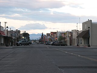
Safford is a city in Graham County, Arizona, United States. According to the 2020 Census, the population of the city is 10,129. The city is the county seat of Graham County.

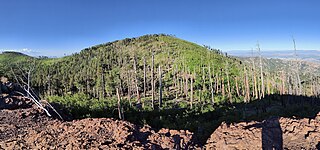
Mount Graham is a mountain in Graham County, Arizona, United States, approximately 70 miles (110 km) northeast of Tucson. The mountain reaches 10,724 feet (3,269 m) in height. It is the highest elevation in Graham County, Coronado National Forest and the Pinaleño Mountains. It is also the southernmost peak and land area in the continental United States above 10,000 feet (3,048 m). As the name "Mount Graham" is often used by locals to refer to the entire mountain range, the peak itself is frequently referred to as "High Peak". It is twentieth of the 57 ultra-prominent peaks of the lower 48 states, and the first of the five in Arizona.
This is a directory of properties and districts listed on the National Register of Historic Places in Arizona. There are 1,491 listed sites in the state, and each of its fifteen counties has at least ten listings on the National Register. Forty-seven of the state's sites are further designated as National Historic Landmarks.

The Pleasant Valley War, sometimes called the Tonto Basin Feud, or Tonto Basin War, or Tewksbury-Graham Feud, was a range war fought in Pleasant Valley, Arizona in the years 1882–1892. The conflict involved two feuding families, the Grahams and the Tewksburys. The Grahams were ranchers, while the Tewksburys, who were part Native American, started their operations as cattle ranchers before branching out to sheep.

Michael Todd Graham is an American football coach and former player. He was most recently the head football coach at the University of Hawaiʻi at Mānoa (2020–2021). Graham has served as the head football coach at Rice University (2006), the University of Tulsa (2007–2010), the University of Pittsburgh (2011), and Arizona State University (2012–2017).
Chiricahua Peak is a 9,773 feet (2,979 m) peak located in the Chiricahua Mountains of southeastern Arizona, located about 35 miles (56 km) north of the United States–Mexico border. It is the highest summit in the Chiricahua Mountains and the highest point in Cochise County.

Eastern Arizona College (EAC), is a community college in Graham County, Arizona. The main campus is in Thatcher, with satellite locations in Gila County and Greenlee County. It is the oldest community college in Arizona and the only one in the state with a marching band.

Fort Grant is a state prison and a former United States Army fortification in the U.S. state of Arizona. Fort Grant is located on the southwestern slope of Mount Graham in what is now Graham County. The post is named for Ulysses S. Grant, the 18th President of the United States.
Fort Thomas is a census-designated place in Graham County, Arizona, United States. Its population was 319 as of the 2020 census. The community has an elementary school and a high school. It is part of the Safford Micropolitan Statistical Area. Fort Thomas has a ZIP code of 85536.

Central is a census-designated place in Graham County, Arizona, United States. Its population was 758 as of the 2020 census. It is part of the Safford micropolitan area.
The Mount Graham National Forest, named after Mount Graham in Graham County, Arizona, was established as the Mount Graham Forest Reserve by the United States General Land Office on July 22, 1902, with 118,600 acres (480 km2). After the transfer of federal forests to the U.S. Forest Service in 1905, it became a national forest on March 4, 1907. On July 1, 1908, part of Mount Graham National Forest was combined with Crook National Forest and the remainder was returned to the public domain. The name was discontinued.

This is a list of the National Register of Historic Places listings in Graham County, Arizona. It is intended to be a complete list of the properties and districts on the National Register of Historic Places in Graham County, Arizona, United States. The locations of National Register properties and districts for which the latitude and longitude coordinates are included below, may be seen in a map.
The 2011 Pittsburgh Panthers football team represented the University of Pittsburgh in the 2011 NCAA Division I FBS football season. The Panthers were led through the regular season by first-year head coach Todd Graham and played eight home games at Heinz Field. Defensive coordinator Keith Patterson was named interim coach for the season-ending bowl game after Graham resigned in favor of a head coaching position at Arizona State.
Camp Goodwin, and Fort Goodwin, a historical locale, at an elevation of 2648 feet, located in Graham County, Arizona.

Geronimo is a populated place located on Highway 70 between Bylas and Fort Thomas, west of Safford in Graham County, Arizona, United States. Geronimo lies at an elevation of 2,723 feet (830 m).
Aravaipa, formerly Dunlap, a former populated place, on Arizona Gulch, a tributary of Deer Creek, tributary to Aravaipa Creek north of Klondyke in Graham County, Arizona. Aravaipa lies at an elevation of 4600 feet.

Mount Turnbull is the highest point in the Santa Teresa Mountains in western Graham County, Arizona. The summit has an elevation of 8,284 feet (2,525 m) and a prominence of 3,562 feet (1,086 m). It is the highest point in the Santa Teresa Mountains and the San Carlos Apache Indian Reservation. A recreational permit is required for access to reservation land.
The Eastern Arizona Courier is a weekly newspaper published in Safford, Arizona. Its roots go back to March 1895, when it was founded as the Graham Guardian by the Guardian Publishing Company, and edited by John J. Birdno. Its current circulation is approximately 8,200.


