Solomon, Arizona

Last updated

Solomon, Arizona
Graham County Arizona Incorporated and Unincorporated areas Solomon Highlighted 0468010.svg
Location of Solomon in Graham County, Arizona.
USA Arizona location map.svg
Red pog.svg
Solomon
Usa edcp location map.svg
Red pog.svg
Solomon
Coordinates: 32°48′45″N109°38′02″W / 32.81250°N 109.63389°W / 32.81250; -109.63389
Country United States
State Arizona
County Graham
Area
[1]
  Total0.21 sq mi (0.54 km2)
  Land0.21 sq mi (0.54 km2)
  Water0.00 sq mi (0.00 km2)
Elevation
2,972 ft (906 m)
Population
 (2020)
  Total399
  Density1,918.27/sq mi (739.75/km2)
Time zone UTC-7 (Mountain (MST))
ZIP code
85546 [2]
Area code 928
GNIS feature ID 11541

Solomon is a census-designated place in Graham County, Arizona, United States. Its population was 399 as of the 2020 census. It is part of the Safford Micropolitan Statistical Area.

Contents

History

The community's origins go back to the indigenous peoples of the region. Little is known of its history prior to the coming of Europeans.

In the early 19th century settlers who fit the modern term Hispanic came to the region. They named the town they founded "Pueblo Viejo" because of the previous Native American settlement, the ruins of which were still visible. [3]

In the 1870s Mormons moved to the region. [3] The Solomon Ward web site says no Mormons moved to Solomon until 1884 [4] They began large scale irrigation. The current name of the town, which was previously known as Solomonville, is for Isadore Elkan Solomon, a German immigrant who came to the town in the 1870s. Solomon was Jewish. [5] He moved to Solomon with his wife and three children, the oldest of whom was three. His wife already had family members in New Mexico. [6] Their first stop in the southwest was in Las Cruces, New Mexico. Mrs. Solomon and the children lived there for four months while I. E. Solomon was searching for a place to start up business, and he eventually settled on the current town of Solomon. When the Solomons came to town there were only five residences in the town. [6] The idea for the name Solomonville was suggested by the local postman, William H. Kirkland. [3]

From the 1880s to about 1910, Solomonville had over 1000 residents. [7] In 1898 the town had a baseball team. [8] From 1873–1915 Solomonville was the seat of Graham County. [9] [10]

In 1906, Frieda Mashbir, the sister of Solomon's wife Anna, was made the postmistress for Solomonville. [11]

In the early 1900s, the town was renamed Solomon.

The Mormons never formed a majority of the town's population. It is the only town in this specific area besides Safford that has not been historically dominated by Mormons. [12] In 1920, the Church of Jesus Christ of Latter-day Saints organized a branch at Solomon. [4]

In 1940, there were 753 inhabitants in Solomon. [13]

In 1979, there were about 250 ward members. By some time prior to September 2007 the ward had over 450 members. [4]

By the 1990s, Solomon itself only had a population of 250 [7]

Demographics

Historical population
CensusPop.Note
2020 399
U.S. Decennial Census [14]

As of the 2010 census Solomon had a population of 426. The ethnic and racial composition of the population was 75.8% Hispanic, 20.9% non-Hispanic white, 0.2% Native American, 0.7% Asian Indian, 0.7% other Asian and 2.8% reporting two or more races. [15]

Education

Solomon has its own school district. [16] The Solomon Unified School District operates one elementary school, serving K–8.

Notable people

Legend holds that there is large amount of loot stored in the area of Solomon. [17] [18]

See also

Related Research Articles

<span class="mw-page-title-main">Graham County, Arizona</span> County in Arizona, United States

Graham County is a county in the southeastern part of the U.S. state of Arizona. As of the 2020 census, the population was 38,533, making it the third-least populous county in Arizona. The county seat is Safford.

<span class="mw-page-title-main">St. Johns, Arizona</span> City in Arizona, United States

St. Johns is the county seat of Apache County, Arizona, United States. It is located along U.S. Route 180, mostly west of where that highway intersects with U.S. Route 191. As of the 2010 census, the population of the city was 3,480.

<span class="mw-page-title-main">Pima, Arizona</span> Town in Graham County, Arizona

Pima is a town in Graham County, Arizona, United States. As of the 2010 census, the population of the town was 2,387, up from 1,989 in 2000. The estimated population in 2018 was 2,512. Pima is part of the Safford Micropolitan Statistical Area.

<span class="mw-page-title-main">Safford, Arizona</span> City in Arizona, United States

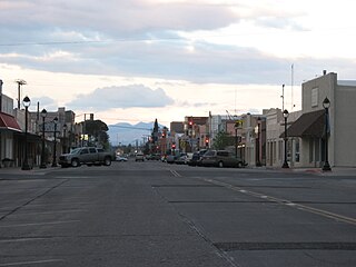
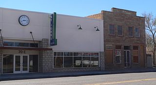
Safford is a city in Graham County, Arizona, United States. According to the 2020 Census, the population of the city is 10,129. The city is the county seat of Graham County.

<span class="mw-page-title-main">Swift Trail Junction, Arizona</span> CDP in Graham County, Arizona

Swift Trail Junction is a census-designated place (CDP) in Graham County, Arizona, United States. The population was 2,935 at the 2010 census, up from 2,195 in 2000. It is part of the Safford Micropolitan Statistical Area. It is situated at the junction of U.S. Route 191 and State Route 366. The Swift Trail Parkway is a scenic highway that winds through the Coronado National Forest and provides access to the higher elevations of the Pinaleño Mountains, also known as the Graham Mountains.

<span class="mw-page-title-main">Thatcher, Arizona</span> Town in Graham County, Arizona

Thatcher is a town in Graham County, Arizona, United States. According to the 2010 Census, the population of the town is 4,865. It is part of the Safford Micropolitan Statistical Area.

<span class="mw-page-title-main">Littlefield, Arizona</span> Census-designated place in Mohave County, Arizona, United States

Littlefield is an unincorporated community and census-designated place in Mohave County, Arizona, United States, that is located in the Arizona Strip region. As of the 2020 census, its population was 256, adecline from the figure of 308 tabulated in 2010. It lies just south of Interstate 15, next to the Virgin River, approximately 10 miles (16 km) northeast of Mesquite, Nevada. Littlefield is located in the 86432 ZIP Code.

<span class="mw-page-title-main">Mormon corridor</span> Areas of the western US settled by the LDS Church

The Mormon corridor is the areas of western North America that were settled between 1850 and approximately 1890 by members of the Church of Jesus Christ of Latter-day Saints, who are commonly called "Mormons".

<span class="mw-page-title-main">Beaver Dam, Arizona</span> Census-designated place in Arizona, United States

Beaver Dam is an unincorporated community and census-designated place (CDP) in Mohave County, Arizona, United States, that is located in the Arizona Strip region and was settled in 1863. It is located along Interstate 15 approximately 10 miles (16 km) northeast of Mesquite, Nevada. It is located in the 86432 ZIP Code. It had a population of 1,552 as of the 2020 census, down from 1,962 at the 2010 census.

<span class="mw-page-title-main">Gila River Valley</span> Valley in Arizona, United States of America

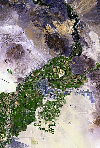
The Gila River Valley is a multi-sectioned valley of the Gila River, located primarily in Arizona. The Gila River forms in western New Mexico and flows west across southeastern, south-central, and southwestern Arizona; it changes directions as it progresses across the state, and defines specific areas and valleys. The central portion of the river flows through the southern Phoenix valley region, and the final sections in southwestern Arizona form smaller, irrigated valleys, such as Dome Valley, Mohawk Valley, and Hyder Valley.

<span class="mw-page-title-main">Central, Arizona</span> CDP in Graham County, Arizona

Central is a census-designated place in Graham County, Arizona, United States. Its population was 758 as of the 2020 census. It is part of the Safford micropolitan area.

<span class="mw-page-title-main">Gila Valley Arizona Temple</span> LDS Church temple in Graham County, Arizona

The Gila Valley Arizona Temple is a temple of the Church of Jesus Christ of Latter-day Saints in the town of Central between the communities of Pima and Thatcher in Arizona. The temple was dedicated on May 23, 2010, following an open house lasting from April 23 to May 15.

<span class="mw-page-title-main">Safford, Arizona micropolitan area</span> US Census Bureau statistical area (μSA)

The Safford Micropolitan Statistical Area, as defined by the United States Census Bureau, is a micropolitan statistical area (μSA) consisting of one county in eastern Arizona, anchored by the city of Safford.

<span class="mw-page-title-main">The Church of Jesus Christ of Latter-day Saints in Arizona</span> Aspect of church and state history

The Church of Jesus Christ of Latter-day Saints is the second-largest religious denomination in Arizona, behind the Roman Catholic Church. In 2022, the church reported 439,411 members in Arizona, about 6% of the state's population. According to the 2014 Pew Forum on Religion & Public Life survey, roughly 5% of Arizonans self-identify most closely with the Church of Jesus Christ of Latter-day Saints.

<span class="mw-page-title-main">The Church of Jesus Christ of Latter-day Saints in New Mexico</span>

The Church of Jesus Christ of Latter-day Saints in New Mexico refers to the Church of Jesus Christ of Latter-day Saints and its members in New Mexico. The first congregation of the Church in New Mexico was organized in 1895. It has since grown to 69,055 members in 137 congregations.

<span class="mw-page-title-main">Brigham City, Arizona</span> Ghost town in Navajo County

Brigham City is a ghost town in Navajo County, Arizona, United States. Founded by member of the Church of Jesus Christ of Latter-day Saints near the present city of Winslow in 1876, it was one and one-half miles north of Winslow's current city center, along the Little Colorado River. It was organized as a Latter-Day Saints ward in 1878, but by 1881 it had been abandoned.

Isaías Juárez (1885–1967) was a leader in the Church of Jesus Christ of Latter-day Saints in Mexico, an agriculturalist and a local judge and political leader in San Pedro Mártir.

Utah is the 30th most populous state in the United States with a population of about 3.3 million, according to projections from the US Census Bureau's 2017 estimates. The state has also been characterized by a tremendous amount of growth in the last decade, with the highest percent increase in population of any state since 2010. Utah has a surface area of 84,899 square miles, though around 80% of its population is concentrated around a metropolitan area in the north-central part of the state known as the Wasatch Front.

San Simon River is an ephemeral river, or stream running through the San Simon Valley in Graham and Cochise County, Arizona and Hidalgo County, New Mexico. Its mouth is at its confluence with the Gila River at Safford in Graham County. Its source is located at 31°51′21″N109°01′27″W.

References

  1. "2020 U.S. Gazetteer Files". United States Census Bureau. Retrieved October 29, 2021.
  2. "Solomon AZ ZIP Code". zipdatamaps.com. 2023. Retrieved May 3, 2023.
  3. 1 2 3 MABS – Solomon [ dead link ]
  4. 1 2 3 This is an official site of The Church of Jesus Christ of Latter-day Saints
  5. http://www.ahfweb.org/download/Ramenofsky_MSS_117.pdf [ bare URL PDF ]
  6. 1 2 Bloom Southwest Jewish Archives [ permanent dead link ]
  7. 1 2 Sarah Coleman (June 13, 1997). "Couple wed in Wild West town of pioneering ancestors". jweekly.com.
  8. Bloom Southwest Jewish Archives
  9. Graham County
  10. index
  11. Anna Solomon
  12. On the Upper Gila
  13. Columbia-Lippincott Gazetter, 1952, p. 1793
  14. "Census of Population and Housing". Census.gov. Retrieved June 4, 2016.
  15. 2010 demographic date for Solomon, Arizona from the US census
  16. Federal Assistance for Recipient Congressional District : Arizona 1 (Rick Renzi), Federal Fiscal Year : 2005, Recipient : Serrano, Antonio Serrano, Edwin in state NM, Level of Detail : Summary
  17. Outlaw Gang Lost Loot in Arizona
  18. Lowe, Sam (2012). "Bronco Bill Walters". Speaking Ill of the Dead: Jerks in New Mexico History. Guilford, Conn.: Globe Pequot Press. p. 52. ISBN   9780762783922.