
Maricopa County is in the south-central part of the U.S. state of Arizona. As of the 2020 census the population was 4,420,568, or about 62% of the state's total, making it the fourth-most populous county in the United States and the most populous county in Arizona, and making Arizona one of the nation's most centralized states. The county seat is Phoenix, the state capital and fifth-most populous city in the United States.
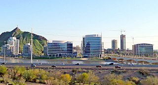
Tempe is a city in Maricopa County, Arizona, United States, with the Census Bureau reporting a 2020 population of 180,587. The city is named after the Vale of Tempe in Greece. Tempe is located in the East Valley section of metropolitan Phoenix; it is bordered by Phoenix and Guadalupe on the west, Scottsdale and the Salt River Pima–Maricopa Indian Community on the north, Chandler on the south, and Mesa on the east. Tempe is also the location of the main campus of Arizona State University.

The Gila River is a 649-mile-long (1,044 km) tributary of the Colorado River flowing through New Mexico and Arizona in the United States. The river drains an arid watershed of nearly 60,000 square miles (160,000 km2) that lies mainly within the U.S., but also extends into northern Sonora, Mexico.

The Salt River is a river in Gila and Maricopa counties in Arizona, United States, that is the largest tributary of the Gila River. The river is about 200 miles (320 km) long. Its drainage basin is about 13,700 square miles (35,000 km2) large. The longest of the Salt River's many tributaries is the 195-mile (314 km) Verde River. The Salt's headwaters tributaries, the Black River and East Fork, increase the river's total length to about 300 miles (480 km). The name Salt River comes from the fact that the river flows over large salt deposits shortly after the merging of the White and Black Rivers.
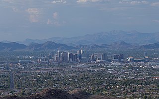
The Phoenix Metropolitan Area, also known as the Valley of the Sun, the Salt River Valley, Metro Phoenix, or The Valley, is the largest metropolitan statistical area in the Southwestern United States, centered on the city of Phoenix, that includes much of central Arizona. The United States Office of Management and Budget designates the area as the Phoenix-Mesa-Chandler Metropolitan Statistical Area (MSA), defining it as Maricopa and Pinal counties. It anchors the Arizona Sun Corridor megaregion along with the second-most populous metropolitan area in the state, the Tucson metropolitan area. The gross domestic product of the Phoenix Metropolitan Area was $255 billion in 2018, 16th-largest amongst metro areas in the United States.

The Arizona Canal is a major canal in central Maricopa County that led to the founding of several communities, now among the wealthier neighborhoods of suburban Phoenix, constructed in the late 1880s. Flood irrigation of residential yards is still common in these neighborhoods, using a system of lateral waterways connected via gates to the canal itself. Like most Valley canals, its banks are popular with joggers and bicyclists.

Tortilla Flat is a small unincorporated community in far eastern Maricopa County, Arizona, United States. It is located in the central part of the state, northeast of Apache Junction. It is the last surviving stagecoach stop along the Apache Trail. According to the Gross Management Department of Arizona's main U.S. Post Office in Phoenix, Tortilla Flat is presumed to be Arizona's smallest official "community" having a U.S. Post Office and voting precinct. The town has a population of 6. Tortilla Flat can be reached by vehicles on the Apache Trail, via Apache Junction.
The Salt River Project (SRP) encompasses two separate entities: the Salt River Project Agricultural Improvement and Power District, an agency of the state of Arizona that serves as an electrical utility for the Phoenix metropolitan area, and the Salt River Valley Water Users' Association, a utility cooperative that serves as the primary water provider for much of central Arizona. It is one of the primary public utility companies in Arizona.
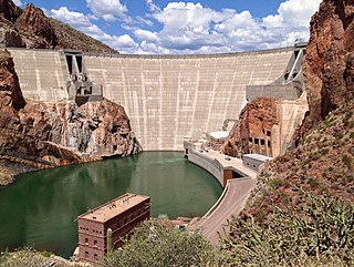
Theodore Roosevelt Dam is a dam on the Salt River located northeast of Phoenix, Arizona. The dam is 357 feet (109 m) high and forms Theodore Roosevelt Lake as it impounds the Salt River. Originally built between 1905 and 1911, the dam was renovated and expanded in 1989–1996. The dam is named after President Theodore Roosevelt. Serving mainly for irrigation, water supply, and flood control, the dam also has a hydroelectric generating capacity of 36 megawatts.

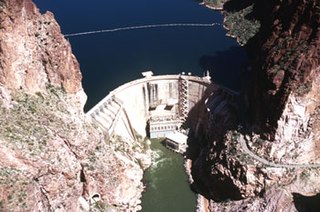
The Stewart Mountain Dam is a concrete thin arch dam located 41 miles northeast of Phoenix, Arizona. The dam is 1,260 feet (380 m) long, 207 feet (63 m) high, and was built between 1928 and 1930. The dam includes a 13,000 kilowatt (kW) hydroelectric generating unit that is operated by SRP, an Arizona public utility. It is primarily operated during the summer months. The dam forms Saguaro Lake as it slows the passage of the Salt River in Maricopa County, Arizona. It was named after a ranch that used to be located nearby known as the Old Stewart Ranch.

This is a list of the National Register of Historic Places listings in Maricopa County, Arizona, excluding those in Phoenix, for which see this separate list.

The Mill Avenue Bridges consist of two bridges that cross the Salt River in Tempe, Arizona, at the north end of the shopping district on Mill Avenue. The first bridge opened in August 1931 and the second bridge opened in 1994.

The Granite Reef Diversion Dam is a concrete diversion dam located 22 miles (35 km) Northeast of Phoenix, Arizona. It impounds the Salt River for irrigation purposes.
The Horse Mesa Dam is a concrete thin arch dam located in the Superstition Mountains, northeast of Phoenix in Maricopa County, Arizona.

The Bartlett Dam is a concrete multiple-arch buttress dam on the Verde River, located 50 km northeast of Phoenix, Arizona. The dam creates Bartlett Lake and its primary purpose is irrigation water supply. It was the first dam constructed on the Verde River and the first of its type constructed by the U.S. Bureau of Reclamation. It was built between 1936 and 1939. It was named after Bill Bartlett, a government surveyor. It was listed on the National Register of Historic Places in 2017.

Arizona is a landlocked state situated in the southwestern region of the United States of America. It has a vast and diverse geography famous for its deep canyons, high- and low-elevation deserts, numerous natural rock formations, and volcanic mountain ranges. Arizona shares land borders with Utah to the north, the Mexican state of Sonora to the south, New Mexico to the east, and Nevada to the northwest, as well as water borders with California and the Mexican state of Baja California to the southwest along the Colorado River. Arizona is also one of the Four Corners states and is diagonally adjacent to Colorado.

Salt River is a populated place situated in Maricopa County, Arizona, United States. It has an estimated elevation of 1,220 feet (370 m) above sea level. It is located on the Salt River Pima–Maricopa Indian Community.

The Gillespie Dam Bridge is a through truss bridge spanning the Gila River in Maricopa County, in the U.S. state of Arizona. The bridge was constructed to bypass a concrete apron through the river in front of the Gillespie Dam, which was often closed due to flooding. Construction of the bridge started in 1925 and completed in 1927. From its opening until 1956, the bridge was part of U.S. Route 80 (US 80), a transcontinental highway between San Diego, California and Tybee Island, Georgia. The bridge was restored in 2012 by Maricopa County for the Arizona Centennial and now includes an educational interpretive center for visitors. The bridge became part of Historic US 80 in 2018.
