National Register of Historic Places listings in Graham County, Arizona

Last updated

Location of Graham County in Arizona Map of Arizona highlighting Graham County.svg
Location of Graham County in Arizona

This is a list of the National Register of Historic Places listings in Graham County, Arizona. It is intended to be a complete list of the properties and districts on the National Register of Historic Places in Graham County, Arizona, United States. The locations of National Register properties and districts for which the latitude and longitude coordinates are included below, may be seen in a map. [1]

Contents

There are 34 properties and districts listed on the National Register in the county, including 2 that are also National Historic Landmarks.


    This National Park Service list is complete through NPS recent listings posted September 22, 2023. [2]

Map all coordinates using: OpenStreetMap

Current listings

[3] Name on the RegisterImageDate listed [4] Location City or townDescription
1 Arizona Bank and Trust
Arizona Bank and Trust AZ Bank and Trust3.jpg
Arizona Bank and Trust
February 9, 1988
(#87002557)
429 Main
32°49′59″N109°42′42″W / 32.833056°N 109.711667°W / 32.833056; -109.711667 (Arizona Bank and Trust)
Safford
2 Richard Bingham House
Richard Bingham House Bingham house (Safford AZ) from NE 2.JPG
Richard Bingham House
February 9, 1988
(#87002556)
1208 9th Ave.
32°49′34″N109°43′05″W / 32.826222°N 109.718114°W / 32.826222; -109.718114 (Richard Bingham House)
Safford
3 Bonita Store
Bonita Store Bonita Store.JPG
Bonita Store
March 6, 1998
(#98000172)
1 mile northwest of the junction of State Route 266 and Arizona Industrial School Rd.
32°35′22″N109°58′08″W / 32.589444°N 109.968889°W / 32.589444; -109.968889 (Bonita Store)
Bonita
4 Paul Brooks House
Paul Brooks House Paul Brooks house (Safford AZ) from SW 1.JPG
Paul Brooks House
February 9, 1988
(#87002559)
1033 5th Ave.
32°49′40″N109°42′44″W / 32.827885°N 109.712295°W / 32.827885; -109.712295 (Paul Brooks House)
Safford
5 Buena Vista Hotel
Buena Vista Hotel Safford, AZ 300s block Main from SE.JPG
Buena Vista Hotel
February 9, 1988
(#87002560)
322 Main
32°50′00″N109°42′38″W / 32.833333°N 109.710556°W / 32.833333; -109.710556 (Buena Vista Hotel)
Safford No longer extant [5]
6 Columbine Work Station
Columbine Work Station Columbine Work Station residence.jpg
Columbine Work Station
June 10, 1993
(#93000516)
State Route 366 southwest of Safford in the Coronado National Forest
32°42′13″N109°54′46″W / 32.703611°N 109.912778°W / 32.703611; -109.912778 (Columbine Work Station)
Safford
7 T. D. Cross House
T. D. Cross House T. D. Cross house (Safford AZ) from NE 1.JPG
T. D. Cross House
February 9, 1988
(#87002563)
908 1st Ave. [6]
32°49′47″N109°42′28″W / 32.829657°N 109.707904°W / 32.829657; -109.707904 (T. D. Cross House)
Safford
8 William Charles Davis House
William Charles Davis House William Charles Davis house (Safford AZ) from NE 2.JPG
William Charles Davis House
February 9, 1988
(#87002565)
301 11th St.
32°49′38″N109°42′37″W / 32.827337°N 109.710283°W / 32.827337; -109.710283 (William Charles Davis House)
Safford
9 Graham County Courthouse
Graham County Courthouse GrahamCountyCourthouse.jpg
Graham County Courthouse
May 25, 1982
(#82002077)
800 Main St.
32°49′59″N109°42′57″W / 32.833056°N 109.715833°W / 32.833056; -109.715833 (Graham County Courthouse)
Safford
10 Heliograph Lookout Complex
Heliograph Lookout Complex Heliograph complex fire lookout, communication towers and historic cabin.jpg
Heliograph Lookout Complex
January 28, 1988
(#87002467)
Coronado National Forest
32°39′00″N109°50′56″W / 32.65°N 109.848889°W / 32.65; -109.848889 (Heliograph Lookout Complex)
Old Columbine
11 Joe Horowitz House
Joe Horowitz House Joe Horowitz house (Safford AZ) from S 1.JPG
Joe Horowitz House
February 9, 1988
(#87002566)
118 Main
32°50′01″N109°42′31″W / 32.833512°N 109.708573°W / 32.833512; -109.708573 (Joe Horowitz House)
Safford
12 House at 611 Third Avenue
House at 611 Third Avenue Safford Arizona 611 3rd Ave from SW 2.JPG
House at 611 Third Avenue
February 9, 1988
(#87002568)
611 3rd Ave.
32°49′58″N109°42′35″W / 32.832846°N 109.709736°W / 32.832846; -109.709736 (House at 611 Third Avenue)
Safford
13 Kearny Campsite and Trail
Kearny Campsite and Trail Gila Box, Gila River x Bonita Creek 1.JPG
Kearny Campsite and Trail
October 9, 1974
(#74000454)
Northeast of Safford off U.S. Route 666
32°53′38″N109°28′44″W / 32.893841°N 109.478996°W / 32.893841; -109.478996 (Kearny Campsite and Trail)
Safford
14 Marijilda Canyon Prehistoric Archeological District October 2, 1988
(#88001572)
Address Restricted
Safford
15 Mathew O'Brien House
Mathew O'Brien House Matthew O'Brien house (Safford AZ) from W 1.JPG
Mathew O'Brien House
February 9, 1988
(#87002570)
615 1st Ave.
32°49′57″N109°42′26″W / 32.832505°N 109.707341°W / 32.832505; -109.707341 (Mathew O'Brien House)
Safford
16 Oak Draw Archeological District November 25, 1992
(#92001564)
Address Restricted
Safford
17 Oddfellows Home
Oddfellows Home Safford, Arizona IOOF home from E 1.JPG
Oddfellows Home
May 12, 1988
(#87002571)
808 8th Ave.
32°49′49″N109°43′01″W / 32.83040°N 109.71681°W / 32.83040; -109.71681 (Oddfellows Home)
Safford
18 George A. Olney House
George A. Olney House Safford, Arizona Olney house from E 1.JPG
George A. Olney House
February 9, 1988
(#87002574)
1104 Central
32°49′39″N109°42′42″W / 32.827368°N 109.711544°W / 32.827368; -109.711544 (George A. Olney House)
Safford
19 Alonzo Hamilton Packer House
Alonzo Hamilton Packer House Packer house (Safford AZ) from NW 2.JPG
Alonzo Hamilton Packer House
February 9, 1988
(#87002575)
1203 Central
32°49′34″N109°42′39″W / 32.826077°N 109.710956°W / 32.826077; -109.710956 (Alonzo Hamilton Packer House)
Safford
20 Point of Pines
Point of Pines Point of Pines Sites.jpg
Point of Pines
October 15, 1966
(#66000182)
Address Restricted
Morenci
21 Power's Cabin
Power's Cabin Power Cabin.jpg
Power's Cabin
August 13, 1975
(#75000348)
Northwest of Willcox in the Coronado National Forest
32°35′38″N110°20′43″W / 32.593889°N 110.345278°W / 32.593889; -110.345278 (Power's Cabin)
Willcox Location of the 1918 Power's Cabin Shootout
22 David Ridgeway House
David Ridgeway House David Ridgeway house (Safford AZ) from NE 1.JPG
David Ridgeway House
February 9, 1988
(#87002576)
928 Central
32°49′46″N109°42′42″W / 32.829474°N 109.711528°W / 32.829474; -109.711528 (David Ridgeway House)
Safford
23 Safford High School
Safford High School Old Safford High School.jpg
Safford High School
February 9, 1988
(#87002577)
520 11th St.
32°49′41″N109°42′47″W / 32.828056°N 109.713056°W / 32.828056; -109.713056 (Safford High School)
Safford School building built in 1915, listed on the National Register in 1988, and apparently razed in mid-1990s but still not yet delisted.
24 Sierra Bonita Ranch
Sierra Bonita Ranch Sierra Bonita Ranch.jpg
Sierra Bonita Ranch
October 15, 1966
(#66000181)
Southwest of Bonita
32°30′36″N110°02′15″W / 32.51°N 110.0375°W / 32.51; -110.0375 (Sierra Bonita Ranch)
Bonita Extends into Cochise County
25 Southern Pacific Railroad Depot
Southern Pacific Railroad Depot Safford, Arizona Southern Pacific depot from SE 1.JPG
Southern Pacific Railroad Depot
February 9, 1988
(#87002578)
808 Central
32°49′52″N109°42′42″W / 32.831099°N 109.711579°W / 32.831099; -109.711579 (Southern Pacific Railroad Depot)
Safford
26 Hugh Talley House
Hugh Talley House Hugh Talley house (Safford AZ) from E 1.JPG
Hugh Talley House
February 9, 1988
(#87002580)
1114 3rd Ave.
32°49′37″N109°42′37″W / 32.826862°N 109.710299°W / 32.826862; -109.710299 (Hugh Talley House)
Safford
27 William Talley House
William Talley House William Talley house (Safford AZ) from NE 1.JPG
William Talley House
February 9, 1988
(#87002581)
219 11th St.
32°49′38″N109°42′35″W / 32.827337°N 109.709788°W / 32.827337; -109.709788 (William Talley House)
Safford
28 Webb Peak Lookout Tower January 28, 1988
(#87002464)
Off State Route 366
32°42′41″N109°55′19″W / 32.711389°N 109.921944°W / 32.711389; -109.921944 (Webb Peak Lookout Tower)
Old Columbine
29 James R. Welker House
James R. Welker House Welker house (Safford AZ) from SW 1.JPG
James R. Welker House
February 9, 1988
(#87002582)
1127 Central
32°49′36″N109°42′40″W / 32.82657°N 109.71098°W / 32.82657; -109.71098 (James R. Welker House)
Safford House built in 1915 with elements of Queen Anne style
30 West Peak Lookout Tower January 28, 1988
(#87002466)
Coronado National Forest
32°44′15″N110°02′15″W / 32.7375°N 110.0375°W / 32.7375; -110.0375 (West Peak Lookout Tower)
Bonita
31 David Wickersham House
David Wickersham House David Wickersham house (Safford AZ) from NW 2.JPG
David Wickersham House
February 9, 1988
(#87002583)
1101 5th Ave.
32°49′38″N109°42′43″W / 32.827258°N 109.712064°W / 32.827258; -109.712064 (David Wickersham House)
Safford
32 Dan Williams House
Dan Williams House Dan Williams house (Safford AZ) from N 1.JPG
Dan Williams House
February 9, 1988
(#87002584)
603 Relation
32°49′26″N109°42′51″W / 32.823764°N 109.714059°W / 32.823764; -109.714059 (Dan Williams House)
Safford
33 J. Mark Wilson House
J. Mark Wilson House J. Mark Wilson house (Safford AZ) from SW 1.JPG
J. Mark Wilson House
February 9, 1988
(#87002585)
712 Relation
32°49′28″N109°42′57″W / 32.824323°N 109.715893°W / 32.824323; -109.715893 (J. Mark Wilson House)
Safford
34 Woman's Club
Woman's Club Womens Club2.jpg
Woman's Club
May 12, 1988
(#87002586)
215 Main
32°49′59″N109°42′35″W / 32.83306°N 109.70979°W / 32.83306; -109.70979 (Woman's Club)
Safford Woman's Club building designed by M.H. Starkweather and built in 1930.

See also

Related Research Articles

<span class="mw-page-title-main">National Register of Historic Places listings in Onondaga County, New York</span>

This is a list of the properties and districts listed on the National Register of Historic Places listings in Onondaga County, New York. The locations of National Register properties and districts may be seen in a map by clicking on "Map of all coordinates". There are 170 properties and districts listed on the National Register in the county. Of those, 55 are outside Syracuse, and are listed here, while the rest are covered in National Register of Historic Places listings in Syracuse, New York. One property, the New York State Barge Canal, spans the city and the remainder of the county.

<span class="mw-page-title-main">National Register of Historic Places listings in Coconino County, Arizona</span>

This is a list of the National Register of Historic Places listings in Coconino County, Arizona.

<span class="mw-page-title-main">National Register of Historic Places listings in Pima County, Arizona</span>

This is a list of the National Register of Historic Places listings in Pima County, Arizona.

<span class="mw-page-title-main">National Register of Historic Places listings in Accomack County, Virginia</span>

This is a list of the National Register of Historic Places listings in Accomack County, Virginia.

<span class="mw-page-title-main">National Register of Historic Places listings in Pinal County, Arizona</span>

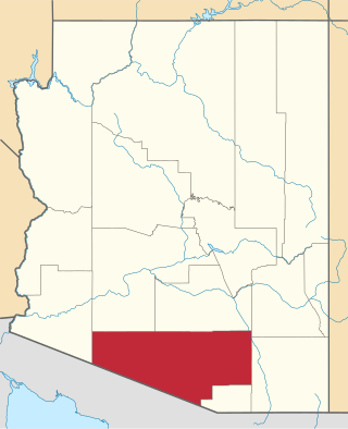
This is a list of the National Register of Historic Places listings in Pinal County, Arizona.

<span class="mw-page-title-main">National Register of Historic Places listings in Greenlee County, Arizona</span>

This is a list of the National Register of Historic Places listings in Greenlee County, Arizona.

<span class="mw-page-title-main">National Register of Historic Places listings in Apache County, Arizona</span>

This is a list of the National Register of Historic Places listings in Apache County, Arizona. It is intended to be a complete list of the properties and districts on the National Register of Historic Places in Apache County, Arizona, United States. The locations of National Register properties and districts for which the latitude and longitude coordinates are included below, may be seen in a map.

<span class="mw-page-title-main">National Register of Historic Places listings in Santa Cruz County, Arizona</span>

This is intended to be a complete list of the properties and districts on the National Register of Historic Places in Santa Cruz County, Arizona, United States. The locations of National Register properties and districts for which the latitude and longitude coordinates are included below, may be seen in a map.

<span class="mw-page-title-main">National Register of Historic Places listings in Cochise County, Arizona</span>

This is a list of the National Register of Historic Places listings in Cochise County, Arizona. It is intended to be a complete list of the properties and districts on the National Register of Historic Places in Cochise County, Arizona, United States. The locations of National Register properties and districts for which the latitude and longitude coordinates are included below, may be seen in a map.

<span class="mw-page-title-main">National Register of Historic Places listings in Gila County, Arizona</span>

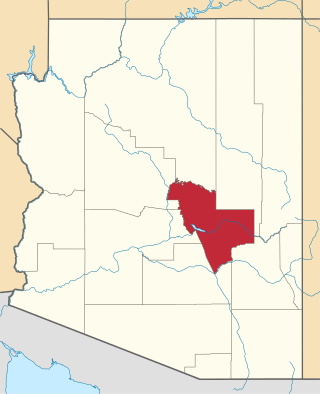
This is a list of the National Register of Historic Places listings in Gila County, Arizona.

<span class="mw-page-title-main">National Register of Historic Places listings in Bon Homme County, South Dakota</span>

This is a list of the National Register of Historic Places listings in Bon Homme County, South Dakota.

<span class="mw-page-title-main">National Register of Historic Places listings in Brookings County, South Dakota</span>

This is a list of the National Register of Historic Places listings in Brookings County, South Dakota.

<span class="mw-page-title-main">National Register of Historic Places listings in Yankton County, South Dakota</span>

This is a list of the National Register of Historic Places listings in Yankton County, South Dakota.

<span class="mw-page-title-main">National Register of Historic Places listings in Union County, South Dakota</span>

This is a list of the National Register of Historic Places listings in Union County, South Dakota.

<span class="mw-page-title-main">National Register of Historic Places listings in Lincoln County, South Dakota</span>

This is a list of the National Register of Historic Places listings in Lincoln County, South Dakota.

<span class="mw-page-title-main">National Register of Historic Places listings in Turner County, South Dakota</span>

This is a list of the National Register of Historic Places listings in Turner County, South Dakota.

<span class="mw-page-title-main">National Register of Historic Places listings in Vinton County, Ohio</span>

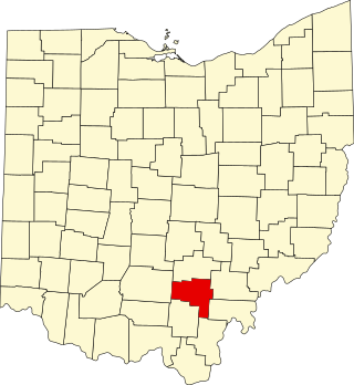
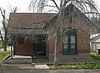
This is a list of the National Register of Historic Places listings in Vinton County, Ohio.

<span class="mw-page-title-main">National Register of Historic Places listings in Prescott, Arizona</span>

This is a list of the National Register of Historic Places listings in Prescott, Arizona. It is intended to be a complete list of the properties and districts on the National Register of Historic Places in Prescott, Arizona, United States. The locations of National Register properties and districts for which the latitude and longitude coordinates are included below, may be seen in an online map.

<span class="mw-page-title-main">National Register of Historic Places listings in Cooper County, Missouri</span>

This is a list of the National Register of Historic Places listings in Cooper County, Missouri.

<span class="mw-page-title-main">National Register of Historic Places listings in Roosevelt County, New Mexico</span>

This is a list of the National Register of Historic Places listings in Roosevelt County, New Mexico.

References

  1. The latitude and longitude information provided in this table was derived originally from the National Register Information System, which has been found to be fairly accurate for about 99% of listings. Some locations in this table may have been corrected to current GPS standards.
  2. National Park Service, United States Department of the Interior, "National Register of Historic Places: Weekly List Actions", retrieved September 22, 2023.
  3. Numbers represent an alphabetical ordering by significant words. Various colorings, defined here, differentiate National Historic Landmarks and historic districts from other NRHP buildings, structures, sites or objects.
  4. The eight-digit number below each date is the number assigned to each location in the National Register Information System database, which can be viewed by clicking the number.
  5. See "Buena Vista showcased musical talents", Eastern Arizona Courier, 2005-10-19, retrieved 2015-03-16; and Robinson, Stephany Mae, "Mt. Graham timber built Valley", Eastern Arizona Courier, 2011-10-19, retrieved 2015-03-16. See also 2015 photo of 300s block of Main.
  6. On the NRHP nominating form, the address is given as "918 1st Ave." However, a 2015 photo shows the address "908" marked on the house.