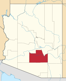
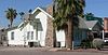
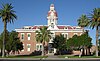
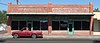
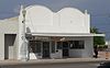
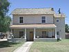
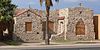
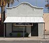
[3] Name on the Register Image Date listed [4] Location City or town Description 1 Acadia Ranch Acadia Ranch February 22, 1984 (# 84000765 825 E. Mt. Lemmon Highway [5] 32°36′34″N 110°45′54″W / 32.609556°N 110.764955°W / 32.609556; -110.764955 (Acadia Ranch ) Oracle Now the Acadia Ranch Museum [5] 2 Adamsville Ruin Adamsville Ruin August 25, 1970 (# 70000114 Address Restricted Florence Water tanks which once served Adamsville. 3 All Saints' Church All Saints' Church May 3, 1984 (# 84000768 705 E. American Avenue [6] 32°36′35″N 110°45′59″W / 32.609786°N 110.766516°W / 32.609786; -110.766516 (All Saints' Church ) Oracle 4 American Flag Post Office Ranch American Flag Post Office Ranch June 20, 1979 (# 79000426 5 miles southeast of Oracle 32°34′48″N 110°43′14″W / 32.580066°N 110.72054°W / 32.580066; -110.72054 (American Flag Post Office Ranch ) Oracle Oldest surviving territorial post office building in Arizona. 5 Ramon Arballo House Ramon Arballo House August 1, 1986 (# 86002623 515 Park St. [7] 33°02′12″N 111°22′59″W / 33.036593°N 111.38308°W / 33.036593; -111.38308 (Ramon Arballo House ) Florence 6 Encarnacion Avenenti House Encarnacion Avenenti House July 13, 1987 (# 87001592 203 Butte St. 33°01′52″N 111°23′07″W / 33.031111°N 111.385278°W / 33.031111; -111.385278 (Encarnacion Avenenti House ) Florence Demolished 7 Earl Bayless House Earl Bayless House April 16, 1985 (# 85000878 211 N. Cameron 32°52′31″N 111°44′52″W / 32.875392°N 111.747851°W / 32.875392; -111.747851 (Earl Bayless House ) Casa Grande 8 Wilbur O. Bayless/Grasty House Wilbur O. Bayless/Grasty House April 16, 1985 (# 85000879 221 N. Cameron 32°52′32″N 111°44′52″W / 32.875582°N 111.74785°W / 32.875582; -111.74785 (Wilbur O. Bayless/Grasty House ) Casa Grande Listed erroneously in NRHP as "Wilbur O. Baylis/Grasty House". [8] 9 Bien/McNatt House Bien/McNatt House April 16, 1985 (# 85000880 208A W. 1st St. 32°52′38″N 111°45′19″W / 32.877348°N 111.755404°W / 32.877348; -111.755404 (Bien/McNatt House ) Casa Grande 10 Dr. George M. and Esther A. Brockway House Dr. George M. and Esther A. Brockway House May 26, 2004 (# 04000485 501 S. Central Ave. 33°01′43″N 111°23′25″W / 33.028611°N 111.390278°W / 33.028611; -111.390278 (Dr. George M. and Esther A. Brockway House ) Florence 11 Building at 121 North Florence Street Building at 121 North Florence Street November 20, 2002 (# 02000737 121 N. Florence St. 32°52′35″N 111°45′16″W / 32.876346°N 111.754496°W / 32.876346; -111.754496 (Building at 121 North Florence Street ) Casa Grande 12 Building at 400 East Third Street Building at 400 East Third Street November 20, 2002 (# 02000749 400 E. 3rd St. 32°52′36″N 111°45′00″W / 32.876566°N 111.750041°W / 32.876566; -111.750041 (Building at 400 East Third Street ) Casa Grande 13 Butte-Cochran Charcoal Ovens Upload image May 30, 1975 (# 75000358 16 miles east of Florence north of Gila River 33°06′16″N 111°09′52″W / 33.104444°N 111.164444°W / 33.104444; -111.164444 (Butte-Cochran Charcoal Ovens ) Florence 14 Chi'chil Bildagoteel Historic District Chi'chil Bildagoteel Historic District March 4, 2016 (# 16000002 Including and surrounding the Oak Flat campground [9] 33°18′29″N 111°03′00″W / 33.308056°N 111.050000°W / 33.308056; -111.050000 (Chi'chil Bildagoteel Historic District ) Superior 15 Camp Grant Massacre Site Upload image March 6, 1998 (# 98000171 Address Restricted Mammoth 16 Carminatti-Perham House Carminatti-Perham House August 1, 1986 (# 86002624 6th and Florence Sts. 33°02′08″N 111°23′01″W / 33.035594°N 111.383628°W / 33.035594; -111.383628 (Carminatti-Perham House ) Florence 17 Casa Grande Dispatch Casa Grande Dispatch November 20, 2002 (# 02000747 109 E. 2nd St. 32°52′37″N 111°45′12″W / 32.876837°N 111.753387°W / 32.876837; -111.753387 (Casa Grande Dispatch ) Casa Grande 18 Casa Grande Hospital Casa Grande Hospital November 20, 2002 (# 02000740 601 N. Cameron Ave. 32°52′44″N 111°44′52″W / 32.878817°N 111.747845°W / 32.878817; -111.747845 (Casa Grande Hospital ) Casa Grande 19 Casa Grande Hotel Casa Grande Hotel April 16, 1985 (# 85000881 201 W. Main Ave. 32°52′33″N 111°45′23″W / 32.875754°N 111.756275°W / 32.875754; -111.756275 (Casa Grande Hotel ) Casa Grande 20 Casa Grande National Monument Casa Grande National Monument October 15, 1966 (# 66000192 Casa Grande National Monument 32°59′49″N 111°31′55″W / 32.996944°N 111.531944°W / 32.996944; -111.531944 (Casa Grande National Monument ) Coolidge 21 Casa Grande Stone Church Casa Grande Stone Church June 15, 1978 (# 78000567 110 W. Florence Boulevard [10] 32°52′47″N 111°45′15″W / 32.879788°N 111.754285°W / 32.879788; -111.754285 (Casa Grande Stone Church ) Casa Grande Now the Casa Grande Valley Historical Society museum [10] 22 Casa Grande Union High School and Gymnasium Casa Grande Union High School and Gymnasium February 3, 1986 (# 86000821 510 E. Florence Boulevard [10] 32°52′49″N 111°44′51″W / 32.880276°N 111.747625°W / 32.880276; -111.747625 (Casa Grande Union High School and Gymnasium ) Casa Grande Now Casa Grande's city hall. [10] 23 Casa Grande Woman's Club Building Casa Grande Woman's Club Building March 21, 1979 (# 79000425 407 N. Sacaton St. 32°52′46″N 111°45′18″W / 32.87933°N 111.754888°W / 32.87933; -111.754888 (Casa Grande Woman's Club Building ) Casa Grande 24 Central Creditors Association Building Central Creditors Association Building April 16, 1985 (# 85000882 118 N. Sacaton 32°52′38″N 111°45′21″W / 32.877215°N 111.755886°W / 32.877215; -111.755886 (Central Creditors Association Building ) Casa Grande 25 Church of the Nazarene Church of the Nazarene November 20, 2002 (# 02000750 305 E. 4th St. 32°52′39″N 111°45′03″W / 32.877461°N 111.750707°W / 32.877461; -111.750707 (Church of the Nazarene ) Casa Grande 26 Albert Colton and H. H. Freeman House Albert Colton and H. H. Freeman House August 1, 1986 (# 86002625 Willow Street and Butte Avenue, southwest corner 33°01′52″N 111°23′23″W / 33.031063°N 111.389689°W / 33.031063; -111.389689 (Albert Colton and H. H. Freeman House ) Florence 27 Coolidge Dam Coolidge Dam October 29, 1981 (# 81000135 Southwest of San Carlos 33°10′26″N 110°31′37″W / 33.173889°N 110.526944°W / 33.173889; -110.526944 (Coolidge Dam ) San Carlos (ed. note: does this span 2 counties, should appear in other county list too) 28 Coolidge Woman's Club Coolidge Woman's Club October 4, 1990 (# 90001524 240 W. Pinkley Ave. 32°58′44″N 111°31′07″W / 32.979011°N 111.51874°W / 32.979011; -111.51874 (Coolidge Woman's Club ) Coolidge 29 William Cox Building William Cox Building September 3, 1999 (# 99001068 501 N. Marshall St. 32°52′43″N 111°45′06″W / 32.878495°N 111.751672°W / 32.878495; -111.751672 (William Cox Building ) Casa Grande 30 Cruz Trading Post Cruz Trading Post April 16, 1985 (# 85000883 200 W. Main St. 32°52′35″N 111°45′20″W / 32.87643°N 111.75564°W / 32.87643; -111.75564 (Cruz Trading Post ) Casa Grande Commercial building built around 1888, renovated in Pueblo Revival style around 1937. 31 Judge William T. Day House Judge William T. Day House July 25, 1985 (# 85001624 306 W. 1st St. [10] 32°52′40″N 111°45′22″W / 32.877862°N 111.756208°W / 32.877862; -111.756208 (Judge William T. Day House ) Casa Grande 32 Devil's Canyon Bridge Devil's Canyon Bridge September 30, 1988 (# 88001681 Abandoned U.S. Route 60 over Devil's Canyon 33°19′40″N 111°01′56″W / 33.32791°N 111.03209°W / 33.32791; -111.03209 (Devil's Canyon Bridge ) Superior Filled spandrel arch bridge 33 James S. Melquides E. Douglass House James S. Melquides E. Douglass House May 27, 2004 (# 04000486 850 S. Park St. 33°01′27″N 111°23′00″W / 33.024063°N 111.383453°W / 33.024063; -111.383453 (James S. Melquides E. Douglass House ) Florence 34 Evergreen Addition Historic District Evergreen Addition Historic District January 22, 2009 (# 08001346 Generally bounded by McMurray Blvd., Gilbert Ave., Florence Blvd., and Casa Grande Ave. 32°52′59″N 111°44′43″W / 32.883125°N 111.745369°W / 32.883125; -111.745369 (Evergreen Addition Historic District ) Casa Grande 35 First Baptist Church First Baptist Church November 20, 2002 (# 02000751 218 E. 8th St. 32°52′51″N 111°45′04″W / 32.88088°N 111.751213°W / 32.88088; -111.751213 (First Baptist Church ) Casa Grande 36 First Florence Courthouse First Florence Courthouse July 30, 1974 (# 74000461 5th and Main Sts. 33°02′32″N 111°23′40″W / 33.042222°N 111.394444°W / 33.042222; -111.394444 (First Florence Courthouse ) Florence 1878 courthouse, now preserved within McFarland State Historic Park . 37 First Presbyterian Church of Florence First Presbyterian Church of Florence June 10, 1994 (# 94000573 225 E. Butte Ave. 33°01′52″N 111°23′06″W / 33.030998°N 111.385049°W / 33.030998; -111.385049 (First Presbyterian Church of Florence ) Florence 38 Florence Townsite Historic District Florence Townsite Historic District October 26, 1982 (# 82001623 Roughly bounded by 3rd and Florence Sts., Butte and Central Aves., and Chase/Ruggles Ditch 33°02′01″N 111°23′13″W / 33.033611°N 111.386944°W / 33.033611; -111.386944 (Florence Townsite Historic District ) Florence Main Street 39 Florence Union High School Florence Union High School June 22, 1987 (# 87001306 1000 S. Main St. 33°01′21″N 111°23′16″W / 33.0225°N 111.387778°W / 33.0225; -111.387778 (Florence Union High School ) Florence 40 Thomas Fulbright House Thomas Fulbright House October 4, 1996 (# 96001055 75 S. Matilda St. 33°01′50″N 111°23′02″W / 33.030647°N 111.383933°W / 33.030647; -111.383933 (Thomas Fulbright House ) Florence 41 Grewe Site Upload image May 30, 2001 (# 01000565 Address Restricted Coolidge 42 Ha-ak Va-ak Intaglio Site Upload image September 6, 1979 (# 79000427 Address Restricted Sacaton 43 Harvey-Niemeyer House Harvey-Niemeyer House August 1, 1986 (# 86002627 250 S. Main St. 33°01′45″N 111°23′13″W / 33.029167°N 111.386944°W / 33.029167; -111.386944 (Harvey-Niemeyer House ) Florence Address was 1613 Main St. 44 C. D. Henry House C. D. Henry House August 1, 1986 (# 86002628 144 S. Willow St. 33°01′49″N 111°23′20″W / 33.030278°N 111.388889°W / 33.030278; -111.388889 (C. D. Henry House ) Florence Address was 1520 Willow St. 45 Hieroglyphic Canyon Site Hieroglyphic Canyon Site April 11, 1994 (# 94000269 Address Restricted Apache Junction 46 Hohokam-Pima National Monument Hohokam-Pima National Monument July 19, 1974 (# 74002221 20 miles (30 km) south of Phoenix on Interstate 10 33°11′12″N 111°55′00″W / 33.186667°N 111.916667°W / 33.186667; -111.916667 (Hohokam-Pima National Monument ) Gila River Indian Reservation 47 House at 222 West Ninth St. House at 222 West Ninth St. November 20, 2002 (# 02000743 222 W. 9th St. 32°52′55″N 111°45′21″W / 32.881895°N 111.755823°W / 32.881895; -111.755823 (House at 222 West Ninth St. ) Casa Grande 48 House at 317 East Eighth Street House at 317 East Eighth Street November 20, 2002 (# 02000753 317 E. 8th St. 32°52′49″N 111°45′00″W / 32.880342°N 111.749926°W / 32.880342; -111.749926 (House at 317 East Eighth Street ) Casa Grande 49 House at 320 West Eighth Street House at 320 West Eighth Street November 20, 2002 (# 02000745 320 W. 8th St. 32°52′51″N 111°45′26″W / 32.880778°N 111.757101°W / 32.880778; -111.757101 (House at 320 West Eighth Street ) Casa Grande 50 House at 323 West Eighth St. House at 323 West Eighth St. November 20, 2002 (# 02000744 323 W. 8th St. 32°52′49″N 111°45′26″W / 32.880317°N 111.757101°W / 32.880317; -111.757101 (House at 323 West Eighth St. ) Casa Grande 51 House at 59 North Brown Avenue House at 59 North Brown Avenue November 20, 2002 (# 02000742 59 N. Brown Ave. 32°52′21″N 111°44′44″W / 32.872547°N 111.745575°W / 32.872547; -111.745575 (House at 59 North Brown Avenue ) Casa Grande 52 House at 736 North Center Avenue House at 736 North Center Avenue November 20, 2002 (# 02000738 736 N. Center Ave. 32°52′49″N 111°45′11″W / 32.880274°N 111.753159°W / 32.880274; -111.753159 (House at 736 North Center Avenue ) Casa Grande 53 House at North Lehmberg Avenue House at North Lehmberg Avenue November 20, 2002 (# 02000735 1105 N. Lehmberg Ave. 32°53′08″N 111°44′37″W / 32.885531°N 111.743516°W / 32.885531; -111.743516 (House at North Lehmberg Avenue ) Casa Grande 54 Dr. George Huffman House Dr. George Huffman House August 1, 1986 (# 86002629 471 E. Butte Avenue [11] 33°01′52″N 111°22′58″W / 33.03098°N 111.382836°W / 33.03098; -111.382836 (Dr. George Huffman House ) Florence 55 Johnson's Grocery Store Johnson's Grocery Store April 16, 1985 (# 85000885 301 N. Picacho 32°52′36″N 111°45′05″W / 32.876756°N 111.751281°W / 32.876756; -111.751281 (Johnson's Grocery Store ) Casa Grande 56 Kannally Ranch Kannally Ranch March 28, 1996 (# 96000307 Mt. Lemmon Highway east of Oracle 32°36′34″N 110°43′59″W / 32.609444°N 110.733056°W / 32.609444; -110.733056 (Kannally Ranch ) Oracle 57 Kelvin Bridge Kelvin Bridge September 30, 1988 (# 88001646 Florence-Kelvin Highway over the Gila River 33°06′10″N 110°58′26″W / 33.102778°N 110.973889°W / 33.102778; -110.973889 (Kelvin Bridge ) Kelvin 58 V.W. Kilcrease Building V.W. Kilcrease Building November 20, 2002 (# 02000754 139 W. 1st St. 32°52′36″N 111°45′18″W / 32.876744°N 111.755127°W / 32.876744; -111.755127 (V.W. Kilcrease Building ) Casa Grande 59 Henry and Anna Kochsmeier House Henry and Anna Kochsmeier House November 20, 2002 (# 02000746 403 W. 2nd Ave. 32°52′33″N 111°45′34″W / 32.875762°N 111.759547°W / 32.875762; -111.759547 (Henry and Anna Kochsmeier House ) Casa Grande 60 Gus Kratzka House Gus Kratzka House April 16, 1985 (# 85000886 319 W. 3rd Street [10] 32°52′45″N 111°45′20″W / 32.879112°N 111.755677°W / 32.879112; -111.755677 (Gus Kratzka House ) Casa Grande Now the Casa Grande Art Museum [10] 61 La Casa del High Jinks La Casa del High Jinks October 16, 1996 (# 96001056 High Jinks Rd., 8 miles southeast of Oracle and 2.5 miles west of Mt. Lemmon Rd. 32°34′17″N 110°44′18″W / 32.571311°N 110.738429°W / 32.571311; -110.738429 (La Casa del High Jinks ) Oracle 62 Laundry Building Laundry Building April 16, 1985 (# 85000887 Rear of 309 W. 8th 32°52′49″N 111°45′22″W / 32.880278°N 111.756111°W / 32.880278; -111.756111 (Laundry Building ) Casa Grande Apparently no longer extant [12] 63 Dr. H. B. Lehmberg House Dr. H. B. Lehmberg House April 16, 1985 (# 85000888 929 N. Lehmberg 32°52′59″N 111°44′37″W / 32.882979°N 111.743582°W / 32.882979; -111.743582 (Dr. H. B. Lehmberg House ) Casa Grande 64 Lincoln Hospital Lincoln Hospital November 20, 2002 (# 02000741 112 N. Brown Ave. 32°52′27″N 111°44′41″W / 32.87419°N 111.744642°W / 32.87419; -111.744642 (Lincoln Hospital ) Casa Grande 65 Inez and Davis Littlefield Bea House Inez and Davis Littlefield Bea House August 1, 1986 (# 86002630 1913 Elizabeth St. 33°01′38″N 111°23′08″W / 33.027222°N 111.385556°W / 33.027222; -111.385556 (Inez and Davis Littlefield Bea House ) Florence 66 Andronico Lorona Second House Andronico Lorona Second House August 1, 1986 (# 86002631 324 Silver St. [13] 33°02′05″N 111°22′54″W / 33.034789°N 111.38156°W / 33.034789; -111.38156 (Andronico Lorona Second House ) Florence 67 Los Robles Archeological District Upload image May 11, 1989 (# 89000337 Address Restricted Red Rock 68 Magma Hotel Magma Hotel August 19, 1994 (# 94000981 100-130 Main St. 33°17′38″N 111°05′45″W / 33.293889°N 111.095833°W / 33.293889; -111.095833 (Magma Hotel ) Superior The original Magma Hotel was built in 1912 and is located at 100 Main Street. An adobe addition was built in 1916. In 1923, a two story brick addition labelled "MacPherson's Hotel Magma" (pictured) was built at 130 Main Street. 69 Mandell and Meyer Building Mandell and Meyer Building November 20, 2002 (# 02000736 211 N. Florence St. 32°52′37″N 111°45′15″W / 32.876979°N 111.754124°W / 32.876979; -111.754124 (Mandell and Meyer Building ) Casa Grande 70 Manjarres House Manjarres House August 6, 1987 (# 87001591 351 Silver St. [14] 33°02′05″N 111°22′53″W / 33.034785°N 111.381251°W / 33.034785; -111.381251 (Manjarres House ) Florence 71 McClellan Wash Archeological District Upload image May 11, 1989 (# 89000336 Address Restricted Picacho 72 James and Mary McGee House Upload image May 27, 2004 (# 04000487 330 E. Butte Ave. 33°01′54″N 111°22′58″W / 33.031667°N 111.382778°W / 33.031667; -111.382778 (James and Mary McGee House ) Florence Demolished 73 Meehan/Gaar House Meehan/Gaar House April 16, 1985 (# 85000890 200 W. 1st St. [10] 32°52′38″N 111°45′19″W / 32.877177°N 111.755147°W / 32.877177; -111.755147 (Meehan/Gaar House ) Casa Grande 74 Mineral Creek Bridge Upload image September 30, 1988 (# 88001648 Old U.S. Route 77 over Mineral Creek 33°07′20″N 110°58′32″W / 33.122222°N 110.975556°W / 33.122222; -110.975556 (Mineral Creek Bridge ) Kelvin 75 Paramount Theatre Paramount Theatre September 3, 1999 (# 99001067 420 N. Florence St. 32°52′42″N 111°45′09″W / 32.878325°N 111.752621°W / 32.878325; -111.752621 (Paramount Theatre ) Casa Grande 76 Period Revival House Period Revival House July 25, 1985 (# 85001623 905 N. Lehmberg 32°52′55″N 111°44′37″W / 32.881975°N 111.743531°W / 32.881975; -111.743531 (Period Revival House ) Casa Grande 77 Picacho Pass Skirmish Site-Overland Mail Co. Stage Station at Picacho Pass Picacho Pass Skirmish Site-Overland Mail Co. Stage Station at Picacho Pass November 22, 2002 (# 02001384 1 mile northwest of Interchange #219 on Interstate 10 32°40′10″N 111°24′53″W / 32.669444°N 111.414722°W / 32.669444; -111.414722 (Picacho Pass Skirmish Site-Overland Mail Co. Stage Station at Picacho Pass ) Picacho The site is near Picacho Peak State Park where a reenactment takes place. 78 Adrian Pierson House Adrian Pierson House July 13, 1987 (# 87001593 E. 6th St. and U.S. Route 79 33°02′08″N 111°22′42″W / 33.035556°N 111.378333°W / 33.035556; -111.378333 (Adrian Pierson House ) Florence 79 Second Pinal County Courthouse Second Pinal County Courthouse August 2, 1978 (# 78000568 Pinal and 12th Sts. 33°01′56″N 111°23′06″W / 33.032222°N 111.385°W / 33.032222; -111.385 (Second Pinal County Courthouse ) Florence 80 Pioneer Market Pioneer Market April 16, 1985 (# 85000919 119 N. Florence St. [10] 32°52′35″N 111°45′16″W / 32.876279°N 111.754567°W / 32.876279; -111.754567 (Pioneer Market ) Casa Grande 81 Prettyman's Meat Market and Grocery/Brigg's Jeweler Prettyman's Meat Market and Grocery/Brigg's Jeweler April 16, 1985 (# 85000891 110 W. Main St. [10] 32°52′34″N 111°45′18″W / 32.876069°N 111.754948°W / 32.876069; -111.754948 (Prettyman's Meat Market and Grocery/Brigg's Jeweler ) Casa Grande 82 W. Y. Price House W. Y. Price House August 1, 1986 (# 86002632 1612 Willow St. 33°01′48″N 111°23′20″W / 33.03°N 111.388889°W / 33.03; -111.388889 (W. Y. Price House ) Florence 83 Queen Creek Bridge Queen Creek Bridge September 30, 1988 (# 88001679 Abandoned U.S. Route 60 over Upper Queen Creek Canyon 33°17′47″N 111°05′19″W / 33.296389°N 111.088611°W / 33.296389; -111.088611 (Queen Creek Bridge ) Superior 84 Queen Creek Bridge Queen Creek Bridge September 30, 1988 (# 88001643 Old Florence Highway over Queen Creek 33°17′16″N 111°19′42″W / 33.287778°N 111.328333°W / 33.287778; -111.328333 (Queen Creek Bridge ) Florence Junction 85 Rancho Linda Vista Rancho Linda Vista September 9, 1999 (# 99001099 1955 W. Linda Vista Rd. 32°36′12″N 110°47′41″W / 32.603333°N 110.794722°W / 32.603333; -110.794722 (Rancho Linda Vista ) Oracle 86 Rancho Solano Upload image September 7, 1995 (# 95001079 34145 S. Golder Dam Rd. 32°34′01″N 110°50′52″W / 32.566944°N 110.847778°W / 32.566944; -110.847778 (Rancho Solano ) Catalina 87 Randolph Community Historic District Upload image March 18, 2024 (# 100010053 Generally bounded by Highway 287, East Randolph Rd., East Kleck Rd., and Union Pacific Railroad Right-of-Way 32°54′57″N 111°30′50″W / 32.9158°N 111.5138°W / 32.9158; -111.5138 (Randolph Community Historic District ) Coolidge 88 S.S. Blinky Jr. Building S.S. Blinky Jr. Building November 20, 2002 (# 02000748 465 W. Gila Bend Highway [10] 32°52′47″N 111°45′31″W / 32.879647°N 111.758742°W / 32.879647; -111.758742 (S.S. Blinky Jr. Building ) Casa Grande 89 Sacaton Dam Bridge Sacaton Dam Bridge September 30, 1988 (# 88001621 Gila River Indian Reservation Rd. 33°05′19″N 111°41′11″W / 33.088611°N 111.686389°W / 33.088611; -111.686389 (Sacaton Dam Bridge ) Sacaton 90 Saint Anthony's Church and Rectory Saint Anthony's Church and Rectory April 16, 1985 (# 85000892 215 N. Picacho 32°52′33″N 111°45′09″W / 32.87578°N 111.752549°W / 32.87578; -111.752549 (Saint Anthony's Church and Rectory ) Casa Grande 91 San Tan Canal Bridge San Tan Canal Bridge September 30, 1988 (# 88001622 Gila River Indian Reservation Rd. 33°05′30″N 111°41′11″W / 33.091667°N 111.686389°W / 33.091667; -111.686389 (San Tan Canal Bridge ) Sacaton 92 Shonessy Building/Don Chun Wo Store Shonessy Building/Don Chun Wo Store April 16, 1985 (# 85000893 121 W. Main Ave. 32°52′32″N 111°45′19″W / 32.875556°N 111.755278°W / 32.875556; -111.755278 (Shonessy Building/Don Chun Wo Store ) Casa Grande Apparently no longer extant. [15] 93 Shonessy House Shonessy House April 16, 1985 (# 85000894 115 W. Main Ave. 32°52′32″N 111°45′22″W / 32.875514°N 111.756004°W / 32.875514; -111.756004 (Shonessy House ) Casa Grande 94 Snaketown National Historic Landmark Snaketown National Historic Landmark October 15, 1966 (# 07001462 Chandler vicinity 33°10′59″N 111°55′28″W / 33.183056°N 111.9245°W / 33.183056; -111.9245 (Snaketown National Historic Landmark ) Chandler 95 Stone Bungalow Stone Bungalow April 16, 1985 (# 85000895 515 E. 3rd St. 32°52′32″N 111°44′57″W / 32.875578°N 111.749261°W / 32.875578; -111.749261 (Stone Bungalow ) Casa Grande 96 Stone Warehouse Stone Warehouse April 16, 1985 (# 85000896 119 Florence St. in rear 32°52′35″N 111°45′17″W / 32.876395°N 111.754786°W / 32.876395; -111.754786 (Stone Warehouse ) Casa Grande 97 Benjamin Templeton House Benjamin Templeton House November 20, 2002 (# 02000739 923 N. Center Ave. 32°52′57″N 111°45′14″W / 32.882521°N 111.75381°W / 32.882521; -111.75381 (Benjamin Templeton House ) Casa Grande 98 Boyce Thompson Southwestern Arboretum Boyce Thompson Southwestern Arboretum March 26, 1976 (# 76000381 2 miles west of Superior on U.S. Route 60 33°16′21″N 111°09′27″W / 33.2725°N 111.1575°W / 33.2725; -111.1575 (Boyce Thompson Southwestern Arboretum ) Superior 99 Truman-Randall House Truman-Randall House July 13, 1987 (# 87001594 550 S. Main St. 33°01′37″N 111°23′14″W / 33.026944°N 111.387222°W / 33.026944; -111.387222 (Truman-Randall House ) Florence Address was 2010 S. Main St. 100 Valley National Bank Valley National Bank November 20, 2002 (# 02000733 221 N. Florence St. 32°52′38″N 111°45′14″W / 32.877112°N 111.754011°W / 32.877112; -111.754011 (Valley National Bank ) Casa Grande 101 Vasquez House Vasquez House April 16, 1985 (# 85000897 114 E. Florence Boulevard 32°52′47″N 111°45′09″W / 32.879797°N 111.7526°W / 32.879797; -111.7526 (Vasquez House ) Casa Grande 102 Verdugo Homestead Historic District Upload image August 30, 2001 (# 01000904 Address Restricted Randolph 103 Ward's Variety Store Ward's Variety Store April 16, 1985 (# 85000898 112 N. Sacaton 32°52′38″N 111°45′22″W / 32.877085°N 111.755977°W / 32.877085; -111.755977 (Ward's Variety Store ) Casa Grande 104 P. C. Warner First House Upload image August 1, 1986 (# 86002633 310 3rd St. 33°02′13″N 111°23′05″W / 33.036944°N 111.384722°W / 33.036944; -111.384722 (P. C. Warner First House ) Florence Demolished 105 White House White House April 16, 1985 (# 85000899 901 N. Morrison 32°52′54″N 111°44′48″W / 32.881761°N 111.746774°W / 32.881761; -111.746774 (White House ) Casa Grande 106 Walter Wilbur House Walter Wilbur House November 20, 2002 (# 02000752 904 E. 8th St. 32°52′51″N 111°44′35″W / 32.880739°N 111.742933°W / 32.880739; -111.742933 (Walter Wilbur House ) Casa Grande 107 C. J. (Blinky) Wilson House C. J. (Blinky) Wilson House April 16, 1985 (# 85000900 223 W. 10th 32°52′57″N 111°45′21″W / 32.882476°N 111.755804°W / 32.882476; -111.755804 (C. J. (Blinky) Wilson House ) Casa Grande 108 Winkelman Bridge Winkelman Bridge September 30, 1988 (# 88001649 Old State Route 77 over the Gila River 32°59′05″N 110°46′20″W / 32.984598°N 110.77231°W / 32.984598; -110.77231 (Winkelman Bridge ) Winkelman