Chandler Heights, Arizona

Last updated
Chandler Heights, Arizona
USA Arizona location map.svg
Red pog.svg
Chandler Heights
Usa edcp location map.svg
Red pog.svg
Chandler Heights
Coordinates: 33°12′43″N111°41′10″W / 33.21194°N 111.68611°W / 33.21194; -111.68611 Coordinates: 33°12′43″N111°41′10″W / 33.21194°N 111.68611°W / 33.21194; -111.68611
Country United States
State Arizona
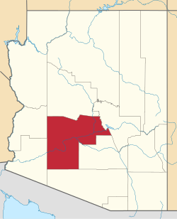
Counties Maricopa and Pinal
Elevation
1,421 ft (433 m)
Time zone UTC-7 (Mountain (MST))
ZIP code
85227
Area code 480
GNIS feature ID2749 [1]

Chandler Heights was a census-designated place and is an unincorporated community in Maricopa and Pinal counties, Arizona, United States. It is 11 miles southeast of Chandler. Formerly, Chandler Heights had a ZIP code of 85227, but it has since been abolished, and the United States Postal Service now uses "Queen Creek" for all Chandler Heights addresses.

Much of Chandler Heights is located within the planning boundaries of the town of Queen Creek for future annexation, with a small portion (west of Recker Rd) extending into the planning boundaries of the town of Gilbert.

History

The population of Chandler Heights was 75 in the 1960 census. [2]

Related Research Articles

<span class="mw-page-title-main">Maricopa County, Arizona</span> County in Arizona, United States

Maricopa County is in the south-central part of the U.S. state of Arizona. As of the 2020 census the population was 4,420,568, or about 62% of the state's total, making it the fourth-most populous county in the United States, the most populous county in Arizona, and making Arizona one of the nation's most centralized states. The county seat is Phoenix, the state capital and fifth-most populous city in the United States.

<span class="mw-page-title-main">Chandler, Arizona</span> City in Arizona, United States

Chandler is a city in Maricopa County, Arizona, United States, and a suburb in the Phoenix-Mesa-Chandler Metropolitan Statistical Area (MSA). It is bordered to the north and west by Tempe, to the north by Mesa, to the west by Phoenix, to the south by the Gila River Indian Community, and to the east by Gilbert. As of the 2021 census, the population of Chandler was 279,458, up from 236,123 at the 2010 census.

<span class="mw-page-title-main">Gilbert, Arizona</span> Town in Maricopa County, Arizona

Gilbert is a town in Maricopa County, Arizona, United States, located southeast of Phoenix within the city's metropolitan area. Incorporated on July 6, 1920, Gilbert was once known as the "Hay Shipping Capital of the World". It is the fifth-largest municipality in Arizona, and the fourth-largest in the Phoenix metro area. It covers an area of nearly 69 square miles (179 km2).

<span class="mw-page-title-main">Mesa, Arizona</span> City in Arizona, United States

Mesa is a city in Maricopa County, in the U.S. state of Arizona. It is the most populous city in the East Valley section of the Phoenix Metropolitan Area. It is bordered by Tempe on the west, the Salt River Pima-Maricopa Indian Community on the north, Chandler and Gilbert on the south along with Queen Creek, and Apache Junction on the east.

<span class="mw-page-title-main">Queen Creek, Arizona</span> Town in Maricopa and Pinal counties, Arizona

Queen Creek is a town in Maricopa and Pinal counties in the state of Arizona. The population was 59,519 as of the 2020 census, up from 26,361 at the 2010 census. It is a suburb of Phoenix, Arizona located in the far southeast area of the Phoenix metropolitan area. In 2023, a large battery factory was scheduled for 2025.

<span class="mw-page-title-main">Glendale Heights, Illinois</span> Village in Illinois, United States

Glendale Heights is a village in DuPage County, Illinois, United States. Per the 2020 census, the population was 33,176. The village is almost entirely residential, and is a far west suburb of Chicago.

<span class="mw-page-title-main">Berwyn Heights, Maryland</span> Town in Maryland

Berwyn Heights is a town in Prince George's County, Maryland, United States. Per the 2020 census, the population was 3,345. It is bordered by College Park to the west, Greenbelt to the northeast, and Riverdale Park to the south.

<span class="mw-page-title-main">Dearborn Heights, Michigan</span> City in Michigan, United States

Dearborn Heights is a city in Wayne County in the U.S. state of Michigan. With a population of 63,292 at the 2020 census., Dearborn Heights is part of the Detroit metropolitan area, and is considered a bedroom community.

<span class="mw-page-title-main">Phoenix metropolitan area</span> Metropolitan area in Arizona, United States

The Phoenix Metropolitan Area – also the Valley of the Sun, the Salt River Valley, or Metro Phoenix – is the largest metropolitan statistical area in the Southwestern United States, centered on the city of Phoenix, that includes much of the central part of Arizona. The United States Office of Management and Budget designates the area as the Phoenix-Mesa-Chandler Metropolitan Statistical Area (MSA), defining it as Maricopa and Pinal counties. It anchors the Arizona Sun Corridor megaregion along with the second most populous metropolitan area in the state, the Tucson metropolitan area. The gross domestic product of the Phoenix Metropolitan Area was $255 billion in 2018, 16th largest amongst metro areas in the United States.

Arizona's 6th congressional district is a congressional district located in the U.S. state of Arizona and encompasses all of Greenlee County, most of Cochise County, and parts of Pima County, Pinal County and Graham County. Most of its population resides in suburbs of Tucson, including Oro Valley, Marana, Green Valley, and Vail. The district is currently represented by Republican Juan Ciscomani. It was one of 18 districts that voted for Joe Biden in the 2020 presidential election while being won or held by a Republican in 2022.

Arizona's 5th congressional district is a congressional district located in the U.S. state of Arizona, currently represented by Republican Andy Biggs.

<span class="mw-page-title-main">Bumble Bee, Arizona</span> Ghost town in Yavapai County, Arizona

Bumble Bee is a ghost town in the Bradshaw Mountains of Yavapai County, Arizona, United States, named for nearby Bumble Bee Creek. The townsite area is commonly used by RV campers in winter.

Queen Anne in Prince George's County, Maryland, United States, is a former port on the Patuxent River. It was delineated as a CDP for the 2010 census, at which time it had a population of 1,280. Per the 2020 census, the population was 1,405.

<span class="mw-page-title-main">Drake, Arizona</span> Unincorporated community in the state of Arizona, United States

Drake was an unincorporated community on the Verde River in Yavapai County, Arizona, United States, and a station on the BNSF Railway's Phoenix Subdivision. Drake is also the junction and western terminus of the Verde Canyon Railroad. Drake is the site of the old Hell Canyon Bridge, formerly used by US Route 89, and now on the National Register of Historic Places.

Queen Creek Unified School District (QCUSD) is a school district based in Queen Creek, Arizona, United States. It was formed in 1947 from land once part of the Higley Unified School District (at the time, neither district was unified; Queen Creek High School would not open until 1967).

<span class="mw-page-title-main">San Tan Valley, Arizona</span> Unincorporated community in the state of Arizona, United States

San Tan Valley is an unincorporated community and census-designated place in northern Pinal County, Arizona, United States. With 99,894 residents as of the 2020 census, San Tan Valley is the largest unincorporated municipality in Pinal County.

Many arterial roads in the Phoenix metropolitan area have the same name in multiple cities or towns. Some roads change names or route numbers across town borders, resulting in occasional confusion. For example, the road known as Apache Boulevard in Tempe continues east as Main Street in neighboring Mesa and then as Apache Trail in Apache Junction. Although Broadway Road maintains the same name through Goodyear, Avondale, Phoenix, Tempe, Mesa, and Apache Junction, each town uses a different reference point for address numbers.

<span class="mw-page-title-main">East Valley (Phoenix metropolitan area)</span> Part of Metropolitan Phoenix in Arizona

The Phoenix Metropolitan Area consists of a valley that has multiple city regions in it. The East Valley is a multi-city region within the Phoenix Metropolitan Area of Arizona. East Valley is a loosely defined region, with differing definition of what constitutes it.

<span class="mw-page-title-main">Front Range urban corridor</span> Megaregion in Colorado and Wyoming, United States

The Front Range Urban Corridor is an oblong region of urban population located along the eastern face of the Southern Rocky Mountains, encompassing 18 counties in the US states of Colorado and Wyoming. The corridor derives its name from the Front Range, the mountain range that defines the western boundary of the corridor which serves as a gateway to the Rocky Mountains. The region comprises the northern portion of the Southern Rocky Mountain Front geographic area, which in turn comprises the southern portion of the Rocky Mountain Front geographic area of Canada and the United States. The Front Range Urban Corridor had a population of 5,055,344 at the 2020 Census, an increase of +16.65% since the 2010 Census.

References

  1. U.S. Geological Survey Geographic Names Information System: Chandler Heights, Arizona
  2. "Arizona". World Book Encyclopedia. Vol. A. Chicago: Field Enterprises Educational Corporation. 1960. p. 557.