Sunflower, Arizona

Last updated

Sunflower, Arizona
Maricopa County Incorporated and Planning areas Sunflower location.svg
Location of Sunflower in Maricopa County, Arizona
USGS map of Sunflower mining district 1915.jpg
USGS map of Sunflower Mining District (1915)
Coordinates: 33°51′51″N111°28′03″W / 33.86417°N 111.46750°W / 33.86417; -111.46750
Country United States
State Arizona
County Maricopa
Elevation
3,405 ft (1,038 m)
Time zone UTC-7 (Mountain (MST))
Area code 480
GNIS feature ID34951 [1]

Sunflower is a region of Maricopa County, Arizona, United States adjacent to the Mazatzal Wilderness, west of Tonto National Forest and northwest of Roosevelt Reservoir. Formerly a mercury-mining district, Sunflower is now a destination for hikers, campers and off-road vehicle tours. Sunflower is located near Arizona State Route 87, 22.8 miles (36.7 km) northeast of Fountain Hills. Route 87 near Sunflower is called the Beeline Highway.

Contents

History

The place name derives from Sunflower Camp, Sunflower Cinnabar Mining Co. and Sunflower Mining District, all established after E. H. Bowman of Phoenix found quicksilver deposits in the area in October 1911 while prospecting for gold. [2] These, in turn, draw their names from the pre-existing Sunflower ranch. [2] [3] The mercury deposits of the Mazatzal mountains—especially Sunflower, Pine Mountain and Rattlesnake mines—were the source of 95 percent of all mercury extracted from Arizona. [4]

Circa 1915, visitors to the Tonto National Forest were advised that park rangers could be found at Sunflower. [5] The location was a raw campsite until the 1930s, when Captain Harold Booth led Civilian Conservation Corp cohorts to the area. [6] The Sunflower Ranch CCC camp was site F-25-A. [7] Sunflower Ranger Station was built by the CCC in 1933 and was added to the National Register of Historic Places in 1993. [8]

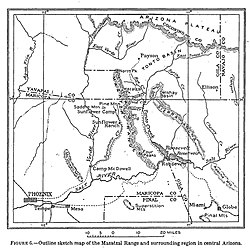
Prior to the establishment of the Sunflower post office in 1945, the post office location was sometimes called Diamond Ranch. [9] Bushnell Tank near Sunflower was a watering stop built by the Forest Service and sheepmen along the Heber–Reno Sheep Driveway; the water in tank was piped in from a mountain spring and was located three days from the previous watering station. [10]

The location saw flooding during when the remnants of Tropical Storm Norma hit the area in 1970. [11] This flood destroyed Sycamore Bridge between Sunflower and Payson, washing away a state highway patrol car and killing the patrolman. [12]

The mine was abandoned in the 1980s but the site, accessible via the "often rough and boulder-strewn Sunflower Mine trail" remained an attraction for hikers. [13] Circa 1987, Sunflower was to be a rest stop on the planned Trans-Arizona Trail but the Sunflower store had burned down so another provision site would have to be established. [14] Sunflower is the junction point between sections 21 and 22 of the Arizona National Scenic Trail. [15] [16]

According to video evidence presented at trial, the Viper Militia practiced using explosives at Sunflower, [17] reportedly eventually blowing up a bridge over the west fork of Sycamore Creek. [18] In 1997, when the refining equipment necessary to extract mercury from cinnabar remained standing at the site above the Sycamore Creek, the Arizona Republic said the Sunflower trails offer "a look at the harshness of mining life and the ingenuity that was needed to erect mining facilities in rough terrain." [18] Prior to road improvements in 1998, the road between the "hamlets" of Sunflower and Sycamore Creek was described as a "white-knuckle crapshoot [of] steep, twisting curves hugging the side of a mountain." [19]

The community was evacuated in 2005 due to the threat of a nearby fire. [20] In 2012, the Sunflower Fire burned 18,000 acres (28 sq mi; 73 km2; 7,300 ha); the fire was started by an incendiary shotgun shell fired at a bachelor-party camping trip. [21] [22]

Related Research Articles

<span class="mw-page-title-main">Payson, Arizona</span> Town in Gila County, Arizona

Payson is a town in northern Gila County, Arizona, United States. Due to Payson's location being very near to the geographic center of Arizona, it has been called "The Heart of Arizona". The town is surrounded by the Tonto National Forest, the largest of the six national forests in Arizona and the ninth largest national forest in the United States.[1][2]

<span class="mw-page-title-main">Superstition Mountain</span> Landform in Arizona, United States

Superstition Mountain is a prominent mountain and regional landmark located in the Phoenix metropolitan area of Arizona, immediately east of Apache Junction and north of Gold Canyon. It anchors the west end of the Superstition Mountains and is a popular outdoor recreation destination, home to numerous trails for hiking and horseback riding. The legend of the Lost Dutchman's Gold Mine centers around the mountain.

<span class="mw-page-title-main">Tonto National Forest</span> Protected area in Arizona

The Tonto National Forest, encompassing 2,873,200 acres, is the largest of the six national forests in Arizona and is the ninth largest national forest in the United States. The forest has diverse scenery, with elevations ranging from 1,400 feet in the Sonoran Desert to 7,400 feet in the ponderosa pine forests of the Mogollon Rim. The Tonto National Forest is also the most visited "urban" forest in the United States.

<span class="mw-page-title-main">Almaden Valley, San Jose</span> Neighborhood of San Jose, California, U.S.

Almaden Valley, commonly known simply as Almaden, is a valley and neighborhood of San Jose, California, located in South San Jose. It is nestled between the Santa Cruz Mountains to the west and the Santa Teresa Hills to the east, bordering the town of Los Gatos and West San Jose neighborhood.

<span class="mw-page-title-main">Phoenix Mountains</span> Mountain range in the Southwestern United States

The Phoenix Mountains are a mountain range located in central Phoenix, Arizona. With the exception of Mummy Mountain, they are part of the Phoenix Mountain Preserve. They serve as a municipal park and offer hiking, mountain biking and equestrian trails at a variety of different access points.

<span class="mw-page-title-main">Tonto Apache</span> Western Apache Indigenous people

The Tonto Apache is one of the groups of Western Apache people and a federally recognized tribe, the Tonto Apache Tribe of Arizona. The term is also used for their dialect, one of the three dialects of the Western Apache language.

<span class="mw-page-title-main">Coconino National Forest</span> United States protected area in Arizona

The Coconino National Forest is a 1.856-million acre United States National Forest located in northern Arizona in the vicinity of Flagstaff, with elevations ranging from 2,600 feet to the highest point in Arizona at 12,633 feet. Originally established in 1898 as the "San Francisco Mountains National Forest Reserve", the area was designated a U.S. National Forest by Pres. Theodore Roosevelt on July 2, 1908, when the San Francisco Mountains National Forest Reserve was merged with lands from other surrounding forest reserves to create the Coconino National Forest. Today, the Coconino National Forest contains diverse landscapes, including deserts, ponderosa pine forests, flatlands, mesas, alpine tundra, and ancient volcanic peaks. The forest surrounds the towns of Sedona and Flagstaff and borders four other national forests; the Kaibab National Forest to the west and northwest, the Prescott National Forest to the southwest, the Tonto National Forest to the south, and the Apache-Sitgreaves National Forest to the southeast. The forest contains all or parts of nine designated wilderness areas, including the Kachina Peaks Wilderness, which includes the summit of the San Francisco Peaks. The headquarters are in Flagstaff. The Coconino National Forest consists of three districts: Flagstaff Ranger District, Mogollon Rim Ranger District, and Red Rock Ranger District, which have local ranger district offices in Flagstaff, Happy Jack, and Sedona.

<span class="mw-page-title-main">New Almaden</span> Neighborhood of San Jose in Santa Clara, California, United States

New Almaden, known in Spanish as Nueva Almadén, is a historic community and former mercury mine in the Capitancillos Hills of San Jose, California, located at the southwestern point of Almaden Valley in South San Jose. New Almaden is divided into two parts: the mines and much of their immediate surroundings, including historic ghost town settlements in the Capintancillas, which together form the Almaden Quicksilver County Park, and the largely residential historic district surrounding the Casa Grande.

<span class="mw-page-title-main">Sierra Ancha</span> Mountain range in Gila County, Arizona

The Sierra Ancha is a mountain range in Gila County, in central Arizona. It lies between Roosevelt Lake to the south, the Tonto Basin to the west, Cherry Creek to the east, and Pleasant Valley to the north. The range is one of several, including the Bradshaw Mountains, Mingus Mountain of the Black Hills, and the Mazatzal Mountains, which form a transitional zone between the lowland deserts of southern Arizona and the Colorado Plateau of northeastern Arizona. The highest point in the range is Aztec Peak, at an elevation of 2345 m (7694 ft).

<span class="mw-page-title-main">Four Peaks</span> Landform near Phoenix, Arizona

Four Peaks is a prominent landmark on the eastern skyline of Phoenix. Part of the Mazatzal Mountains, it is located in the Four Peaks Wilderness in the Tonto National Forest, 40 miles (64 km) east-northeast of Phoenix. In winter, Four Peaks offers much of the Phoenix metro area a view of snow-covered peaks. Four Peaks is the site of an amethyst mine that produces top-grade amethyst.

<span class="mw-page-title-main">Kentucky Camp, Arizona</span> United States historic place

Kentucky Camp is a ghost town and former mining camp along the Arizona Trail in Pima County, Arizona, United States, near the community of Sonoita. The Kentucky Camp Historic District is listed on the National Register of Historic Places and has been since 1995. As it is located within Coronado National Forest, the United States Forest Service is responsible for the upkeep of the remaining buildings within the Kentucky Camp Historic District.

<span class="mw-page-title-main">Theodore Roosevelt Lake</span> Reservoir on the Salt River, Gila County, Arizona, US

Theodore Roosevelt Lake is a large reservoir formed by Theodore Roosevelt Dam on the Salt River in Arizona as part of the Salt River Project (SRP). Located roughly 80 miles (130 km) northeast of Phoenix in the Salt River Valley, Theodore Roosevelt is the largest lake or reservoir located entirely within the state of Arizona. The reservoir and the masonry dam that created it, Roosevelt Dam, were both named after U.S. President Theodore Roosevelt who dedicated the dam himself on March 18, 1911. Roosevelt Lake is a popular recreation destination within the Tonto National Forest; the facilities located at this lake are managed by that authority.

<span class="mw-page-title-main">Mazatzal Mountains</span> Landform in Arizona, United States

The Mazatzal Mountains are a mountain range in south central Arizona, about 30–45 miles northeast of the Phoenix metropolitan area. The origin of the name remains obscure but one possibility is that it is from the Nahuatl language meaning "place of the deer". The crest of the Mazatzals forms the county line between Maricopa County and Gila County. SR 87, the Beeline Highway, traverses the Mazatzals on its way to Payson. The highest peak is Mazatzal Peak at 7,903 feet (2,409 m). They also include the Four Peaks, with elevation 7,659 ft, 2,334 m; a prominent mountain and landmark of the eastern Phoenix area.

<span class="mw-page-title-main">Pinal City, Arizona</span> Ghost town in Pinal County, Arizona

Pinal or Pinal City is a ghost town in Pinal County in the U.S. state of Arizona. The town was populated from the 1870s into the 1890s, in what was then the Arizona Territory.

The Great Western Trail is a north-south long distance multiple use route that runs from Canada to Mexico through five western states in the United States. The trail has access for both motorized and non-motorized users and traverses 4,455 miles (7,170 km) through Arizona, Utah, Idaho, Wyoming, and Montana. It was designated a National Millennium Trail in 1999.

<span class="mw-page-title-main">Sunflower Ranger Station</span> United States historic place

The Sunflower Ranger Station, also known as Sunflower Administrative Site or Sycamore Ranger Station, in Tonto National Forest in the Sunflower district near Punkin Center, Arizona was built in 1935 by the Civilian Conservation Corps. It was listed on the National Register of Historic Places in 1993 for its architecture, which is Bungalow/Craftsman in style. It served historically as institutional housing and as government office space. The listing included two contributing buildings.

Mazatzal Wilderness is a wilderness area of about 390 square miles (1,000 km2) in Yavapai and Gila counties in the U.S. state of Arizona. The wilderness is within the Tonto and Coconino national forests. The town of Payson is to the east, and the Verde River is to the west. During summer, temperatures in the wilderness often exceed 110 °F (43 °C).

<span class="mw-page-title-main">Pinal Mountains</span> Landform in Gila County, Arizona

The Pinal Mountains are a mountain range located in Gila County, Arizona. They have a maximum elevation of 7,848 ft (2,392 m) at Pinal Peak and a prominence of over 4,000 ft (1,200 m). The closest city is the Globe, Arizona/Miami, Arizona area, which is just a few miles north of the mountain range. The mountains are located within the Tonto National Forest, and their recreational facilities are maintained by the USDA's United States Forest Service. The San Carlos Indian Reservation is very close to the mountain range, with its boundaries being just a few miles east/northeast of the range. The mountains are covered with Ponderosa Pine and white fir and experience cooler weather than the Globe/Miami area, so that they are a popular recreation area in the summer. The maintained facilities include a maintained dirt road that goes all the way to the summit of Pinal Peak, a campsite and recreational area, many hiking trails, as well as some radio towers near both Pinal and Signal peaks. The mountain range covers an area of 45,760 acres.

<span class="mw-page-title-main">Cinnabar, Queensland</span> Suburb of Gympie Region, Queensland, Australia

Cinnabar is a rural locality in the Gympie Region, Queensland, Australia. In the 2016 census, Cinnabar had a population of 72 people.

<span class="mw-page-title-main">Pinto Creek (Arizona)</span> River in Arizona, United States

Pinto Creek is a tributary of the Salt River in Gila County, Arizona, within the Tonto National Forest. The creek winds for 28 miles (45 km) northward from the Pinal Mountains, through the Sonoran Desert, before emptying into the tail of Theodore Roosevelt Lake. Since the 1980s, the Pinto Creek watershed has been the site of environmental disputes over water rights and mining operations.

References

  1. U.S. Geological Survey Geographic Names Information System: Sunflower, Arizona
  2. 1 2 Ransome, F.L. (1915). "QUICKSILVER DEPOSITS OF THE MAZATZAL RANGE, ARIZONA" (PDF). Contributions to Economic Geology. U.S. Geological Survey: 111–128.
  3. "Roosevelt Quadrangle 1908 Arizona Historical Topographic Maps". Perry-Castañeda Map Collection - UT Library Online. Retrieved March 13, 2023.
  4. Ascarza, William. "Mine Tales: Arizona was "mad as a hatter" for mercury mining". Arizona Daily Star. Retrieved March 14, 2023.
  5. "Tonto National Forest, Arizona. 1915 Map Verso". Arizona Memory.
  6. "No Sunflower, Arizona, until camp arrives". Grand Junction Daily Sentinel. October 8, 1933.
  7. "Arizona Republic 11 May 1935, page Page 33". Newspapers.com. Retrieved March 14, 2023.
  8. Michael A. Sullivan (September 19, 2017). "National Register of Historic Places Registration: Sunflower Ranger Station / Sunflower Administrative Site / Sycamore Ranger Station". National Park Service . Retrieved March 13, 2017. with three photos from 1989
  9. "Record Group 28: Records of the Post Office Department Series: Reports of Site Locations Arizona: Gila - Maricopa and NAID: 68194344". archives.gov. Retrieved March 12, 2023.
  10. "Arizona Republic 16 May 1948, page Page 13". Newspapers.com. Retrieved March 14, 2023.
  11. "Bob Lindmeier's Weather Facts". The Capital Times. September 4, 2000.
  12. "Arizona Republic 07 Sep 1970, page Page 1". Newspapers.com. Retrieved March 14, 2023.
  13. "Sunflower Mine". AZOFFROAD.NET. Retrieved March 14, 2023.
  14. "Arizona Daily Sun 19 Feb 1987, page 11". Newspapers.com. Retrieved March 14, 2023.
  15. "Passage 21: Pine Mountain – Explore the Arizona Trail". aztrail.org. Retrieved March 14, 2023.
  16. "Passage 22: Saddle Mountain – Explore the Arizona Trail". aztrail.org. Retrieved March 14, 2023.
  17. "Arizona Republic 06 Jul 1996, page Page 27". Newspapers.com. Retrieved March 14, 2023.
  18. 1 2 Burkhart, Barry (February 27, 1997). "Abandoned mercury mine an adventure" . Arizona Republic . pp. OT4. Retrieved March 14, 2023 via Newspapers.com.
  19. Petrie, Bob (September 5, 1998). "New lanes on Beeline make drive bit safer". Arizona Republic. p. 1.
  20. "Wildfire threatens tiny town in southwestern Utah". Appleton Post-Crescent. July 23, 2005.
  21. ICT Staff (July 3, 2012). "Arizona Man Charged With Starting Sunflower Wildfire". ICT News. Retrieved March 14, 2023.
  22. Tsetsi, Eric. "Arizona's Sunflower Fire Continues Burning in Tonto National Forest (Photos)". Phoenix New Times. Retrieved March 14, 2023.