Apache Wells, Arizona

Last updated
Apache Wells, Arizona
Populated place
USA Arizona location map.svg
Red pog.svg
Apache Wells
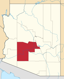
Location of Apache Wells in Arizona
Coordinates: 33°27′34″N111°42′39″W / 33.45944°N 111.71083°W / 33.45944; -111.71083
Country United States
State Arizona
County Maricopa
Area
  Total1 sq mi (3 km2)
Elevation
[1]
1,427 ft (435 m)
Time zone UTC-7 (Mountain (MST))
  Summer (DST) UTC-7 (MST)
ZIP codes
85205
Area code 480
FIPS code 04-02900
GNIS feature ID 36924

Apache Wells is the name of both fictional and real locations in southern Arizona.

Contents

Fictional Apache Wells

In fiction, particularly in Western movies, "Apache Wells" is a common name for a fictional location in the Old West, generally a remote stagecoach way station, typically in southern Arizona. It first came into conspicuous public use in John Ford's classic 1939 western movie Stagecoach, [2] the film that elevated John Wayne to stardom. (The film also had remakes in 1966 and 1986).

Subsequent westerns set partly, or chiefly, in or around the fictional "Apache Wells" have included:

At the time that the fictional "Apache Wells" first came into use, there was not any actual town of Apache Wells in Arizona, but there were two small, remote settlements in southern Arizona with closely related names: Apache Junction, and Desert Wells — both of which had existed since the 1800s, when they had been sites of stagecoach way stations.

Real Apache Wells

Today, Apache Wells is a populated place and retirement community situated within the boundaries of the city of Mesa (a major suburb of Phoenix, part of the Phoenix Metropolitan Area) in Maricopa County, in the state of Arizona, in the United States. [8] Apache Wells was established in 1962 and developed by the Hughes family. [9] It has an estimated elevation of 1,427 feet (435 m) above sea level, and is approximately one square mile in size.

Related Research Articles

<i>Stagecoach</i> (1939 film) American film by John Ford

Stagecoach is a 1939 American Western film directed by John Ford and starring Claire Trevor and John Wayne in his breakthrough role. The screenplay by Dudley Nichols is an adaptation of "The Stage to Lordsburg", a 1937 short story by Ernest Haycox. The film follows a group primarily composed of strangers riding on a stagecoach through dangerous Apache territory.

<span class="mw-page-title-main">Pinal County, Arizona</span> County in Arizona, United States

Pinal County is in the central part of the U.S. state of Arizona. According to the 2020 census, the population of the county was 425,264, making it Arizona's third-most populous county. The county seat is Florence. The county was founded in 1875.

<span class="mw-page-title-main">Apache Junction, Arizona</span> City in Arizona, United States

Apache Junction is a city in Pinal and Maricopa County, Arizona, United States. As of the 2020 census, the population was 38,499, most of whom lived in Pinal County. It is named for the junction of the Apache Trail and Old West Highway. The area where Apache Junction is located used to be known as Youngberg. Superstition Mountain, the westernmost peak of the Superstition Mountains, is to the east.

<span class="mw-page-title-main">Gila Bend, Arizona</span> Town in Maricopa County, Arizona

Gila Bend, founded in 1872, is a town in Maricopa County, Arizona, United States. The town is named for an approximately 90-degree bend in the Gila River, which is near the community's current location. As of the 2020 census, the population of the town was 1,892.

<span class="mw-page-title-main">New River, Arizona</span> CDP in Maricopa County, Arizona

New River is an unincorporated community and census-designated place (CDP) in Maricopa County, Arizona, United States. The population was 17,290 as of the 2020 census, up from 14,952 at the 2010 census.

<span class="mw-page-title-main">Salt River (Arizona)</span> River in Gila and Maricopa counties in Arizona, United States

The Salt River is a river in Gila and Maricopa counties in Arizona, United States, that is the largest tributary of the Gila River. The river is about 200 miles (320 km) long. Its drainage basin covers about 13,700 square miles (35,000 km2). The longest of the Salt River's many tributaries is the 195-mile (314 km) Verde River. The Salt's headwaters tributaries, the Black River and East Fork, increase the river's total length to about 300 miles (480 km). The name Salt River comes from the river's course over large salt deposits shortly after the merging of the White and Black Rivers.

<span class="mw-page-title-main">Phoenix metropolitan area</span> Metropolitan statistical area in Arizona, US

The Phoenix metropolitan area, also known as the Valley of the Sun, the Salt River Valley, metro Phoenix, or The Valley, is the largest metropolitan statistical area in the Southwestern United States, with its largest principal city being the city of Phoenix. It includes much of central Arizona. The United States Office of Management and Budget designates the area as the Phoenix–Mesa–Chandler Metropolitan Statistical Area (MSA), defining it as Maricopa and Pinal counties. It anchors the Arizona Sun Corridor megaregion along with the second-most populous metropolitan area in the state, the Tucson metropolitan area. The gross domestic product of the Phoenix metropolitan area was $255 billion in 2018, 16th highest amongst metro areas in the United States.

<span class="mw-page-title-main">Revisionist Western</span> Western film subgenre

The revisionist Western is a sub-genre of the Western film. Called a post-classical variation of the traditional Western, the revisionist subverts the myth and romance of the traditional by means of character development and realism to present a less simplistic view of life in the "Old West". While the traditional Western always embodies a clear boundary between good and evil, the revisionist Western does not.

<span class="mw-page-title-main">Frank McGrath (actor)</span> American actor and stunt performer (1903–1967)

Benjamin Franklin "Frank" McGrath was an American television and film actor and stunt performer who played the comical, optimistic cook with the white beard, Charlie B. Wooster, on the western series Wagon Train for five seasons on NBC and then three seasons on ABC. McGrath appeared in all 272 episodes in the eight seasons of the series, which had ended its run only two years before his death. McGrath's Wooster character hence provided the meals and companionship for both fictional trail masters, Ward Bond as Seth Adams and John McIntire as Christopher "Chris" Hale.

Arizona's 1st congressional district is a congressional district located in the U.S. state of Arizona, covering northeastern Maricopa County. Before 2023, geographically, it was the eleventh-largest congressional district in the country and included much of the state outside the Phoenix and Tucson metropolitan areas. From 2013 through 2022, it also included the Navajo Nation, the Hopi reservation, and the Gila River Indian Community, with 25% of the population being Native American. At that time, the district had more Native Americans than any other congressional district in the United States. In the 2022 elections, David Schweikert was elected in the redefined district. It was one of 18 districts that would have voted for Joe Biden in the 2020 presidential election had they existed in their current configuration while being won or held by a Republican in 2022.

<span class="mw-page-title-main">Battle of Stanwix Station</span> Westernmost skirmish of the American Civil War

Stanwix Station, in western Arizona, was a stop on the Butterfield Overland Mail Stagecoach line built in the later 1850s near the Gila River about 80 miles (130 km) east of Yuma, Arizona. Originally the station was called Flap Jack Ranch later Grinnell's Ranch or Grinnell's Station. In 1862, Grinnell's was listed on the itinerary of the California Column in the same place as Stanwix Ranch which became the site of the westernmost skirmish of the American Civil War. A traveler in 1864, John Ross Browne, wrote Grinnell's was six miles southwest of the hot springs of Agua Caliente, Arizona.

Arizona's 2nd congressional district is a congressional district located in the U.S. state of Arizona. The district is in the north eastern part of the state and includes Apache, Coconino, Gila, Navajo, and Yavapai counties in their entirety and portions of Graham, Maricopa, Mohave, and Pinal counties. The largest city in the district is Flagstaff.

<span class="mw-page-title-main">Maricopa station</span> Train station in Maricopa, Pinal County, Arizona

Maricopa station is an Amtrak train station in Maricopa, Arizona, United States, serving Phoenix and central Arizona. The station accommodates travelers who use the combined Sunset Limited and Texas Eagle, which operates three times per week in each direction between Los Angeles and Chicago or New Orleans. Amtrak Thruway service is available between Maricopa station, Tempe station and Phoenix Sky Harbor International Airport.

<span class="mw-page-title-main">Ben Cooper</span> American actor (1933–2020)

Ben Cooper was an American actor of film and television who won a Golden Boot Award in 2005 for his work in westerns.

<span class="mw-page-title-main">Maricopa Wells, Arizona</span> Locale in Arizona, United States

Maricopa Wells is a former place (locale) situated in Pinal County, Arizona. It has an estimated elevation of 1,093 feet (333 m) above sea level. Historically, it was an oasis around a series of watering holes in the Sierra Estrella, eight miles north of present-day Maricopa, Arizona, and about a mile west of Pima Butte. It developed as a trading center and stopping place for travelers in the mid to late 19th century.

<span class="mw-page-title-main">Gillett, Arizona</span> Ghost town in Yavapai County, Arizona

Gillett, Arizona, is a ghost town in Yavapai County, Arizona, United States. It has an estimated elevation of 1,362 feet (415 m) above sea level. Historically, it was a stagecoach station, and then a settlement formed around an ore mill serving the Tip Top Mine, on the Agua Fria River in Yavapai County in what was then Arizona Territory. It was named for the mining developer of the Tip Top Mine, Dan B. Gillett and is spelled incorrectly as Gillette on U. S. Topographic Maps and elsewhere.

Heaton is a populated place situated in Pinal County, Arizona, United States. It has an estimated elevation of 1,197 feet (365 m) above sea level.

<span class="mw-page-title-main">Sacate, Arizona</span> Pima village, railroad siding, Catholic mission

Sacate is a populated place in the Middle Gila River Valley area, within Pinal County, Arizona, United States. Located 8 mi (13 km) north of Maricopa on the south side of the Gila River near Pima Butte, Sacate was an Pima village, a railroad station of the Southern Pacific Railroad, and a Catholic mission. It had originally been called Sacaton Station but the name was shortened to its current version in 1904.

Sundad is an unincorporated area in the far west of Maricopa County, Arizona, United States, along the border of Yuma County. It has an estimated elevation of 965 feet (294 m) above sea level. It is located north of Agua Caliente and east of Sacation Flats.

References

  1. "Feature Detail Report for: Apache Wells". Geographic Names Information System . United States Geological Survey, United States Department of the Interior.
  2. Bandy, Mary Lea; and Kevin Stoehr: "The Big Trail and Stagecoach," Oct 1, 2012, in Ride, Boldly Ride: The Evolution of the American Western, p.95, University of California Press, retrieved February 16, 2022
  3. "Duel at Apache Wells: 1957", Internet Movie Database, retrieved February 16, 2022
  4. Chennault, Nicholas: "Apache Territory," February 9, 2015, in "Great Western Movies," retrieved February 16, 2022
  5. "Rampage at Apache Wells: 1966," Turner Classic Movies, retrieved February 16, 2022
  6. "40 Guns to Apache Pass: 1967," Internet Movie Database, retrieved February 16, 2022
  7. "40 Guns to Apache Pass (1967); Plot," Internet Movie Database, retrieved February 16, 2022
  8. "Apache Wells (in Maricopa County, AZ) Populated Place Profile". AZ Hometown Locator. Retrieved January 8, 2016.
  9. "Apache Wells HOA - History of Apache Wells" . Retrieved 2021-11-12.