Maricopa Colony, Arizona | |
|---|---|
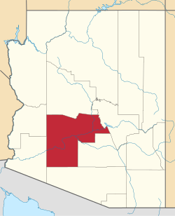
 Location in Maricopa County, Arizona | |
| Coordinates: 33°22′35″N112°14′22″W / 33.37639°N 112.23944°W | |
| Country | United States |
| State | Arizona |
| County | Maricopa |
| Area | |
• Total | 5.49 sq mi (14.21 km2) |
| • Land | 5.49 sq mi (14.21 km2) |
| • Water | 0.00 sq mi (0.00 km2) |
| Elevation | 991 ft (302 m) |
| Population | |
• Total | 854 |
| • Density | 155.70/sq mi (60.12/km2) |
| Time zone | UTC-7 (MST (no DST)) |
| ZIP code | 85339 [4] |
| Area code | 520 |
| FIPS code | 04-44450 |
| GNIS feature ID | 2612141 [2] |
Maricopa Colony is a census-designated place (CDP) in Maricopa County, Arizona, United States, located in the federally recognized Gila River Indian Community. The population was 854 at the 2020 census, [3] up from 709 at the 2010 census. It is located on the southern side of the Phoenix metropolitan area, around Baseline Road and 83rd Avenue.


