Kaka, Arizona O'odham: Gagka | |
---|---|
Coordinates: 32°30′41″N112°18′59″W / 32.51139°N 112.31639°W | |
Country | United States |
State | Arizona |
County | Maricopa |
Area | |
• Total | 0.50 sq mi (1.29 km2) |
• Land | 0.50 sq mi (1.29 km2) |
• Water | 0.00 sq mi (0.00 km2) |
Elevation | 2,251 ft (686 m) |
Population | |
• Total | 83 |
• Density | 167.00/sq mi (64.48/km2) |
Time zone | UTC-7 (MST (no DST)) |
Area code | 928 |
FIPS code | 04-36780 |
GNIS feature ID | 2582804 [2] |
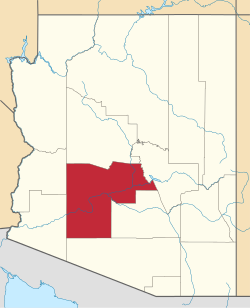
Kaka (O'odham: Gagka, translates as "A Clearing") is a census-designated place (CDP) in Maricopa County, Arizona, United States, located in the Tohono O'odham Nation. The population was 83 at the 2020 census, [3] down from 141 at the 2010 census.
It has frequently been noted on lists of unusual place names. [4]
Kaka is in southernmost Maricopa County, nearly touching the border with Pima County. It is 88 miles (142 km) south-southwest of Phoenix, 106 miles (171 km) west-northwest of Tucson, and 67 miles (108 km) northeast of the Mexican border at Lukeville.
At the 2020 census there were 83 people and 28 households living in the CDP. [3] [5]
The median household income was $39,573. The per capita income for the CDP was $13,965. [6]
Census | Pop. | Note | %± |
---|---|---|---|
2010 | 141 | — | |
2020 | 83 | −41.1% | |
U.S. Decennial Census [7] |
As of the census [8] of 2010, there were 141 people living in the CDP. The population density was 545.0 people per square mile. The racial makeup of the CDP was 99% Native American and 1% from some other race. 6% of the population were Hispanic or Latino of any race.
Rio Verde is a master-planned community just east of Scottsdale, in Arizona. It is also a census-designated place (CDP) in Maricopa County, Arizona, United States, located in the far, far northeast area of the whole Phoenix Metropolitan Area. The population was 2,210 as of the 2020 census, up from 1,811 at the 2010 census.
Sun Lakes is an unincorporated community and census-designated place (CDP) in Maricopa County, Arizona, United States. The population was 14,868 at the 2020 census. Sun Lakes is an active adult community comprising five country club communities in three homeowner associations. These include the gated communities of Oakwood and IronWood (IronOaks), the gated and non-gated communities of Palo Verde and Cottonwood, and the non-gated community of Sun Lakes 1. Sun Lakes is a master-planned community developed by Robson Communities.
Mojave Ranch Estates is an unincorporated community and census-designated place (CDP) in Mohave County, Arizona, United States. The population was 53 as of the 2020 census.
Country Club is a suburban census-designated place located in northwest Miami-Dade County, Florida, United States. It is located in the Miami metropolitan area of South Florida. The CDP is named after the Country Club of Miami, which was established in 1961 in what was then an unpopulated and undeveloped section of the county. The population was 49,967 at the 2020 census, up from 3,408 in 1990.
Ives Estates is a census-designated place (CDP) in Miami-Dade County, Florida. It is part of the Miami metropolitan area of South Florida. The population was 25,005 at the 2020 census, up from 19,525 in 2010.
Kendall West is a census-designated place and unincorporated community in Miami-Dade County, Florida, west of the Florida Turnpike. It is located in the Miami metropolitan area of South Florida. The population was 36,536 at the 2020 census.
Leisure City is an unincorporated community and census-designated place (CDP) in Miami-Dade County, Florida, United States, that includes the smaller, older community of Modello in its northwestern section. The CDP is most notable for the Coral Castle Museum, located in the Modello area. It is located in the Miami metropolitan area of South Florida. The population was 26,324 at the 2020 census, up from 22,655 in 2010.
Palmetto Estates is an unincorporated area and census-designated place (CDP) in Miami-Dade County, Florida, United States. It is part of the Miami metropolitan area of South Florida. The population was 13,498 at the 2020 census.
Richmond Heights is a census-designated place (CDP) in Miami-Dade County, Florida, United States. It is part of the Miami metropolitan area of South Florida. The population was 8,944 at the 2020 census.
The Hammocks is a planned community and census-designated place in Miami-Dade County, Florida, United States. It is part of the Miami metropolitan area of South Florida. The population was 59,480 at the 2020 census, up from 51,003 in 2010.
Three Lakes is a census-designated place (CDP) and planned community in Miami-Dade County, Florida, United States. It is part of the Miami metropolitan area of South Florida. The population was 16,540 at the 2020 census, up from 15,047 in 2010.
West Perrine is a census-designated place (CDP) in Miami-Dade County, Florida, United States. It is part of the Miami metropolitan area of South Florida. The population was 10,602 at the 2020 census, up from 9,460 in 2010.
Westview is a census-designated place (CDP) in Miami-Dade County, Florida, United States. It is part of the Miami metropolitan area of South Florida. The population was 9,923 at the 2020 census.
Venetian Village is a census-designated place (CDP) in Lake County, Illinois, United States. Per the 2020 census, the population was 2,761.
South Miami Heights is a census-designated place (CDP), originally known as Eureka, in Miami-Dade County, Florida. It is part of the Miami metropolitan area of South Florida. The population was 36,770 as of the 2020 census.
Aguila is an unincorporated community and census-designated place (CDP) in Maricopa County, Arizona, United States. It is located on U.S. Route 60, 25 miles (40 km) west of Wickenburg and 22 miles (35 km) northeast of Wenden. Major economic activities include cantaloupe farming and formerly included mining. It uses the same street numbering system as Phoenix. As of the 2020 census, the population of Aguila was 565, down from 798 in 2010.
Arlington is an unincorporated community and census-designated place (CDP) in Maricopa County, Arizona, United States, located 43 miles (69 km) west of downtown Phoenix on old U.S 80. It follows the street numbering system of Phoenix. As of the 2020 census, the population was 150, down from 194 at the 2010 census.
Komatke is a census-designated place in Maricopa County, Arizona, United States. The area currently comprising the census-designated place had a population of 1,013 at the 2020 census, up from 821 at the 2010 census. It is located within the Gila River Indian Community. Its name refers to the Sierra Estrella mountain range, which rises just to the southwest of Komatke.
Gila Crossing is a census-designated place (CDP) in Maricopa County, Arizona, United States, within the Gila River Indian Community south of Komatke. The population was 636 at the 2020 census.
St. Johns is a census-designated place (CDP) in Maricopa County, Arizona, United States, located in the Gila River Indian Community. The population was 690 at the 2020 census, up from 476 at the 2010 census.