Demographics
Historical population| Census | Pop. | Note | %± |
|---|
| 2000 | 10,740 | | — |
|---|
| 2010 | 14,952 | | 39.2% |
|---|
| 2020 | 17,290 | | 15.6% |
|---|
|
As of the census of 2000, there were 10,740 people, 3,921 households, and 3,066 families residing in the CDP. The population density was 151.6 inhabitants per square mile (58.5/km2). There were 4,514 housing units at an average density of 63.7 per square mile (24.6/km2). The racial makeup of the CDP was 95.9% White, 0.4% Black or African American, 0.6% Native American, 0.5% Asian, 0.1% Pacific Islander, 1.3% from other races, and 1.4% from two or more races. 4.9% of the population were Hispanic or Latino of any race.
There were 3,921 households, out of which 35.3% had children under the age of 18 living with them, 68.9% were married couples living together, 5.6% had a female householder with no husband present, and 21.8% were non-families. 15.3% of all households were made up of individuals, and 2.9% had someone living alone who was 65 years of age or older. The average household size was 2.73 and the average family size was 3.04.
In the CDP, the population was spread out, with 26.0% under the age of 18, 4.8% from 18 to 24, 33.2% from 25 to 44, 28.5% from 45 to 64, and 7.5% who were 65 years of age or older. The median age was 38 years. For every 100 females, there were 103.9 males. For every 100 females age 18 and over, there were 102.4 males.
The median income for a household in the CDP was $62,307, and the median income for a family was $68,604. Males had a median income of $46,361 versus $31,610 for females. The per capita income for the CDP was $25,932. About 3.6% of families and 5.7% of the population were below the poverty line, including 5.5% of those under age 18 and 3.1% of those age 65 or over.
As of the census of 2010 the population of the New River CDP area was 14,952. This is nearly a two thirds growth from the previous census. The total housing units nearly doubled from 3,921 in 2000 to 6,753 in 2010. [7]
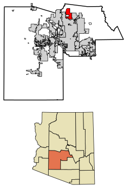
New River CDP area is within Maricopa County District 3. According to 2010 census numbers, the New River CDP consists of about 2% of Maricopa County District 3 and only 0.3% of Maricopa County. [8]
Government
New River is served by Deer Valley Unified School District.
Fire and emergency service is provided through the Daisy Mountain Fire District. [9]
Many residents previously relied on water delivered by state-licensed water haulers from fire hydrants located in Phoenix. As of August 2018, water is hauled from a filling station operated by Epcor. [10] [11]
Incorporation efforts
New River, and its neighbor Desert Hills, are unincorporated areas in Maricopa County which in 2019 was named the fastest-growing county in the United States for the third year running. While parts of Maricopa have had considerable development, New River has held off. New River has attempted to "incorporate" a number of times in its history, so as to control zoning regulations and development in the area. [12]
- In 1979 the area tried to incorporate into a town, and while the necessary signatures were collected to move forward with incorporation, the Maricopa County Superior Court Judge vacated the election, finding that New River was too rural and did not meet the statutory requirements for incorporation. At this time, Phoenix was approximately 30 miles (48 km) away. [13]
- In 1995, the area attempted again to incorporate. However, this time the region to incorporate would have included approximately 120 square miles (310 km2). [13] While a sufficient number of signatures was collected, the City of Phoenix declined to pass a resolution to approve New River's request to incorporate. In 1999 there was another short-lived movement to incorporate, which also failed. [13]
- In 2017, residents formed a committee to look into the feasibility of incorporating New River and its neighbor Desert Hills. [13] [14] [15] [16] In April 2019, the campaign to incorporate New River and Desert Hills was aiming to collect the signatures of ten per cent of registered voters needed to force a ballot on the issue in November 2019. [12] [17] In June 2019, it was reported that the campaign had failed to win the necessary approval of the City of Phoenix to have a vote on the issue, and the campaign group was reported as saying: "It is unfortunate that we are unable to continue our efforts after this latest development." [18] The incorporation effort was opposed by the Arizona State Land Department. [19] [20]
This page is based on this
Wikipedia article Text is available under the
CC BY-SA 4.0 license; additional terms may apply.
Images, videos and audio are available under their respective licenses.


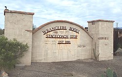 Front gate of the historic Wranglers Roost Stagecoach Stop
 The Station
 The Jack Ass Acres Service Station, which has since been demolished and replaced by a nearby Shell station