Arizona State Land Department

Last updated
Arizona State Land Department
Department overview
Formed20 May 1912;111 years ago (1912-05-20)
(as Arizona State Land Commission)
Jurisdiction Arizona public lands
Department executive
Website azland.gov

The Arizona State Land Department is a department of the state government in the U.S. state of Arizona dedicated to the management of state-owned lands and property.

Contents

Mission statement

The mission statement of the Arizona State Land Department is to manage state trust lands and resources to enhance value and optimize economic return for the trust beneficiaries, consistent with sound stewardship, conservation, and business management principles supporting socioeconomic goals for citizens here today and generations yet to come. The mission is also to manage and provide support for resource conservation programs for the well-being of the public and the state's natural environment. The State Land Department is managed by the State Land Commissioner who is appointed by the Governor. [1]

History

Land Grant & Designation of Beneficiaries

The Territory of Arizona was established on February 24, 1863, by an Act of Congress. This Act granted sections 16 and 36 of each township for the benefit of the Common Schools. Endowment of public lands for educational purposes was a practice established by the Northwest Ordinance in 1787. Congress quickly recognized the value of the land and the importance of public schools to a developing nation. The State Enabling Act, passed on June 20, 1910, allowed the Territory of Arizona to prepare for statehood. In addition to the previously designated sections of land, the Enabling Act assigned sections 2 and 32 of each township to be held in trust for the Common Schools. The needs of other public institutions were considered by Congress, and through the Enabling Act, more than two million additional acres were allocated for their use.

In addition, a 1929 Act authorized an additional 50,000 acres for the Miners’ Hospital Trust. An 1881 Act had already granted the Territory of Arizona about 60,000 acres for the University of Arizona Trust. The total acreage was about 10,900,000. Today, State Trust Land is apportioned among 14 beneficiaries.

Creation of State Land Department

On May 20, 1912, an act of the First Legislature created the three-member State Land Commission to serve as the temporary Land Department of the State. The members were Mulford Winsor, Chairman; Cy Byrne, Secretary; and William A. Moody, member. Appointed by Governor George W. P. Hunt, they were charged with assessing, evaluating, and making recommendations about the land granted by Congress to the State for the Common Schools and other institutions. The commission was to report back to the Legislature with its findings and conclusions by the end of the second Legislative session.

The Commission concluded that Arizona should not sell its Trust land outright, as other states had done. Instead, it should put the lands to their "highest and best use." The decision to sell or lease the land should be based upon the potential use of each parcel. The Commission recommended the creation of a permanent State Land Department "...in order that the multitudinous detail attached to the State’s varied land interests may have constant attention and to prevent irretrievable loss."

The State Land Department and the system by which Trust lands were to be managed were established in 1915 by the State Land Code. In compliance with the Enabling Act and the State Constitution, the State Land Code gave the Department authority over all Trust lands and the natural products from these Trust lands.

Since the State Land Department's inception, its missions have been to manage the Land Trust and to maximize its revenues for the beneficiaries. All uses of the land must benefit the Trust, a fact that distinguishes it from the way public land, such as parks or national forests, may be used. While public use of Trust land is not prohibited, it is regulated to ensure protection of the land and reimbursement to the beneficiaries for its use.

Methods of Land Acquisition

Arizona has acquired lands in four types of transactions.

School Sections in Place
As land surveys were completed by the Federal government, title to four school sections in each township–Sections 2, 16, 32, and 36–automatically passed to the State.
Indemnity in Lieu Selections
When school section lands were not available to the State because they had been previously claimed by homesteaders or miners or because they fell within a Federal reservation or a national forest, park, or Indian reservation, the State was given the right to select an equal acreage of Federal public domain land as indemnity in lieu of the school sections the State should have received.
Quantity Grant Selections
The State selected the specified acreage of Federal lands for the County Bonds and each of the individual institutional Trusts.Land Exchanges
After acquiring title to the Trust lands, the State traded many of the lands for other Federal or private lands of equal value in order to relocate and block up Trust land holdings.
The State acquired its School Sections in Place wherever the land surveys placed them. The State chose the lands acquired in the Indemnity in Lieu Selections, Quantity Grant Selections, and Land Exchange processes.
These choices were made by the State Selection Board, which consists of the Governor, State Attorney General, and State Land Commissioner. The Land Commissioner in recent years has been replaced on the Board by the State Treasurer. Most of the selections were made in the 1915–1960 era, with the selection program being finally completed in 1982. Since the State was precluded by Federal laws from acquiring mineral lands, and since the homesteaders had already acquired most of the potential agricultural lands, the State focused on choosing the best grazing lands.
Most of the acreage chosen during the 1915–1960 era was in central and southeastern Arizona, and in the checkerboard land area along the railroad across north-central Arizona. As agriculture developed in Arizona, later selections were made in irrigated areas in the Harquahala Valley and the Gila River Valley. The final selections concentrated on commercial and agricultural lands along the Colorado River.
Land exchanges in the 1935–1985 era relocated most of the school section lands out of the western deserts and into areas close to Phoenix and Tucson and into better grazing lands in such areas as western Yavapai County.

Location & Uses of State Trust Land

Most of Arizona Trust lands are currently used only for livestock grazing purposes. Several hundred thousand acres of these grazing lands have become urban lands as Phoenix, Tucson, and other cities and towns have expanded. The Urban Lands Act, passed in 1981, enabled the Trust to capitalize on the large increase that planning and zoning adds to raw land values. Today the Land Department's urban lands lease and sale program is the largest revenue producer for the Trust.

Nearly all of the most valuable urban Trust lands around the northern border of the Phoenix metropolitan area and north and west Tucson are Common Schools Trust lands. The large block of Trust lands on the south and southeast sides of the Tucson metropolitan area is divided amongst the various institutional Trusts. The University of Arizona Trust owns a large amount of timbered land acreage in the Flagstaff area and agricultural lands near Yuma. However, the majority of the acreage in the other individual institutional Trusts are rural grazing lands, although some agricultural potential exists.

In the 88 years since statehood, the State has disposed of, or exchanged, about 1,628,079 acres of Trust lands. A total of 9,228,787 acres of Trust Land remains. Almost all of the lands are under one or more leases for natural resource uses and commercial development purposes. About 87 percent of the Trust lands are in the Common School Trust and approximately 90 percent of the Trust revenues go to that Trust. [2]

Issues and reform efforts

Since 1990, there have been 11 measures on the ballot to change how state lands are managed and numerous reform attempts in the legislature. These efforts have produced little real change. Proposed reform measures included making it easier to exchange lands with the federal government, funding the State Land Department from revenues earned, improved protection of natural resources, [3] To improve the revenues from land sales to urban developers, some have recommended that the State Land Department be allowed to issue bonds or enter into partnerships with developers. [4]

In 1998, the Arizona Preserve Initiative fostered the preservation of open space around urban areas through the reclassification of State Trust Land for conservation purposes. [5] The Initiative was later discontinued due to threat of lawsuit. [6]

The State Land Commission has allowed a Saudi company, Fondomonte, to pump unlimited groundwater from its land in the Butler Valley at no charge. [7] Butler Valley was set aside for future ground water delivery to urban areas via the Central Arizona Project canal. The Fondomonte lease has been criticized as substantially below-market. [8]

Arizona State Land Commissioners

Related Research Articles

The Alaska Native Claims Settlement Act (ANCSA) was signed into law by President Richard Nixon on December 18, 1971, constituting at the time the largest land claims settlement in United States history. ANCSA was intended to resolve long-standing issues surrounding aboriginal land claims in Alaska, as well as to stimulate economic development throughout Alaska.

<span class="mw-page-title-main">Bureau of Land Management</span> Agency within the US Department of the Interior

The Bureau of Land Management (BLM) is an agency within the United States Department of the Interior responsible for administering U.S. federal lands. Headquartered in Washington, D.C., the BLM oversees more than 247.3 million acres (1,001,000 km2) of land, or one-eighth of the United States's total landmass.

<span class="mw-page-title-main">National Wildlife Refuge</span> United States protected area designation

National Wildlife RefugeSystem (NWRS) is a system of protected areas of the United States managed by the United States Fish and Wildlife Service (FWS), an agency within the Department of the Interior. The National Wildlife Refuge System is the system of public lands and waters set aside to conserve America's fish, wildlife, and plants. Since President Theodore Roosevelt designated Florida's Pelican Island National Wildlife Refuge as the first wildlife refuge in 1903, the system has grown to over 568 national wildlife refuges and 38 wetland management districts encompassing about 856,000,000 acres (3,464,109 km2).

In all modern states, a portion of land is held by central or local governments. This is called public land, state land, or Crown land. The system of tenure of public land, and the terminology used, varies between countries. The following examples illustrate some of the range.

A land grant is a gift of real estate—land or its use privileges—made by a government or other authority as an incentive, means of enabling works, or as a reward for services to an individual, especially in return for military service. Grants of land are also awarded to individuals and companies as incentives to develop unused land in relatively unpopulated countries; the process of awarding land grants are not limited to the countries named below. The United States historically gave out numerous land grants as Homesteads to individuals desiring to prove a farm. The American Industrial Revolution was guided by many supportive acts of legislatures promoting commerce or transportation infrastructure development by private companies, such as the Cumberland Road turnpike, the Lehigh Canal, the Schuylkill Canal and the many railroads that tied the young United States together.

<span class="mw-page-title-main">Buckeye, Colorado</span> Unincorporated community in Colorado, U.S.

Buckeye is a farming and ranching unincorporated community in north central Larimer County, Colorado, United States. Bounded on the west by the 16,500-acre (67 km2) Roberts Ranch, the area includes Red Mountain Open Space to the north, Rawhide flats to the east, and extends south to Owl Canyon.

<span class="mw-page-title-main">Sagebrush Rebellion</span> Political movement for local control of U.S. government land

The Sagebrush Rebellion was a movement in the Western United States in the 1970s and the 1980s that sought major changes to federal land control, use, and disposal policy in 13 western states in which federal land holdings include between 20% and 85% of a state's area. Supporters of the movement wanted more state and local control over the lands, if not outright transfer of them to state and local authorities and/or privatization. As much of the land in question is sagebrush steppe, supporters adopted the name "Sagebrush Rebellion."

<span class="mw-page-title-main">Federal lands</span> Land in the United States which is owned by the federal government

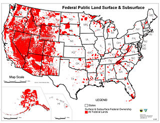
Federal lands are publicly owned lands in the United States managed by the federal government. Pursuant to the Property Clause of the United States Constitution, Congress has the power to retain, buy, sell, and regulate federal lands, such as by limiting cattle grazing on them. These powers have been recognized in a long series of United States Supreme Court decisions.

A Hawaiian home land is an area held in trust for Native Hawaiians by the state of Hawaii under the Hawaiian Homes Commission Act of 1920.

<span class="mw-page-title-main">Wilderness Act</span> American federal law

The Wilderness Act of 1964 was written by Howard Zahniser of The Wilderness Society. It created the legal definition of wilderness in the United States, and protected 9.1 million acres (37,000 km²) of federal land. The result of a long effort to protect federal wilderness and to create a formal mechanism for designating wilderness, the Wilderness Act was signed into law by President Lyndon B. Johnson on September 3, 1964 after over sixty drafts and eight years of work.

<span class="mw-page-title-main">Oneida Indian Nation</span> Indigenous tribe of North America

The Oneida Indian Nation (OIN) or Oneida Nation is a federally recognized tribe of Oneida people in the United States. The tribe is headquartered in Verona, New York, where the tribe originated and held territory prior to European colonialism, and continues to hold territory today. They are Iroquoian-speaking people, and one of the Five Nations of the Iroquois Confederacy, or Haudenosaunee. The Oneida are known as "America's first allies" as they were the first, and one of the few, Iroquois nations to support the American cause. Three other federally recognized Oneida tribes operate in locations where they migrated or were removed to during and after the American Revolutionary War: one in Wisconsin in the United States, and two in Ontario, Canada.

<span class="mw-page-title-main">National Wilderness Preservation System</span> Protection of wilderness areas in the U.S.

The National Wilderness Preservation System (NWPS) of the United States protects federally managed wilderness areas designated for preservation in their natural condition. Activity on formally designated wilderness areas is coordinated by the National Wilderness Preservation System. Wilderness areas are managed by four federal land management agencies: the National Park Service, the U.S. Forest Service, the U.S. Fish and Wildlife Service, and the Bureau of Land Management.

<span class="mw-page-title-main">Kinkaid Act</span>

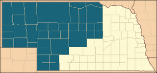
The Kinkaid Act of 1904 is a U.S. statute that amended the 1862 Homestead Act so that one section of public domain land could be acquired free of charge, apart from a modest filing fee. It applied specifically to 37 counties in northwest Nebraska, in the general area of the Nebraska Sandhills. The act was introduced by Moses Kinkaid, Nebraska's 6th congressional district representative, was signed into law by President Theodore Roosevelt on April 28, 1904 and went into effect on June 28 of that year.

<span class="mw-page-title-main">Pascua Yaqui Tribe</span> Yaqui Native American tribe in Arizona

The Pascua Yaqui Tribe of Arizona is a federally recognized tribe of Yaqui Native Americans in the state of Arizona.

In 1898, the United States Congress annexed Hawaiʻi based on a Joint Resolution of Annexation. Questions about the legitimacy of the U.S. acquiring Hawaii through a joint resolution, rather than a treaty, were actively debated in Congress in 1898, and is the subject of ongoing debate. Upon annexation, the Republic of Hawai‘i transferred approximately 1.8 million acres of Hawaiian Government and Crown Lands to the United States (U.S.), which are today held by the State of Hawaiʻi. In the 1993 Apology Resolution, the U.S. government officially apologized to the Native Hawaiian people, acknowledging that the Republic of Hawaiʻi transferred these lands "without the consent of or any compensation to the Native Hawaiian people of Hawaiʻi or their sovereign government" and that "the indigenous Hawaiian people never directly relinquished their claims. .. over their national lands to the United States." Although the lands are commonly referred to as "ceded lands" or "public lands," some refer to them as "seized lands" or "Hawaiian national lands" to highlight the illegal nature of the land transfer, acknowledge different interpretations of the legal effect of the Joint Resolution, and to recognize that Native Hawaiians maintain claims to these lands. Many Native Hawaiian individuals and organizations insist on the return of title, which would be consistent with international law and recognition of the rights of Indigenous peoples, whereas others seek back rent for the use of the land.

<span class="mw-page-title-main">Sun Pass State Forest</span> State Forest in Klamath County, Oregon, United States

Sun Pass State Forest is one of six state forests managed by the Oregon Department of Forestry. The forest is located 40 miles (64 km) north of Klamath Falls, Oregon near the southeastern corner of Crater Lake National Park. It is the largest single block of Oregon state forestry land east of the Cascade Mountains. The forest is managed as part of the Klamath-Lake District, comprising 21,317 acres (86.27 km2) of the 33,739 state-owned acres within the district.

The Board of Commissioners of Public Lands, otherwise known as BCPL, is a state agency responsible for investing Wisconsin's school trust funds in support of public education, for managing the state's remaining school trust lands, and for maintaining an extensive archive of land records. The board was established by Article X, Sections 7 and 8 of the Wisconsin Constitution, ratified in 1848, making it Wisconsin's oldest extant state agency.

State trust lands were granted by the United States Congress to states upon entering the Union. These lands were designated to support essential public institutions which are primarily public schools. State trust land managers lease and sell these lands to generate revenue for current and future designated beneficiaries. Predominantly found in the western United States, 46 million acres of land are currently designated as trust lands and the proceeds from the lease and sale of these lands are distributed into a state's permanent fund and used for many purposes.

<span class="mw-page-title-main">Utah Transfer of Public Lands Act</span>

The State of Utah passed legislation in 2012—the Utah Transfer of Public Lands Act—to require the Federal government to grant the majority of federal land in the state to the state of Utah after 2014. According to Donald J. Kochan, the federal government promised to transfer these lands to the State in the Utah Enabling Act of 1894.

<span class="mw-page-title-main">Sabinoso Wilderness</span>

The Sabinoso Wilderness is a 29,855 acres (120.82 km2) area in San Miguel County, New Mexico. The US Bureau of Land Management owns and administers the wilderness area. The semi-arid wilderness includes few natural resources but has a diverse geology, as well as a range of plant and animal species.

References

  1. "Archived copy" (PDF). Archived from the original (PDF) on 2007-04-18. Retrieved 2007-01-09.{{cite web}}: CS1 maint: archived copy as title (link)
  2. "ASLD History". Archived from the original on 2013-03-21. Retrieved 2013-02-27.
  3. Sonoran Institute, Dan Hunting (2011). "The Quarrel between Past and Present: The Economics of Reforming Arizona's Century Old State Trust Land Rules" (PDF). Retrieved 4 August 2023.
  4. Susan Culp, Dan Hunting (May 2012). "Experimenting with Land Value Capture on Western Public Land". Lincoln Institute of Land Policy. Retrieved 4 August 2023.
  5. The Trust for Public Land (2017). "Arizona Conservation Programs" . Retrieved 4 August 2023.
  6. Coalition for Sonoran Desert Protection (2011). "Arizona State Trust Reform" . Retrieved 4 August 2023.
  7. Lane, Bruce Babbitt and Robert. "Saudi firm has pumped Arizona groundwater for years without paying. Time to pony up". The Arizona Republic. Retrieved 2022-11-03.
  8. Phillips, Nick (26 April 2023). "Fondomonte well rejection will have little impact". Arizona Capitol Times. Retrieved 4 August 2023.
  9. "Why Vanessa Hickman resigned as state land director - Phoenix Business Journal". Archived from the original on 2015-01-20.
  10. "Governor Doug Ducey Appoints State Land Commissioner". 22 April 2015.
  11. KTAR.COM (2023-01-25). "Arizona Gov. Hobbs names directors of regulation, gaming and state land". KTAR.com. Retrieved 2023-04-19.