Maricopa County is in the south-central part of the U.S. state of Arizona. As of the 2020 census the population was 4,420,568, or about 62% of the state's total, making it the fourth-most populous county in the United States, the most populous county in Arizona, and making Arizona one of the nation's most centralized states. The county seat is Phoenix, the state capital and fifth-most populous city in the United States.

Queen Creek is a town just east of Chandler, in Arizona. The population was 59,519 as of the 2020 census, up from 26,361 at the 2010 census. It is a suburb of Phoenix, Arizona located in the far southeast area of the Phoenix metropolitan area. In 2023, a large battery factory was scheduled for 2025.
Nassau Bay is a city in Harris County, Texas, United States, bordering the outermost southeastern edge of the city of Houston. It is located in the Clear Lake Area near Galveston Bay, directly adjacent to the Lyndon B. Johnson Space Center. The population was 5,347 at the 2020 census.

Spring is a census-designated place (CDP) within the extraterritorial jurisdiction of Houston in Harris County, Texas, United States, part of the Houston–The Woodlands–Sugar Land metropolitan area. The population was 62,559 at the 2020 census. While the name "Spring" is popularly applied to a large area of northern Harris County and a smaller area of southern Montgomery County, the original town of Spring, now known as Old Town Spring, is located at the intersection of Spring-Cypress and Hardy roads and encompasses a relatively small area of perhaps 1 square kilometer (0.39 sq mi).

Webster is a city in the U.S. state of Texas located in Harris County, within the Houston–The Woodlands–Sugar Land metropolitan area. Its population was 12,499 at the 2020 U.S. census.

Playa del Rey is a seaside community in the Santa Monica Bay and the Westside region of Los Angeles, California. It has a ZIP code of 90293 and area codes of 310 and 424. As of 2018, the community had a population of 16,230 people.

Klein is an unincorporated community in Harris County, Texas, United States, roughly bordering Texas State Highway 99 to the north, Texas State Highway 249 to the west, Interstate 45 to the east, and the city of Houston to the south. It includes the entire area of Klein ISD. Residents of the zip codes 77066, 77069, 77086, 77379, 77388, 77389 and 77391 can use Klein as their postal city. Klein is one of the most diverse, as well as being one of the largest unincorporated areas of Houston.

This is a list of the National Register of Historic Places listings in Maricopa County, Arizona, excluding those in Phoenix, for which see this separate list.
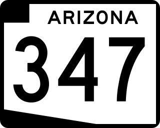
State Route 347, also known as John Wayne Parkway, is a 28.69 miles (46.17 km) long, north–south state highway in central Arizona. The route begins at SR 84 and heads north. It passes through Maricopa, meeting SR 238. The route ends at an interchange with Interstate 10 (I-10) south of Chandler. It primarily serves as the major road to Maricopa; much of the road lies within the Gila River Indian Community, with another short stretch through the Ak-Chin Indian Community. The road was built in the late 1930s and established as a state highway in the 1990s. On average, between 4,000 and 35,000 vehicles use the roadway daily.
Falcon is an unincorporated community exurb in El Paso County, Colorado, United States. It lies along US 24 about 14 miles northeast of Colorado Springs. A railroad hub in the early 20th century, the town spent several decades as a quiet ranching community until it experienced rapid residential growth throughout the 1990s which has continued increasingly through today. The population of Falcon as of 2009 was estimated to be 10,514. The U.S. Post Office in Peyton, Colorado serves Falcon postal addresses.

The Higley Unified School District #60, abbreviated HUSD #60 is a school district in Gilbert, Arizona. The school district serves portions of Gilbert and Queen Creek. It is one of Arizona's fastest growing school districts, with modest continued growth despite the downturn in the economy at the end of the 2000s (decade). The District owns two preschools, nine elementary schools, two middle schools, two high schools, and one virtual academy. In August 2013, the district opened two new middle schools and all other elementary schools that hosted grades K-8 went down to K-6.

Havilah is an unincorporated community in Kern County, California. It is located in the mountains between Walker Basin and the Kern River Valley, 5 miles (8.0 km) south-southwest of Bodfish at an elevation of 3,136 feet (956 m).

Williams Field High School (WFHS) is a high school in Gilbert, Arizona. It is the second high school formed by the Higley Unified School District, and opened in August 2007. Its first students graduated in 2010. The school is named after Williams Air Force Base. The school is located near Higley Elementary and the Lyons Gate community.
Pottsville is an unincorporated community located in western Hamilton County in Central Texas.
El Jardin del Mar is a community located in Pasadena, Texas, United States. Places within El Jardin have Seabrook, Texas postal addresses. Most of El Jardin's residents are those of the working class.
Queen Creek Unified School District (QCUSD) is a school district based in Queen Creek, Arizona, United States. It was formed in 1947 from land once part of the Higley Unified School District (at the time, neither district was unified; Queen Creek High School would not open until 1967).
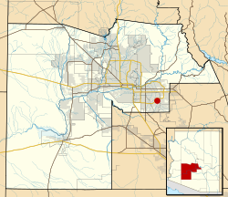
San Tan Valley is an unincorporated community and census-designated place in northern Pinal County, Arizona, United States. With 99,894 residents as of the 2020 census, San Tan Valley is the largest unincorporated municipality in Pinal County.

Bapchule is an unincorporated community just west of South Chandler, in Pinal and Maricopa counties, Arizona, United States. It lies in the Gila River Indian Community, south of the Phoenix Metropolitan Area. Most of Bapchule is located in Pinal County, while a portion of it in the north is in Maricopa County. Its elevation is 1,197 feet (365 m), and it is located at 33°08′11″N111°52′23″W. Although Bapchule is unincorporated, it has a post office with the ZIP code of 85121.
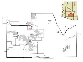
Chandler Heights was a census-designated place and is an unincorporated community in Maricopa and Pinal counties, Arizona, United States. It is 11 miles southeast of Chandler. Formerly, Chandler Heights had a ZIP code of 85227, but it has since been abolished, and the United States Postal Service now uses "Queen Creek" for all Chandler Heights addresses.