
Maricopa County is in the south-central part of the U.S. state of Arizona. As of the 2020 census, the population was 4,420,568, making it the state's most populous county, and the fourth-most populous in the United States. It contains about 62% of Arizona's population, making Arizona one of the most centralized states in the nation. The county seat is Phoenix, the state capital and fifth-most populous city in the United States.

Gilbert is a town in Maricopa County, Arizona, United States, located southeast of Phoenix within the city's metropolitan area. Incorporated on July 6, 1920, Gilbert was once known as the "Hay Shipping Capital of the World". It is the fifth-largest municipality in Arizona, and the fourth-largest in the Phoenix metro area. It covers an area of nearly 69 square miles (179 km2).

Maricopa is a city in the Gila River Valley in Pinal County, Arizona, United States. With 62,720 residents as of 2021, Maricopa is the largest incorporated municipality in Pinal County
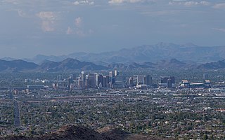
The Phoenix Metropolitan Area – also the Valley of the Sun, the Salt River Valley, or Metro Phoenix – is the largest metropolitan area in the Southwestern United States, centered on the city of Phoenix, that includes much of the central part of Arizona. The United States Office of Management and Budget designates the area as the Phoenix-Mesa-Chandler Metropolitan Statistical Area (MSA), defining it as Maricopa and Pinal counties. As of the 2020 census, Metro Phoenix had 4,845,832 residents, making it the 11th largest metropolitan area in the nation by population. It anchors the Arizona Sun Corridor megaregion along with the second most populous metropolitan area in the state, the Tucson metropolitan area. The gross domestic product of the Phoenix Metropolitan Area was $255 billion in 2018, 16th largest amongst metro areas in the United States.

This is a list of the National Register of Historic Places listings in Maricopa County, Arizona, excluding those in Phoenix, for which see this separate list.
Allenville was a community located in western Maricopa County, Arizona, United States, south of the town of Buckeye, on the edge of the Gila River, at an estimated elevation of 837 feet (255 m) above sea level.
Apache Wells is the name of both fictional and real locations in southern Arizona.
Arrowhead Ranch is a populated place situated in the city of Glendale in Maricopa County, Arizona, United States. It has an estimated elevation of 1,270 feet (390 m) above sea level. Arrowhead Ranch is a former citrus farm. It was purchased for development in 1978 and annexed by Glendale in 1979.

Weedville is a populated place situated within the city limits of Peoria in Maricopa County, Arizona, United States. It was a small community founded in 1911, in an area which, at the time, was outside the city limits of Peoria. The area is located within the pockets of unincorporated land under the jurisdiction of Maricopa County. All of the census and demographic data for the residents of Weedville are part of the information reported for the city of Peoria, since Weedville is located within the limits of that city.
Co-op Village is a populated place situated in Maricopa County, Arizona, United States. It is located in the Gila River Indian Community. It has an estimated elevation of 1,007 feet (307 m) above sea level.
Forepaugh is a populated place situated in Maricopa County, Arizona, United States. It has an estimated elevation of 2,303 feet (702 m) above sea level. It is located along the Arizona and California Railroad.
Heaton is a populated place situated in Pinal County, Arizona, United States. Originally called Maricopa Station, it served as a stop on the railroad line, where passengers transferred to stagecoach. The post office at this location was simply named Maricopa. During a land boom in the late 1880s, it was thought that this stop would become a railway stop on the line directly connecting to Phoenix. As expansion into a town was being considered if the planned rail connection became reality, the expanded community was to be named Maricopaville. In 1887, when the rail line connection went to Maricopa Junction instead, the town's expansion was abandoned, and the name of the town was changed to its current Heaton. It has an estimated elevation of 1,197 feet (365 m) above sea level.
Horse Mesa is a populated place situated along the border with New Mexico in Apache County, Arizona, United States. It is one of two populated places in the state with this name, the other being situated in Maricopa County. It has an estimated elevation of 5,653 feet (1,723 m) above sea level.
Lizard Acres was a former cattle ranch, subdivision, and train stop situated in Maricopa County, Arizona, near the present day town of Surprise. It has an estimated elevation of 1,191 feet (363 m) above sea level.
Maricopa Village is a populated place situated in Maricopa County, Arizona, United States. It has an estimated elevation of 978 feet (298 m) above sea level.
Matthie is a populated place situated in Maricopa County, Arizona, United States. It has an estimated elevation of 2,320 feet (710 m) above sea level.

Sacate is a populated place in the Middle Gila River Valley area, within Pinal County, Arizona, United States. Located eight miles north of Maricopa on the south side of the Gila River near Pima Butte, Sacate was an Pima village, a railroad station of the Southern Pacific Railroad, and a Catholic mission. It had originally been called Sacaton Station but the name was shortened to its current version in 1904.

Salt River is a populated place situated in Maricopa County, Arizona, United States. It has an estimated elevation of 1,220 feet (370 m) above sea level. It is located on the Salt River Pima–Maricopa Indian Community.
San Lucy Village is a populated place situated in Maricopa County, Arizona, United States. It has an estimated elevation of 702 feet (214 m) above sea level. It is located one mile north of Gila Bend. and has approximately 300 residents, almost all Tohono O'odham. San Lucy Village was previously located elsewhere but was moved due to the construction of the Painted Rock Dam.
Santa Maria is a populated place situated in Maricopa County, Arizona, United States. It has an estimated elevation of 1,020 feet (310 m) above sea level. Originally a rural settlement, Santa Maria is now surrounded by Estrella, Phoenix.


