Vulture City, Arizona

Last updated

Vulture City, Arizona
Wickenburg Vulture Mine-Assay office-1884-1.jpg
Vulture Mine-Assay office, built in 1884
USA Arizona location map.svg
Red pog.svg
Vulture
Usa edcp location map.svg
Red pog.svg
Vulture
Coordinates: 33°49′02″N112°49′59″W / 33.81722°N 112.83306°W / 33.81722; -112.83306
CountryUnited States
State Arizona
County Maricopa

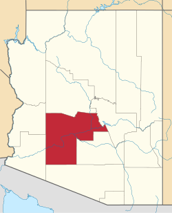
Vulture City is a ghost town situated at the site of the defunct Vulture Mine in Maricopa County, Arizona, United States.

Contents

Vulture Mine

Vulture Mine was a gold mine which was discovered in 1863. It was the most productive gold mine in the history of Arizona. From 1863 to 1942, the mine produced 340,000 ounces (9,638.8 kgs) of gold and 260,000 ounces (7,370.9 kgs) of silver. [1] [2] The mine was discovered when Henry Wickenburg, a prospector from California's gold rush, stumbled upon a quartz deposit containing gold while traveling in Arizona. Wickenburg began mining the outcrop himself.

In 1863, after Henry Wickenburg discovered the mine, Vulture City, a small mining town, was established in the area. Vulture City's post office was established on October 4, 1880, and Henry Wickenburg was the town's first postmaster. The town had more than five boarding houses and several buildings. The huge Vulture Mine-Assay Office building, built in 1884, still stands today. The town also had a cookhouse and mess hall plus stores, saloons and even a school. [3] The town once had a population of 5,000 citizens. It was marked by violence. Eighteen men were hanged on an ironwood tree located by the ruins of Henry Wickenburg's house. [4]

Abandonment

After the mine closed, the city was abandoned and its buildings decayed, becoming a ghost town. The deposit was later sold to Benjamin Phelps, who represented a group of investors that eventually organized under the name of Vulture Mining Company. The mine continued to produce at a decreased level until World War II, when it was permanently closed. More recently, the owner has offered a two-hour, dirt path guided walking tour of the mine. [1] [2] [3] [4]

The following is a list, which includes a photographic gallery, of some of the remaining structures of historic significance in what once was known as Vulture City. Some of these structures are just mere ruins while others are still standing in fairly good condition. Also included in the gallery are some images of the Vulture Mine. [1] [2] [3] [4]

Images of Vulture City and Mine
NameImageNameImage
1Vulture City main gate house Wickenburg Vulture Mine-Gate House.jpg 2Houses Wickenburg Vulture Mine-Ghost town houses.jpg
3Dynamite House where dynamite and ammo was stored. Wickenburg Vulture Mine -Ammo House.jpg 4Gas station Wickenburg Vulture Mine-Gas Station.jpg
5Workshop Wickenburg Vulture Mine-Workshop.jpg 6The Vulture_Mine-Assay office. Wickenburg Vulture Mine-Assay House-2.jpg
7Side view of the Vulture Mine-Assay office Wickenburg Vulture Mine-Assay office-1884-3.jpg 8Vulture City Chow House where the miners ate. Wickenburg Vulture Mine-Chow House.jpg
9The Vulture City Chow House kitchen. Wickenburg Vulture Mine-Inside Chow House.jpg 10 Hanging Tree. Wickenburg Vulture Mine-Hanging Tree.jpg
11The ruins of Henry Wickenburg's Settlers Home in Vulture City. Wickenburg Vulture Mine-Wickenburg's Settler home-2.jpg 12One of the Miners Living Quarters Wickenburg Vulture Mine-Miners living quarters.jpg
13Rita's Brothel Wickenburg Vulture Mine-Rita's Brothel.jpg 14The ruins of the Vulture City Saloon Wickenburg Vulture Mine-Saloon ruins.jpg
15The ruins of the Vulture City Post Office which opened in 1880 and whose postmaster was Henry Wickenburg Wickenburg Vulture Mine-Post Office-1880 ruins.jpg 16Original equipment used in the Vulture Mine Wickenburg Vulture Mine-Mine equipment.jpg
17Vulture Mine and Vulture Mountain and caves. Wickenbug Vulture Mine-Vulture Mounatin and caves.jpg 18Nickel Shaft Wickenbug Vulture Mine-Nickel Shaft.jpg
19Entrance to the Vulture Mine gold mine shaft. Wickenbug Vulture Mine-Entrance to Vulture Mine Shaft.jpg 20Inside of the entrance of the gold mine shaft. Wickenburg Vulture Mine-Vulture Mine Shaft.jpg
21The Texas Hotel was built in 1895 in Vulture City. In 1904, the hotel was moved to Wickenburg. The hotel had a restaurant on the street floor and eight rental units upstairs. Wickenburg-Texas Hotel-1895.jpg

Further reading

See also

Related Research Articles

<span class="mw-page-title-main">Congress, Arizona</span> CDP in Yavapai County, Arizona

Congress is a census-designated place (CDP) in Yavapai County, Arizona, United States. Once a gold-mining center for the Congress Mine and then a ghost town, Congress now serves as a retirement and bedroom community for nearby Wickenburg. The population was 1,811 at the 2020 census.

<span class="mw-page-title-main">Dewey–Humboldt, Arizona</span> Town in Yavapai County, Arizona

Dewey–Humboldt is a town in Yavapai County, Arizona, United States. The population of the town was 3,894 according to the 2010 census. The Dewey–Humboldt area was a census-designated place (CDP) at the 2000 census, at which time its population was 6,295.

<span class="mw-page-title-main">Calico, California</span> Place in California, United States

Calico is a ghost town and former mining town in San Bernardino County, California, United States. Located in the Calico Mountains of the Mojave Desert region of Southern California, it was founded in 1881 as a silver mining town, and was later converted into a county park named Calico Ghost Town. Located off Interstate 15, it lies 3 miles (4.8 km) from Barstow and 3 miles from Yermo. Giant letters spelling CALICO are visible, from the highway, on the Calico Peaks behind it. Walter Knott purchased Calico in the 1950s, and rebuilt all but the five remaining original buildings to look as they did in the 1880s. Calico received California Historical Landmark #782, and in 2005 was proclaimed by then-Governor Arnold Schwarzenegger to be California's Silver Rush Ghost Town.

<span class="mw-page-title-main">Oatman, Arizona</span> Census-designated place in Mohave County, Arizona, United States

Oatman is a census-designated place (CDP) in the Black Mountains of Mohave County, Arizona, United States, at an elevation of 2,710 feet (830 m). In 1915, it began as a small mining camp when two prospectors struck US$10 million in gold, though the vicinity had already been settled for several years. Oatman's population grew to more than 3,500 in one year. As of the 2020 United States census, its population was 102.

<span class="mw-page-title-main">Gold mining in the United States</span>

In the United States, gold mining has taken place continually since the discovery of gold at the Reed farm in North Carolina in 1799. The first documented occurrence of gold was in Virginia in 1782. Some minor gold production took place in North Carolina as early as 1793, but created no excitement. The discovery on the Reed farm in 1799 which was identified as gold in 1802 and subsequently mined marked the first commercial production.

<span class="mw-page-title-main">Silver mining in the United States</span>

Silver mining in the United States began on a major scale with the discovery of the Comstock Lode in Nevada in 1858. The industry suffered greatly from the demonetization of silver in 1873 by the Coinage Act of 1873, known pejoratively as the "Crime of 73", but silver mining continues today.

La Paz was a short-lived early gold mining town along on the western border of current-day La Paz County, Arizona. The town grew quickly after gold was discovered nearby in 1862. La Paz, Spanish for peace, was chosen as the name in recognition of the feast day for Our Lady of Peace. Originally located in the New Mexico Territory, the town became part of the Arizona Territory when President Abraham Lincoln established the new territory in 1863. In 1983 the newly-formed County of La Paz adopted the name, long after the town had become a ghost town.

Silver mining in Arizona was a powerful stimulus for exploration and prospecting in early Arizona. Cumulative silver production through 1981 totaled 490 million troy ounces. However, only about 10% of Arizona's silver production came from silver mining. More than 80% of the state's silver was a byproduct of copper mining; other silver came as a byproduct of lead, zinc, and gold mining.

<span class="mw-page-title-main">Vulture Mine</span> Defunct gold mine in Maricopa County, Arizona

The Vulture Mine was a gold mine and settlement in Maricopa County, Arizona, United States. The mine began in 1863 and became the most productive gold mine in Arizona history. From 1863 to 1942 A.D., the mine produced 340,000 ounces of gold and 260,000 ounces of silver. Historically, the mine attracted more than 5,000 people to the area, and is credited with founding the town of Wickenburg, Arizona. The town that served the mine was known as Vulture City.

<span class="mw-page-title-main">Castle Dome Landing, Arizona</span> Ghost town in Yuma County, Arizona

Castle Dome Landing, Arizona is a ghost town in the Castle Dome Mountains of Yuma County in the U.S. state of Arizona. It was first settled as a transport depot and mining camp around 1863 in what was then the Arizona Territory.

<span class="mw-page-title-main">Weaver, Arizona</span> Ghost town in Yavapai County, Arizona

Weaver, or Weaverville, is a former gold mining town, now a deserted ghost town, in Yavapai County, Arizona, United States. All that remains are some rusting mining machinery, a partially restored cemetery, and the ruins of a stone house.

<span class="mw-page-title-main">Alamo Crossing, Arizona</span> Ghost town in Arizona, United States

Alamo Crossing is a ghost town in Mohave County, Arizona, United States. The town was settled in the late 1890s, in what was then the Arizona Territory. It served as a camp for mining prospectors in the manganese-rich Artillery Mountains, being the only town in the area. After 1918, the post office permanently closed, but the town was only intermittently abandoned, with its founders often present through until at least the mid-1950s. The town was intentionally flooded in 1968 to create Alamo Lake. In 2020, the area of Alamo was revived for mining again, this time for surface-level gold prospecting.

Bradshaw City is a ghost town in Yavapai County, Arizona, United States. It served as a mining camp from its founding in 1863 until the late 1880s. "Bradshaw City" is the namesake of its founder, William D. Bradshaw.

Gila City is a ghost town in Yuma County in the U.S. state of Arizona. The town was settled in 1858 in what was then the New Mexico Territory.

<span class="mw-page-title-main">Vulture Mountains</span> Low level mountain range in Arizona

The Vulture Mountains is a 29-mile (47 km) long, arid, low-elevation mountain range located in northwest Maricopa County, Arizona, United States. It is in the north perimeter region of the Sonoran Desert. The Arizona transition zone mountain ranges lie north and northeast, just north of Wickenburg, Arizona. The Yarnell Hill, about 14 miles (23 km) north of Wickenburg, rising into the Weaver Mountains to Yarnell, marks the dramatic elevation rise from the desert. It is also a viewpoint southwest and southeast of the desert regions, including the Vulture Mountains.

<span class="mw-page-title-main">Henry Wickenburg</span> Arizona pioneer and miner (1819–1905)

Henry Wickenburg was a Prussian prospector who discovered the Vulture Mine and founded the town of Wickenburg in the U.S. state of Arizona. Wickenburg never married. Mrs. Helene Holland inherited Wickenburg’s personal property in 1903, while he was still alive, and the remainder of his estate in 1905 after Henry Wickenburg died from a gunshot wound in the head. His death was deemed a suicide, but many questioned this ruling. The mine that he discovered produced as much as $70 million worth of gold during its course of operation, making it the most important gold mine in Arizona.

<span class="mw-page-title-main">Fort Tyson</span> Historic site in La Paz County, Arizona

Fort Tyson was a privately owned fort built in 1856 by Charles Tyson in the area which is now called Quartzsite, Arizona. He built the fort to protect the local miners and water supply from the raids of the Yavapai (Mohave-Apache), a Native-American tribe. The area in which Fort Tyson was located has been known as Fort Tyson, Tyson’s Well and is now called the town of Quartzsite because of the large amount of quartz found in its surrounding areas.

References