
The gunfight at the O.K. Corral pitted lawmen against members of a loosely organized group of cattle rustlers and horse thieves called the Cowboys on October 26, 1881. While lasting less than a minute, the gunfight has been the subject of books and films into the 21st century. Taking place in the town of Tombstone in Arizona Territory, the battle has become one archetype of the American Old West. The gunfight was the result of a long-simmering feud between five outlaws and four representatives of the law, including three brothers. The trigger for the event was the local marshal's decision to enforce a city ordinance that prohibited the carrying of weapons into town. To enforce that ordinance, the lawmen would have to disarm the Cowboys.

Cochise County is a county in the southeastern corner of the U.S. state of Arizona. It is named after Cochise, a Chiricahua Apache who was a key war leader during the Apache Wars.

Sierra Vista is a city in Cochise County, Arizona, United States. According to the 2020 Census, the population of the city is 45,308, and is the 27th most populous city in Arizona. The city is part of the Sierra Vista-Douglas Metropolitan Area, with a 2010 population of 131,346. Fort Huachuca, a U.S. Army post, has been incorporated and is located in the northwest part of the city. Sierra Vista is bordered by the cities of Huachuca City and Whetstone to the north and Sierra Vista Southeast to the South.
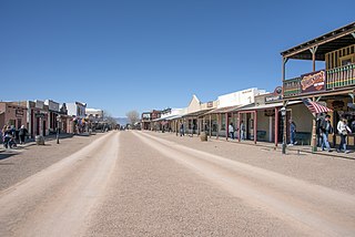
Tombstone is a city in Cochise County, Arizona, United States, founded in 1879 by prospector Ed Schieffelin in what was then Pima County, Arizona Territory. It became one of the last boomtowns in the American frontier. The town grew significantly into the mid-1880s as the local mines produced $40 to $85 million in silver bullion, the largest productive silver district in Arizona. Its population grew from 100 to around 14,000 in less than seven years. It is best known as the site of the Gunfight at the O.K. Corral and draws most of its revenue from tourism. The city had a permanent population of 1,308, according to the 2020 census.

Billy Claiborne was an American outlaw, cowboy, drover, miner, and gunfighter in the American Old West. He killed James Hickey in a confrontation in a saloon, but it was ruled self-defense. He was present at the beginning of the Gunfight at the O.K. Corral, but was unarmed and ran from the shootout. Only a year later, while drunk, he confronted gunfighter "Buckskin" Frank Leslie and was killed.

Joseph Isaac Clanton was a member of a loose association of outlaws known as The Cowboys who clashed with lawmen Wyatt, Virgil and Morgan Earp as well as Doc Holliday. On October 26, 1881, Clanton was present at the gunfight at the O.K. Corral in the boomtown of Tombstone, Arizona Territory, but was unarmed and ran from the gunfight, in which his 19-year-old brother Billy was killed.

John Harris Behan was an American law enforcement officer and politician who served as Sheriff of Cochise County in the Arizona Territory, during the gunfight at the O.K. Corral and was known for his opposition to the Earps. Behan was sheriff of Yavapai County from 1871 to 1873. He was married and had two children, but his wife divorced him, accusing him of consorting with prostitutes. He was elected to the Seventh Arizona Legislative Assembly, representing Yavapai County. In 1881, Wyatt Earp served for about five months as undersheriff of the eastern half of Pima County. When Wyatt resigned, Behan was appointed to fill his place, which included the mining boomtown Tombstone. When Cochise County was formed in February 1881, Behan was appointed as its first sheriff. Tombstone became the new county seat and the location of Behan's office. Sadie Marcus was his mistress, possibly as early as 1875 in Tip Top, Arizona, and certainly from 1880 until she found him in bed with another woman and kicked him out in mid-1881.

Newman Haynes Clanton, also known as "Old Man" Clanton, was a cattle rancher and father of four sons, one of whom was killed during the Gunfight at the O.K. Corral. Two of his sons were involved in multiple conflicts in Cochise County, Arizona Territory including stagecoach robbery and cattle rustling. One witness identified his son Ike Clanton as a participant in the murder of Morgan Earp. Billy Clanton and Ike were at the O.K. Corral. "Old Man" Clanton was reportedly involved with stealing cattle from Mexican ranchers and re-selling them in the United States. Records indicate he participated in the Skeleton Canyon Massacre of Mexican smugglers. In retaliation, Mexican Rurales are reported to have ambushed and killed him and a crew of Cowboys in the Guadalupe Canyon Massacre.
The Guadalupe Canyon Massacre was an incident that occurred on August 13, 1881, in the Guadalupe Canyon area of the southern Peloncillo Mountains – Guadalupe Mountains. Five American men were killed in an ambush, including "Old Man" Clanton, the alleged leader. They most likely belonged to The Cowboys, an outlaw group based in Pima and Cochise counties in Arizona. Two men survived the attack. The canyon straddles the modern Arizona and New Mexico state line and connects the Animas Valley of New Mexico with the San Bernardino Valley of Arizona. During the American Old West, the canyon was a key route for smugglers into and out of Mexico.

Charleston is a ghost town in Cochise County in the southeastern part of the U.S. state of Arizona. It was occupied from the late-1870s through the late-1880s, and was located in what was then known as the Arizona Territory. Located on the west bank of the San Pedro River, Charleston's economy was based on milling silver ore mined from nearby Tombstone in the community of Millville, located directly across the river.

Frank McLaury born Robert Findley McLaury was an American outlaw. He and his brother Tom allegedly owned a ranch outside Tombstone, Arizona, although this ownership is disputed, that cowboy Frank Patterson owned the ranch. Arizona Territory during the 1880s, and had ongoing conflicts with lawmen Wyatt, Virgil, and Morgan Earp. The McLaury brothers repeatedly threatened the Earps because they interfered with the Cowboys' illegal activities. On October 26, 1881, Tom, Frank, and Billy Clanton were killed in the Gunfight at the O.K. Corral.

Tom McLaury was an American outlaw. He and his brother Frank owned a ranch outside Tombstone, Arizona, Arizona Territory during the 1880s. He was a member of a gang of outlaws and cattle rustlers called the Cowboys that had ongoing conflicts with lawmen Wyatt, Virgil, and Morgan Earp. The McLaury brothers repeatedly threatened the Earps because they interfered with the Cowboys' illegal activities. On October 26, 1881, Tom and Frank were both killed in the Gunfight at the O.K. Corral in Tombstone, Arizona Territory. The Tombstone shootout was his only gunfight.

William Harrison Clanton was an outlaw Cowboy in Cochise County, Arizona Territory. He, along with his father Newman Clanton and brother Ike Clanton, worked a ranch near the boomtown of Tombstone, Arizona Territory and stole livestock from Mexico and later U.S. ranchers.

Camillus "Buck" Sydney Fly was an Old West photographer who is regarded by some as an early photojournalist and who captured the only known images of Native Americans while they were still at war with the United States. He took many other pictures of life in the silver-mining boom town of Tombstone, Arizona, and the surrounding region. He recognized the value of his photographs to illustrate periodicals of the day and took his camera to the scenes of important events where he recorded them and resold pictures to editors nationwide.
The Cochise County Cowboys is the modern name for a loosely associated group of outlaws living in Pima and Cochise County, Arizona in the late 19th century. The term "cowboy", as opposed to "cowhand," had only begun to come into wider usage during the 1870s. In that place and time, "cowboy" was synonymous with "cattle rustler". Such thieves frequently rode across the border into Mexico and stole cattle from Mexican ranches that they then drove back across the border to sell in the United States. Some modern writers consider them to be an early form of organized crime in America.

Cochise County in southeastern Arizona was the scene of a number of violent conflicts in the 19th-century and early 20th-century American Old West, including between white settlers and Apache Indians, between opposing political and economic factions, and between outlaw gangs and local law enforcement. Cochise County was carved off in 1881 from the easternmost portion of Pima County during a formative period in the American Southwest. The era was characterized by rapidly growing boomtowns, the emergence of large-scale farming and ranching interests, lucrative mining operations, and the development of new technologies in railroading and telecommunications. Complicating the situation was staunch resistance to white settlement from local Native American groups, most notably during the Apache Wars, as well as Cochise County's location on the border with Mexico, which not only threatened international conflict but also presented opportunities for criminal smugglers and cattle rustlers.
Phineas Fay Clanton was the son of Newman Haynes Clanton and the brother of Billy and Ike Clanton. He was witness to and possibly played a part in a number of illegal activities during his life. He moved frequently in his early life from Missouri to California and to Arizona.

The Little Boquillas Ranch is an historic ranch property located in western Cochise County, Arizona, near the Fairbank Historic Townsite in what is now part of the San Pedro Riparian National Conservation Area.
Lewis Springs, also called San Pedro Springs after the nearby San Pedro River, is a populated place situated in Cochise County, Arizona, United States.


