
Cochise County is a county in the southeastern corner of the U.S. state of Arizona. It is named after the Native American chief Cochise.

Heber-Overgaard is a census-designated place (CDP) in Navajo County, Arizona, United States. Situated atop the Mogollon Rim, the community lies at an elevation of 6,627 feet (2,020 m). The population was 2,898 at the 2020 census. Heber and Overgaard are technically two unincorporated communities, but as of the 1990 census, their proximity led to the merged name of "Heber-Overgaard".

Patagonia is a town in Santa Cruz County, Arizona, United States. As of the 2010 census it had a population of 913. It developed in the mid-19th century as a trading and supply center for nearby mines and ranches. In the 21st century, it is a tourist destination, retirement community, and arts and crafts center.
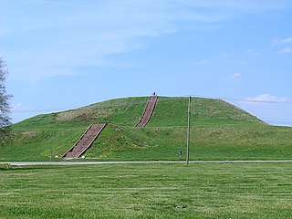
The Cahokia Mounds State Historic Site is the site of a pre-Columbian Native American city directly across the Mississippi River from modern St. Louis, Missouri. This historic park lies in south-western Illinois between East St. Louis and Collinsville. The park covers 2,200 acres (890 ha), or about 3.5 square miles (9 km2), and contains about 80 manmade mounds, but the ancient city was much larger. At its apex around 1100 CE, the city covered about 6 square miles (16 km2) and included about 120 earthworks in a wide range of sizes, shapes, and functions.

The Gadsden flag is a historical American flag with a yellow field depicting a timber rattlesnake coiled and ready to strike. Beneath the rattlesnake are the words: "DONT TREAD ON ME". Some modern versions of the flag include an apostrophe.

Kristin James Benson is a former Major League Baseball starting pitcher who played for several teams between 1999 and 2010.

Greer is an unincorporated community and census-designated place in Apache County, Arizona, United States. Located within the White Mountains of Arizona and surrounded by the Apache-Sitgreaves National Forest, Greer is the highest town in the state at an elevation of approximately 8,400 feet. As of the 2020 census it had a population of 58. Greer was founded circa 1879 by Mormon settlers from Utah. The Greer post office has the ZIP code of 85927.

Laveen is a community in Maricopa County, Arizona, United States, situated eight miles (13 km) southwest of Downtown Phoenix, between South Mountain and the confluence of the Gila and Salt rivers. Parts of Laveen constitute an unincorporated community in Maricopa County, while the remainder falls within the city limits of Phoenix, constituting the city's "Laveen Village" an urban village within the city of Phoenix. Laveen Village is split between District 7 and District 8, both notable as minority-majority districts for the city. Although Laveen has been home to "pastoral alfalfa, cotton, and dairy farms" since the 1880s, housing and commercial developments have been increasingly urbanizing the area.
Tres Alamos is a ghost town in Cochise County in the U.S. state of Arizona. The town was settled in 1874 in what was then the Arizona Territory.

Contention City or Contention is a ghost mining town in Cochise County in the southeastern part of the U.S. state of Arizona. It was occupied from the early-1880s through the late-1880s in what was then known as the Arizona Territory. Only a few foundations now remain of this boomtown which was settled and abandoned with the rise and fall of silver mining in and around the area of Tombstone.

Homolovi State Park is a state park of Arizona, United States, preserving over 300 Ancestral Puebloan archaeological sites. Homolovi or Homol'ovi is a Hopi word meaning "place of the little hills". The park is located just over a mile north of Winslow, Arizona, and features historical exhibits, interpretive programs, birdwatching, and hiking. There is a year-round campground, restrooms with showers and an RV dump station. The park was closed to visitors from February 22, 2010 to March 18, 2011 due to state budget cuts.

Arizona is a state in the Southwestern United States. It is the 6th-largest and the 14th-most-populous of the 50 states. Its capital and largest city is Phoenix. Arizona is part of the Four Corners region with Utah to the north, Colorado to the northeast, and New Mexico to the east; its other neighboring states are Nevada to the northwest, California to the west and the Mexican states of Sonora and Baja California to the south and southwest.

Concho is an unincorporated community and census-designated place (CDP) in Apache County, Arizona, United States. Concho is located on Arizona State Route 61, 14 miles (23 km) west of St. Johns. Concho was the original site for the state capital, due to its prosperous farming. As of the 2010 census, the Concho CDP had a population of 38.
Weatherby is an unincorporated community in Baker County, Oregon, United States. It is about 9 miles (14 km) southeast of Durkee on Interstate 84/U.S. Route 30, near the Burnt River.

Stanton is a populated place in Yavapai County, Arizona, United States that is now used as an RV park. The town was originally a stagecoach stop known as Antelope Station, and was later renamed "Stanton" after the businessman and crook Chuck Stanton, who took over the town in the 1870s. Stanton is located approximately twenty miles north of Wickenburg, at the base of Rich Hill, near the ghost towns of Octave and Weaver.

Loki is an American television series created by Michael Waldron for the streaming service Disney+, based on Marvel Comics featuring the character of the same name. It is the third television series in the Marvel Cinematic Universe (MCU) produced by Marvel Studios, sharing continuity with the films of the franchise. The series takes place after the events of the film Avengers: Endgame (2019), in which an alternate version of Loki created a new timeline. Waldron served as head writer and Kate Herron directed the first season, with Eric Martin and the duo Justin Benson and Aaron Moorhead serving as head writer and leading the directing team for the second season, respectively.
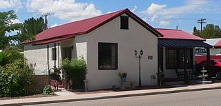
The Benson Historic Barrio is a small neighborhood in Benson, Arizona. It began to develop between 1898 and 1901, settled primarily with people of Mexican descent. It is located on the east side of the original townsite, just south of the business district, and comprises three blocks along both sides of East Fifth Street, encompassing blocks, 19, 20, 21, 23, 24, and 25. It includes houses, lots, other buildings, and Our Lady of Lourdes Catholic Church.


