
Gila Bend, founded in 1872, is a town in Maricopa County, Arizona, United States. The town is named for an approximately 90-degree bend in the Gila River, which is near the community's current location. As of the 2020 census, the population of the town was 1,892.

Litchfield Park is a city in Maricopa County, Arizona, United States. It is located 19 miles (31 km) west of Phoenix. As of the 2020 census, the population of the city was 6,847, up from 5,476 in 2010.

Dewey–Humboldt is a town in Yavapai County, Arizona, United States. The population of the town was 3,894 according to the 2010 census. The Dewey–Humboldt area was a census-designated place (CDP) at the 2000 census, at which time its population was 6,295.

Stanwix Station, in western Arizona, was a stop on the Butterfield Overland Mail Stagecoach line built in the later 1850s near the Gila River about 80 miles (130 km) east of Yuma, Arizona. Originally the station was called Flap Jack Ranch later Grinnell's Ranch or Grinnell's Station. In 1862, Grinnell's was listed on the itinerary of the California Column in the same place as Stanwix Ranch which became the site of the westernmost skirmish of the American Civil War. A traveler in 1864, John Ross Browne, wrote Grinnell's was six miles southwest of the hot springs of Agua Caliente, Arizona.

King S. Woolsey was an American pioneer rancher, prospector and politician in 19th century Arizona. Woolsey Peak and other features of Arizona geography have been named after him, but he has also been criticized by historians for brutality in his battles with Apache Native Americans.
Warner Springs is set of springs and a small unincorporated community in northern San Diego County, California. Warner Springs is on the Pacific Crest Trail.

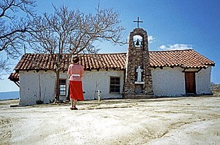
Agua Caliente in Maricopa County, Arizona on the border with Yuma County, is a place north of the Gila River near Hyder, Arizona. Named 'Santa Maria del Agua Caliente' in 1744 by Father Jacob Sedelmayer. In 1775, Father Francisco Garces used the current short form. The location was the site of a resort established at the site of nearby hot springs. Agua Caliente, a name derived from Spanish meaning "hot water", received its name from nearby hot springs which were originally used by the local Indigenous population.
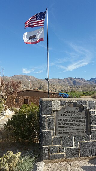
Vallecito, in San Diego County, California, is an oasis of cienegas and salt grass along Vallecito Creek and a former Kumeyaay settlement on the edge of the Colorado Desert in the Vallecito Valley. Its Spanish name is translated as "little valley". Vallecito was located at the apex of the gap in the Carrizo Badlands created by Carrizo Creek and its wash in its lower reach, to which Vallecito Creek is a tributary. The springs of Vallecito, like many in the vicinity, are a product of the faults that run along the base of the Peninsular Ranges to the west.

The Pioneer and Military Memorial Park is the official name given to seven historic cemeteries in Phoenix, Arizona. The cemeteries were founded in 1884 in what was known as "Block 32". On February 1, 2007, "Block 32" was renamed Pioneer and Military Memorial Park. The Pioneer and Military Memorial Park is listed in the National Register of Historic Places. The historic Smurthwaite House, which is also listed in the National Register of Historic Places, is located on the grounds of the Pioneer and Military Memorial Park and is used as the cemetery's main office. Pioneer and Military Memorial Park is the final resting place of various notable pioneers of Arizona.

Gillett, Arizona, is a ghost town in Yavapai County, Arizona, United States. It has an estimated elevation of 1,362 feet (415 m) above sea level. Historically, it was a stagecoach station, and then a settlement formed around an ore mill serving the Tip Top Mine, on the Agua Fria River in Yavapai County in what was then Arizona Territory. It was named for the mining developer of the Tip Top Mine, Dan B. Gillett and is spelled incorrectly as Gillette on U. S. Topographic Maps and elsewhere.
Sundad is an unincorporated area in the far west of Maricopa County, Arizona, United States, along the border of Yuma County. It has an estimated elevation of 965 feet (294 m) above sea level. It is located north of Agua Caliente and east of Sacation Flats.

Trinidad Swilling Shumaker, known as "The Mother of Phoenix" was a pioneer and the wife of Jack Swilling, the founder of Phoenix. Mrs. Swilling was involved in local civic activities and promoted the public recognition of her husband as founder of Phoenix. She was also involved in dispute which made the local news as to who was the first White woman to settle in the Phoenix townsite. In 1868, Swilling founded the first pioneer home in the Salt River Valley.

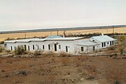 The Agua Caliente Resort.
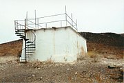 Agua Caliente Resort pump house
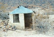 An Agua Caliente shack
 Inside the Agua Caliente shack
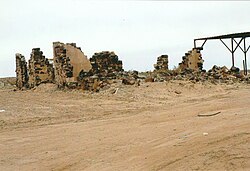
 Stone house ruins
 Stone house ruins
 Stone house ruins
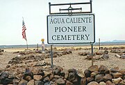 Agua Caliente Pioneer Cemetery
 Lone grave in Agua Caliente
 Equipment used in the Agua Caliente Resort


