Fort Tyson

Last updated
Fort Tyson
(1856)
Quartzsite-Tyson's Well Stage Station-1866-1.jpg
Fort Tyson ruins
AZMap-doton-Quartzsite.png
Location in La Paz County and the state of Arizona
Coordinates: 33°39′54″N114°13′15″W / 33.66500°N 114.22083°W / 33.66500; -114.22083
Country United States
State Arizona
County La Paz
Website Town of Quartzsite

Fort Tyson was a privately owned fort built in 1856 by Charles Tyson in the area which is now called Quartzsite, Arizona. He built the fort to protect the local miners and water supply from the raids of the Yavapai (Mohave-Apache), a Native-American tribe. The area in which Fort Tyson was located has been known as Fort Tyson, Tyson’s Well and is now called the town of Quartzsite because of the large amount of quartz found in its surrounding areas.

Contents

Brief history

Fort Tyson

Charles Tyson was an early settler who saw the mining potential of what in the future was to become the town of Quartzsite. In the early years of the American gold rush, pan handlers began to arrive in Arizona searching for the precious metal. Gold deposits were discovered in the desert mountains of Plomosa and Dome Rock in the area and a boom in the mining industry followed. [1] [2] [3] [4]

Many of the early pioneers and miners who settled the area arrived from California and other places in the United States and abroad. The water supply in the area became the target of the Native-Americans who belonged to the Yavapai tribe (a.k.a. as Mohave-Apache). They resented the arrival of the Anglo-European settlers on their land and raided the early settlements. Charles Tyson therefore, decided to build a fort to protect the settlers and the water supply. He built the fort which became known as Fort Tyson, in 1856. The settlement also became known as Fort Tyson after the fort. [2] [3] [4]

Tyson’s Well and stage station

In 1864, Tyson dug a well, which according to the Quartzsite Historical Society, was dug by hand. Today there is a historical marker on the spot where the well was supposedly dug. Tyson then built a stage station in 1866, which originally served the stage coaches that traveled from the towns of Ehrenberg and Prescott. Prescott at the time was the capital city of the Arizona Territory. The California and Arizona Stage Company began transporting passengers which included prospectors, since gold had been discovered in the mines of Wickenburg and Prescott, and made stops at the station. The Wells Fargo express also stopped by the station en route to Ehrenberg and Wickenburg from California. Tyson’s Well Stage Station became a busy stage coach station since it was located on the famous Butterfield Overland Mail route between Prescott, Arizona and Riverside, California. [2] [3] [4]

Travel by railroad affected the commercial aspect of the area. The town fell under a complete state of abandonment when the stage lines stopped running in the area. However, there was a minor mining boom in 1897, which revitalized the town. That year the town was officially named Quartzsite and Tyson owned three stores, two saloons and a post office. Tyson’s Well stage station continued to provide rest and refreshment to travelers and freight drivers. However, the mining boom faded by 1900 and the town was once more abandoned and left with only 20 residents. [2] [3] [4]

Fort Tyson and Tyson's Well Stage Station

The following gallery has the images of the remains of the original Fort Tyson, Tyson's Well stage station and a replica of the Oasis Hotel:

Images of Quartzsite


Tyson's Well Old Stage Station historic marker. Quartzsite-Tyson's Well Old Stage Station-Marker-2.jpg
Tyson's Well Old Stage Station historic marker.
NameImageYearNameImageYear
1Fort Tyson Ruins Quartzsite-Fort Tyson Ruins-1856-4.jpg 18562Fort Tyson Ruins Quartzsite-Fort Tyson Ruins-1856-5.jpg 1856
3Fort Tyson Ruins Quartzsite-Fort Tyson Ruins-1856-2.jpg 18564Tyson's Well Quartzsite-Tyson's Well-1864-1.jpg 1864
5Tyson's Well Stage Station Quartzsite-Tyson's Well Stage Station-1866-1.jpg 18666Tyson's Well Stage Station Quartzsite-Tyson's Well Stage Station-1866-4.jpg 1866
7Watering well in Tyson's Stage Station Quartzsite-Tyson's Stage Station Well-1866.jpg 18668Oasis Hotel Replica Quartzsite-Oasis Hotel Replica-1900-3.jpg 1900
9Oasis Hotel Replica Quartzsite-Oasis Hotel Replica-1900-2.jpg 1900

Further reading

See also

Quartzsite, Arizona

Related Research Articles

<span class="mw-page-title-main">Yavapai County, Arizona</span> County in Arizona, United States

Yavapai County is near the center of the U.S. state of Arizona. As of the 2020 census, its population was 236,209, making it the fourth-most populous county in Arizona. The county seat is Prescott.

<span class="mw-page-title-main">Quartzsite, Arizona</span> Town in La Paz County, Arizona, US

Quartzsite is a town in La Paz County, Arizona, United States. According to the 2020 census, the population was 2,413.

<span class="mw-page-title-main">Wickenburg, Arizona</span> Town in Maricopa County, Arizona

Wickenburg is a town in Maricopa and Yavapai counties, Arizona, United States. As of the 2020 census, the population of the town was 7,474, up from 6,363 in 2010.

<span class="mw-page-title-main">Prescott Valley, Arizona</span> Town in Yavapai County, Arizona

Prescott Valley is a town located in Yavapai County, Arizona, United States, approximately 8 miles (13 km) east of Prescott. According to the 2020 United States Census, Prescott Valley has a population of 46,785 residents.

<span class="mw-page-title-main">Yarnell, Arizona</span> CDP in Yavapai County, Arizona

Yarnell is a census-designated place (CDP) in Yavapai County, Arizona, United States. The population of Yarnell was 649 at the 2010 census. Yarnell's economy is based on ranching, mining and services to travelers and retirees. Peeples Valley, three miles north, is closely linked to Yarnell.

<span class="mw-page-title-main">Olive Oatman</span> American woman once enslaved (1837–1903)

Olive Ann Oatman was a white American woman celebrated in her time for her captivity and later release by Native Americans in the Mojave Desert region when she was a teenager. She later lectured about her experiences.

<span class="mw-page-title-main">Oatman, Arizona</span> Census-designated place in Mohave County, Arizona, United States

Oatman is a census-designated place (CDP) in the Black Mountains of Mohave County, Arizona, United States, at an elevation of 2,710 feet (830 m). In 1915, it began as a small mining camp when two prospectors struck US$10 million in gold, though the vicinity had already been settled for several years. Oatman's population grew to more than 3,500 in one year. As of the 2020 United States census, its population was 102.

<span class="mw-page-title-main">Jack Swilling</span> American pioneer in the Arizona Territory (1830–1878)

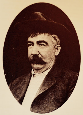
John W. Swilling was an early pioneer in the Arizona Territory. He is commonly credited as one of the original founders of the city of Phoenix, Arizona. Swilling also played an important role in the opening of the central Arizona highlands to white settlement. His discoveries resulted in a gold rush to the region, and this in turn led to the establishment of Arizona's first territorial capital at the mining town of Prescott.

<span class="mw-page-title-main">Yavapai</span> Ethnic Group

The Yavapai are a Native American tribe in Arizona. Historically, the Yavapai – literally “people of the sun” – were divided into four geographical bands who identified as separate, independent peoples: the Ɖulv G’paaya, or Western Yavapai; the Yaavpe', or Northwestern Yavapai; the Gwev G’paaya, or Southeastern Yavapai; and the Wiipukpaa, or Northeastern Yavapai – Verde Valley Yavapai.

<span class="mw-page-title-main">Big Bug, Arizona</span> Ghost town in Yavapai County, Arizona

Big Bug is a ghost town in Yavapai County, Arizona, United States. The former settlement is located twelve miles southeast of Prescott and was established in 1862.

<span class="mw-page-title-main">Yavapai Wars</span> Part of the Apache Wars

The Yavapai Wars, or the Tonto Wars, were a series of armed conflicts between the Yavapai and Tonto tribes against the United States in the Arizona Territory. The period began no later than 1861, with the arrival of American settlers on Yavapai and Tonto land. At the time, the Yavapai were considered a band of the Western Apache people due to their close relationship with tribes such as the Tonto and Pinal. The war culminated with the Yavapai's removal from the Camp Verde Reservation to San Carlos on February 27, 1875, an event now known as Exodus Day.

<span class="mw-page-title-main">Hualapai War</span> 1865–1870, United States v. Natives

The Hualapai War, or Walapai War, was an armed conflict fought from 1865 to 1870 between the Hualapai native Americans and the United States in Arizona Territory. The Yavapai also participated on the side of the Hualapai and Mohave scouts were employed by the United States Army. Following the death of the prominent Yavapai leader Anasa in April 1865, the natives began raiding American settlements which provoked a response by the United States Army forces stationed in the area. By the spring of 1869 disease forced the majority of the Hualapais to surrender though some skirmishing continued for almost two more years.

<span class="mw-page-title-main">Irataba</span> Leader of the Mohave Nation (c. 1814 – 1874)

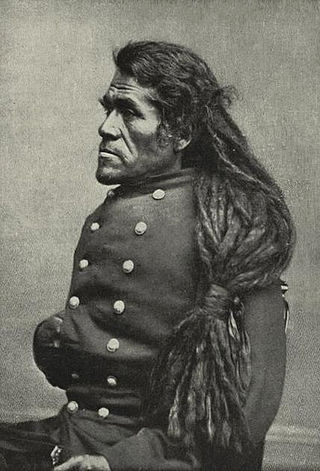
Irataba was a leader of the Mohave Nation, known as a mediator between the Mohave and the United States. He was born near the Colorado River in present-day Arizona. Irataba was a renowned orator and one of the first Mohave to speak English, a skill he used to develop relations with the United States.

Olive City, or Olivia, was a short-lived town, steamboat landing, and ferry crossing on the Colorado River in what was then Yuma County, Arizona Territory, from 1863 to 1866. It was located on the Arizona bank of the Colorado River, 1 mile above its rival Mineral City and 1/2 mile above the original site of Ehrenberg, Arizona, 3 miles southwest of the location of La Paz. The GNIS location of Olive City (historical) is indicated as being in La Paz County, Arizona, but its coordinates in the present-day now put it across the river just within Riverside County, California. Olive City was named after Olive Oatman who had been, with her sister, survivors of the massacre of her family and a captive of the Yavapai until purchased from them by the Mohave who they lived with for several years.

<span class="mw-page-title-main">Joe Mayer</span> Arizona pioneer (1846–1909)

Joseph Mayer was an American businessman, gold prospector and pioneer who founded the town of Mayer, Arizona.

References