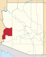
Pah-Ute County is a former county in the northwest corner of Arizona Territory that existed from 1865 until 1871, at which point most of the area was transferred to Nevada. The remainder was merged into Mohave County. The majority of the territory is now in Clark County, Nevada, which includes the city of Las Vegas. Due to the transfer of most of the county's land to Nevada, Pah-Ute is sometimes referred to as Arizona's "Lost County". Pah-Ute is an historic spelling of the tribal name Paiute.

La Paz was a short-lived, early gold mining town along the Colorado River in La Paz County on the western border of the U.S. state of Arizona. It was the location of the La Paz Incident in 1863, the westernmost confrontation of the American Civil War. The town was settled in 1862 in New Mexico Territory, before the Arizona Territory was officially declared a United States territory by President Abraham Lincoln. Today it is a deserted ghost town. In 1983, long after the town was deserted, the name was adopted by the newly formed Arizona county of La Paz. La Paz is Spanish for "peace"; the town was presumably named after another earlier town named La Paz, such as La Paz, Bolivia, or La Paz, Baja California Sur.

Castle Dome Landing, Arizona is a ghost town in the Castle Dome Mountains of Yuma County in the U.S. state of Arizona. It was first settled as a transport depot and mining camp around 1863 in what was then the Arizona Territory.

Aubrey Landing, Aubrey City or Aubrey is a ghost town at the mouth of the Bill Williams River in southern Mohave County, Arizona. The town was founded before 1865 and was abandoned sometime after 1886. Aubrey Landing was inundated when Lake Havasu was formed.

Port Isabel was a seaport established on Port Isabel Slough in 1865 during the American Civil War in Sonora, Mexico in the mouth of the Colorado River on the Gulf of California. It was founded to support the increased river traffic caused by the gold rush that began in 1862 on the Colorado River and the Yuma Quartermaster Depot newly established in 1864 to support the Army posts in the Arizona Military District. The slough was discovered in 1865 by the Captain W. H. Pierson of the schooner Isabel, that first used the slough to transfer its cargo to steamboats safe from the tidal bore of the Colorado River. Shortly afterward Port Isabel was established 3 miles up the slough and replaced Robinson's Landing as the place where cargo was unloaded in the river from seagoing craft on to flat bottomed steamboats of the Colorado River and carried up to Fort Yuma and points further north on the river.
El Dorado Canyon is a canyon in southern Clark County, Nevada famed for its rich silver and gold mines. The canyon was named in 1857 by steamboat entrepreneur Captain George Alonzo Johnson when gold and silver was discovered here. It drains into the Colorado River at the former site of Nelson's Landing.

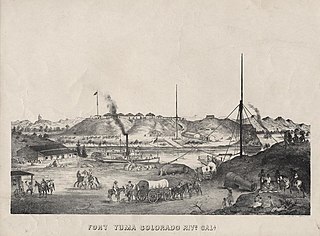
Steamboats on the Colorado River operated from the river mouth at the Colorado River Delta on the Gulf of California in Mexico, up to the Virgin River on the Lower Colorado River Valley in the Southwestern United States from 1852 until 1909, when the construction of the Laguna Dam was completed. The shallow draft paddle steamers were found to be the most economical way to ship goods between the Pacific Ocean ports and settlements and mines along the lower river, putting in at landings in Sonora state, Baja California Territory, California state, Arizona Territory, New Mexico Territory, and Nevada state. They remained the primary means of transportation of freight until the advent of the more economical railroads began cutting away at their business from 1878 when the first line entered Arizona Territory.
The Union Line was a transport company of steamboats of the Colorado River, owned by Thomas E. Trueworthy, operating in southeastern California, western Arizona Territory, and northwestern Mexico.
El Dorado City, which is now a ghost town, was a mining camp in the Colorado Mining District at the mouth of January Wash at its confluence with El Dorado Canyon. It was located about a mile down the canyon from Huse Spring, at an elevation of 2382 feet. Its site was located nearby to the south southeast of the Techatticup Mine the primary source of the ore its mill processed.
Colorado City is now a ghost town, in Clark County, Nevada, located under Lake Mohave at the mouth of El Dorado Canyon.

Bradshaw's Ferry was a ferry at the crossing point on the Colorado River, of the Bradshaw Trail at Olive City and later at Mineral City and Ehrenburg, between what was then San Diego County, California and Arizona County, New Mexico Territory. The ferry connected the Bradshaw Trail to the road to the gold placers of La Paz, the first big strike of the Colorado River Gold Rush. From 1863, the La Paz - Wikenburg Road connected the Bradshaw Trail to the new mining boom town settlements in the interior of Arizona Territory.
Hualapai Smith's or Smith’s Ferry was a steamboat landing and a ferry crossing and farm on the Sonora bank of the Colorado River, the border between Sonora and Baja California, from the later 1860s to 1878. It was located on the Colorado River in Sonora 20 miles overland from Yuma, Arizona and 30 miles down river from Fort Yuma in 1861.

Olive City, or Olivia, was a short-lived town, steamboat landing, and ferry crossing on the Colorado River in what was then Yuma County, Arizona Territory, from 1863 to 1866. It was located on the Arizona bank of the Colorado River, 1 mile above its rival Mineral City and 1/2 mile above the original site of Ehrenberg, Arizona, 3 miles southwest of the location of La Paz. The GNIS location of Olive City (historical) is indicated as being in La Paz County, Arizona, but its coordinates in the present-day now put it across the river just within Riverside County, California Olive City was named after Olive Oatman who had been, with her sister, survivors of the massacre of her family and a captive of the Yavapai until purchased from them by the Mohave who they lived with for several years.
Colorado Mining District was primarily a silver and gold mining district organized in El Dorado Canyon, New Mexico Territory on the west shore of the Colorado River in what is now Clark County, Nevada. The Colorado District was part of Arizona Territory from 1863 to 1869. In 1869, the land of Arizona Territory north and west of the Colorado River east to the 114th meridian of longitude, including the Colorado District, was turned over to Nevada.

Empire Flat was a steamboat landing at Empire Flat on the east shore of the Colorado River, within Parker Strip, Arizona, in La Paz County, Arizona.
George A. Johnson & Company was a partnership between three men who pioneered navigation on the Colorado River. Benjamin M. Hartshorne, George Alonzo Johnson and Alfred H. Wilcox. The George A. Johnson & Company was formed in the fall of 1852, and was reorganized as the Colorado Steam Navigation Company in 1869.
Iretaba City a short lived steamboat landing and mining town, in Mohave County, Arizona.
Clip, or Clip Landing, was a steamboat landing and mill settlement in Yuma County, Arizona Territory. The site in the present day is a ghost town, on the east bank of the Colorado River in La Paz County, Arizona. The settlement was located 70 miles up river from Yuma. It lies at an elevation of 223 feet, just south of Clip Wash, and the road to the Clip Mine at the top of the wash, 8 miles southeast of the mill.
La Paz–Wikenburg Road was a 131-mile-long (211 km) wagon road from 1863 and from 1866 a stagecoach route between the Colorado River landings at La Paz, Olive City and Mineral City to the mining town of Wickenburg, Arizona. From Wickenburg roads led to other new mining camps and districts in the interior of Arizona Territory. From 1862, when the river changed its course, La Paz was isolated on the slough of the old river channel over four miles (6.4 km) from the new river channel. In 1866, the road head changed to the new river landing of Ehrenburg, where the Bradshaw Trail wagon and stagecoach road from San Bernardino, California, crossed the Colorado River at Bradshaw's Ferry.


