
La Paz County is a county in the western part of the U.S. state of Arizona. As of the 2010 census, its population was 20,489, making it the second-least populous county in Arizona. The county seat is Parker. The name of the county is the Spanish word for "the peace", and is taken from the early settlement of La Paz along the Colorado River.

Mohave County is in the northwestern corner of the U.S. state of Arizona. As of the 2010 census, its population was 200,186. The county seat is Kingman, and the largest city is Lake Havasu City. It is the fifth largest county in the United States.

Hidalgo County (; Spanish pronunciation: [iˈð̞alɣ̞o]) is located in the U.S. state of Texas. The county seat is Edinburg and the largest city is McAllen. The county is named for Miguel Hidalgo y Costilla, the priest who raised the call for Mexico's independence from Spain. It is located in the Rio Grande Valley of South Texas and is one of the fastest-growing counties in the United States. As of the 2010 census, the population of Hidalgo County was 774,769, making it the eighth-most populous county in Texas. Hidalgo County is designated by the U.S. Census Bureau as the McAllen-Edinburg-Mission metropolitan statistical area, which itself is part of the McAllen-Edinburg-Mission-Rio Grande City, Texas combined statistical area with neighboring Starr County.

Los Alamos County is a county in the U.S. state of New Mexico. As of the 2010 census, the population was 17,950. The smallest county in area of this state was administered exclusively by the U.S. federal government during the Manhattan Project, but now has equal status to New Mexico's other counties. The county has two census-designated places: Los Alamos and White Rock.

Bluewater is a census-designated place (CDP) on the Colorado River Indian Reservation in La Paz County, Arizona, United States. The population was 725 at the 2010 census.

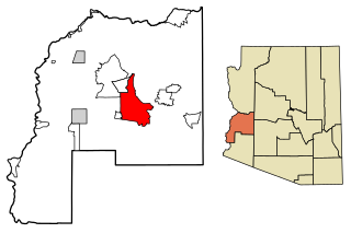
Bouse is a census-designated place (CDP) in La Paz County, Arizona, United States. Founded in 1908 as a mining camp, the economy of Bouse is now based on tourism, agriculture, and retirees. The population was 996 at the 2010 census.

Parker Strip is a census-designated place (CDP) in La Paz County, Arizona, United States. The population was 662 at the 2010 census.

Alamo is an unincorporated community and census-designated place (CDP) in Contra Costa County, California, in the United States. It is a suburb located in the San Francisco Bay Area's East Bay region, approximately 28 miles (45 km) east of San Francisco. Alamo is equidistant between the city of Walnut Creek and the incorporated town of Danville. As of the 2010 census, the population was 14,750. The community of Alamo is well known for its bucolic country feel, notable residents, and its affluent lifestyle with the median home price being $2.43 million.

Eldorado at Santa Fe is a census-designated place (CDP) in Santa Fe County, New Mexico, United States. It is part of the Santa Fe, New Mexico Metropolitan Statistical Area. The population was 6,130 at the 2010 census.
Alamo is a census-designated place (CDP) in Socorro County, New Mexico, United States. The population was 1,085 at the 2010 census. It is the largest community on the Alamo Navajo Indian Reservation.

Alamo, located in the Rio Grande Valley in what is nicknamed the "Land of Two Summers", is a city in the irrigated area of southern Hidalgo County, Texas, United States. Known as the "Refuge to the Valley", it is located in an area of abundant vegetable farming and citrus groves, and is a noted winter resort/retirement town near the Mexico–U.S. border. Alamo is one of the Rio Grande Valley's gateways to Mexico, via U.S. Route 281 and Nuevo Progreso, Tamaulipas, as well as a gateway to the Santa Ana National Wildlife Refuge. Alamo's population was 18,353 at the 2010 census and an estimated 19,910 in 2019.
Fish Lake is an unincorporated community and census-designated place in Lincoln Township, LaPorte County, Indiana, United States. It is located where Indiana State Road 4 passes between Upper Fish Lake and Lower Fish Lake. These lakes feed the Kankakee River. As of the 2010 census, the population of the community was 1,016.

Hudson Lake is an unincorporated community and census-designated place (CDP) in Hudson Township, LaPorte County, Indiana, United States. The town sits on the dividing line between Central and Eastern time zones. It is the site of the Hudson Lake station stop of the South Shore Line. As of the 2010 census, the population of the CDP was 1,297.

Brenda is an unincorporated community and census-designated place (CDP) in La Paz County, Arizona, United States. It is located approximately 16 miles (26 km) east of Quartzsite and 4 miles (6 km) northeast of Interstate 10 on U.S. Route 60. Its population was 466 as of the 2020 census. The community lies 5 miles (8 km) east of the Plomosa Mountains, and it is the closest community to the New Water Mountains Wilderness, five air miles to the south. Brenda is four miles northeast of the western terminus of US 60.

Lake Holiday is a census-designated place located on Lake Holiday in Northville Township, LaSalle County, Illinois, United States. Its population was 4,761 as of the 2010 census.
Vicksburg is a census-designated place in La Paz County, Arizona, United States. Its population was 418 as of the 2020 census. The community was named for Victor E. Satterdahl, who applied for its post office and served as the first postmaster once it opened in 1906.

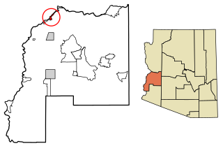
Utting is a census-designated place in La Paz County, Arizona, United States. As of the 2010 census, its population was 126. The community was named after Charles Utting, who fought with the Rough Riders in the Spanish–American War.
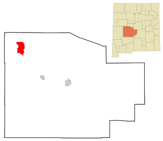
Cienega Springs is a census-designated place in La Paz County, Arizona, United States. Its population was 1,690 as of the 2020 census.

La Paz Valley is a census-designated place (CDP) in La Paz County, Arizona, United States. Its population was 368 as of the 2020 census. The community is in western La Paz County and is bordered to the north by the town of Quartzsite. To the south it is bordered by Yuma County.

Sunwest is a census-designated place in La Paz County, Arizona, United States. Its population was 5 as of the 2020 census.


