Sunwest, Arizona

Last updated
Sunwest, Arizona
La Paz County Arizona Incorporated and Unincorporated areas Sunwest Highlighted 0471220.svg
Location in La Paz County, Arizona
USA Arizona location map.svg
Red pog.svg
Sunwest
Location in La Paz County, Arizona
Usa edcp location map.svg
Red pog.svg
Sunwest
Sunwest (the United States)
Coordinates: 33°39′04″N113°24′33″W / 33.65111°N 113.40917°W / 33.65111; -113.40917 Coordinates: 33°39′04″N113°24′33″W / 33.65111°N 113.40917°W / 33.65111; -113.40917
Country United States
State Arizona
County La Paz
Area
[1]
  Total24.25 sq mi (62.80 km2)
  Land24.25 sq mi (62.80 km2)
  Water0.00 sq mi (0.00 km2)
Elevation
1,503 ft (458 m)
Population
 (2020)
  Total5
  Density0.21/sq mi (0.08/km2)
Time zone UTC-7 (Mountain (MST))
Area code(s) 928
GNIS feature ID2582873 [2]
FIPS code 04-71220

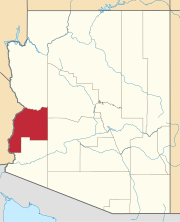
Sunwest is a census-designated place in La Paz County, Arizona, United States. Its population was 5 as of the 2020 census.

Demographics

Historical population
CensusPop.
2020 5
U.S. Decennial Census [3]

Related Research Articles

A census-designated place (CDP) is a concentration of population defined by the United States Census Bureau for statistical purposes only. CDPs have been used in each decennial census since 1980 as the counterparts of incorporated places, such as self-governing cities, towns, and villages, for the purposes of gathering and correlating statistical data. CDPs are populated areas that generally include one officially designated but currently unincorporated community, for which the CDP is named, plus surrounding inhabited countryside of varying dimensions and, occasionally, other, smaller unincorporated communities as well. CDPs include small rural communities, edge cities, colonias located along the Mexico–United States border, and unincorporated resort and retirement communities and their environs.

Mashantucket, Connecticut Census-designated place in Connecticut, United States

Mashantucket is a census-designated place (CDP) in the northeast part of the town of Ledyard, New London County, Connecticut, United States. It consists of land held by the Mashantucket Pequot Tribe. The Foxwoods Resort Casino is in the northeast part of the CDP, along Connecticut Route 2. As of the 2010 census, the CDP had a population of 299.

Blacksburg–Christiansburg metropolitan area

The Blacksburg-Christiansburg Metropolitan Statistical Area, formerly the Blacksburg-Christiansburg-Radford Metropolitan Statistical Area, is a Metropolitan Statistical Area (MSA) as defined by the United States Office of Management and Budget (OMB) located in the New River Valley of Southwest Virginia. As of the 2010 census, the MSA had a population of 162,958.

Roanoke metropolitan area

The Roanoke Metropolitan Statistical Area is a Metropolitan Statistical Area (MSA) in Virginia as defined by the United States Office of Management and Budget (OMB). The Roanoke MSA is sometimes referred to as the Roanoke Valley, even though the Roanoke MSA occupies a larger area than the Roanoke Valley. It is geographically similar to the area known as the Roanoke Region of Virginia, but while the latter includes Alleghany County, the former does not. As of the 2000 census, the MSA had a population of 288,309.

Fort Smith metropolitan area

The Fort Smith Metropolitan Statistical Area, as defined by the United States Census Bureau, is a five-county area including three Arkansas counties and two Oklahoma counties, and anchored by the city of Fort Smith, Arkansas. The total MSA population in 2000 was 273,170 people, estimated by the Bureau to have grown to 289,693 people by 2007.

Baton Rouge metropolitan area Metropolitan area in Louisiana, United States

The Baton Rouge metropolitan statistical area, as defined by the United States Office of Management and Budget, or simply the Baton Rouge metropolitan area or Greater Baton Rouge, is a sprawling metropolitan statistical area surrounding the city of Baton Rouge. Its principal city Baton Rouge is unusual because it has no major incorporated satellite cities, a rarity for a metropolitan area of its size. Comprising the western edge of the Florida Parishes regions, it is known as "Plantation Country", the "Capital Region", and "The 225". At the 2010 U.S. census, the metropolitan area had a population of 802,484, up from 705,973 in 2000. At the 2020 census, its population increased to 870,569, up from 2020 estimates at 858,571.

Knoxville metropolitan area Metropolitan area in Tennessee, United States

The Knoxville metropolitan area, commonly known as Greater Knoxville, is a metropolitan statistical area centered on Knoxville, Tennessee, the third largest city in Tennessee and the largest city in East Tennessee. It is the third largest metropolitan area in Tennessee. In 2020, the metro area had a population of 879,773. The Knoxville–Morristown–Sevierville Combined Statistical Area had a population of 1,156,861 according to the census bureau in 2020.

A designated place (DPL) is a type of community or settlement identified by Statistics Canada that does not meet the criteria used to define municipalities or population centres. DPLs are delineated every 5 years for the Canadian census as the statistical counterparts of incorporated places such as cities, towns, and villages.

The Salisbury, MD-DE Metropolitan Statistical Area, as defined by the United States Census Bureau is a metropolitan area centered on the city of Salisbury, Maryland and consists of four counties: Somerset, Wicomico, and Worcester in Maryland and Sussex in Delaware. The MSA had a total population of 423,481 residents as of the 2020 Census. The United States Census Bureau also defines the Salisbury-Cambridge, MD-DE Combined Statistical Area which combines the Salisbury metropolitan area with the Cambridge, Maryland Micropolitan Statistical Area.

Alamo Lake, Arizona CDP in La Paz County, Arizona

Alamo Lake is a census-designated place in La Paz County, Arizona, United States. Its population was 4 as of the 2020 census. The community includes Alamo Lake State Park.

Savannah metropolitan area Savannah–Hinesville–Statesboro–Jesup Combined Statistical Area in Georgia, United States

The Savannah metropolitan area is centered on the principal city of Savannah, Georgia. The official name given by the U.S. Office of Management and Budget (OMB) is the Savannah, GA Metropolitan Statistical Area, which is used for statistical purposes by the United States Census Bureau and other entities. The OMB defines this area as consisting of Bryan, Chatham, and Effingham counties in Georgia; its total population was 404,798 in the official 2020 U.S. Census, compared to 347,611 in the 2010 census. The Savannah MSA is the third most populous of fourteen Georgia MSAs. Savannah was the fastest-growing metropolitan area in Georgia for the period 2010–2020.

References

  1. "2020 U.S. Gazetteer Files". United States Census Bureau. Retrieved October 29, 2021.
  2. "Sunwest Census Designated Place". Geographic Names Information System . United States Geological Survey.
  3. "Census of Population and Housing". Census.gov. Retrieved June 4, 2016.