Weedville, Arizona

Last updated
Weedville, Arizona
Peoria-Weedvillie-Weed Family.jpg
Rev. Ora Rush Weed and his family in front of their home in 1912.
USA Arizona location map.svg
Red pog.svg
Weedville
Usa edcp location map.svg
Red pog.svg
Weedville
Coordinates: 33°36′50″N112°12′56″W / 33.61389°N 112.21556°W / 33.61389; -112.21556
Country United States
State Arizona
County Maricopa
Elevation
[1]
1,197 ft (365 m)
Time zone UTC-7 (Mountain (MST))
  Summer (DST) UTC-7 (MST)
ZIP codes
85381
Area code 623
FIPS code 04-81410
GNIS feature ID 13436

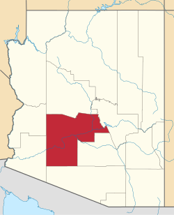
Weedville is a populated place situated within the city limits of Peoria in Maricopa County, Arizona, United States. [2] It was a small community founded in 1911, in an area which, at the time, was outside the city limits of Peoria. The area is located within the pockets of unincorporated land under the jurisdiction of Maricopa County. All of the census and demographic data for the residents of Weedville are part of the information reported for the city of Peoria, since Weedville is located within the limits of that city.

Contents

History

Reverend Ora Rush Weed (1868–1942) was a Methodist minister from Kansas. It is unknown why Weed decided to leave his hometown with his wife Phoebe and family. They moved and settled in Arizona. Some of the members of his Kansas ministry followed him and together they homesteaded the area north of Thunderbird Road and 75th Avenue, outside of what at the time were the city limits of Peoria. [3] [4] [5]

By 1916, Weed established the Path Church (now known as the "Old Path Church") and a boarding school. The name "Paths" comes from a Bible verse (Jeremiah 6:16): "Stand ye in the ways, and see, and ask for the old paths, where is the good way, and walk therein, and ye shall find rest for your souls." [6] A small religious community flourished around the development of Weedville, which Weed named after himself. By 1921, the community established a cemetery which was named the Old Paths Cemetery. [3] [4] [5] Besides running a small general store, Weed ran a farm which produced broom grass. He then established a broom factory using the broom grass. He employed many ex-convicts who had gained experience as broom makers in prison. As such the factory helped support the small community economically. [3]

Later years

Weed donated land and buildings for the establishment of the Southwest Indian School. Today the site is home to the Southwest Indian School Ministries. The Old Path Church is still standing and is located within the grounds of the ministry. Rev. Ora Weed died on May 4, 1942. He and many of his descendants are buried in the Old Paths Cemetery which is located on the Old Paths Cemetery Road. The original bell of the Old Path Church is located within the grounds of the Old Paths Cemetery. The bell is rung every Veterans Day [3] [4] [5] [7]

Weedville is located in the area within 71st and 75th avenues. between Thunderbird Boulevard and Acoma Drive. The latitude is 33.614 and the longitude −112.215. The elevation of Weedville is 1,197 feet above mean sea level. [5]

Historic structures of Weedville

Old Paths Cemetery

The Old Paths Cemetery is a small private cemetery located in "Weedville" and named for its founder Reverend Ora Weed. The cemetery is located north of the northeast corner of 73rd Ave. & Thunderbird Road. The majority of Weedville, including the Old Paths Cemetery, lies in unincorporated land. The cemetery has been maintained with care by the Weed family since its founding in 1921.

In pop culture

Arizona Republic writer Jim Cook had a chapter on Weedville in his 2002 book, "Arizona Liars Journal", published by Cowboy Miner Productions; ISBN   978-1931725033. [3] [4] [5]

See also

Related Research Articles

<span class="mw-page-title-main">Peoria, Arizona</span> City in Arizona, United States

Peoria is a city in Maricopa and Yavapai counties in the U.S. state of Arizona. Most of the city is located in Maricopa County, while a portion of it in the north is in Yavapai County. It is a major suburb of Phoenix. As of the 2020 census, the population of Peoria was 190,985, up from 154,065 in 2010. It is the sixth-largest city in Arizona in land area and the ninth-largest in population. It was named after Peoria, Illinois. The word peoria is a corruption of the Miami-Illinois word for "prairie fire". It is the spring training home of the San Diego Padres and Seattle Mariners, who share the Peoria Sports Complex.

<span class="mw-page-title-main">North/Northwest Phoenix</span> Region of the city

North/Northwest Phoenix is a region in the city of Phoenix, Arizona. While the area with this name has no official separate status, it usually refers to the Urban Villages of Paradise Valley, North Mountain, Deer Valley, Desert View, and North Gateway.

<span class="mw-page-title-main">Morristown, Arizona</span> CDP in Maricopa County, Arizona

Morristown is an unincorporated community and census-designated place (CDP) in Maricopa County, Arizona, United States. It is 43 miles (69 km) northwest of Phoenix, at the junction of State Route 74 and U.S. Route 60. As of the 2020 census, it had a population of 186, down from 227 in 2010.

<span class="mw-page-title-main">Liberty, Arizona</span> Unincorporated community in the state of Arizona, United States

Liberty is a small populated place in Maricopa County, Arizona, United States. It is located about 30 miles west of Phoenix and about 6 miles southeast of Buckeye. Liberty is located at the intersection of South Jackrabbit Trail and West Baseline Road. It is located entirely within Block 3017, Block Group 3, Census Tract 506.01, Maricopa County, Arizona, which had a population of 63 at the 2000 census.

<span class="mw-page-title-main">Rio Vista Pond</span> Lake in Peoria, Maricopa County, Arizona

Rio Vista Pond is located in Rio Vista Park in south central Peoria, Arizona, United States, on Rio Vista Boulevard, just north of Thunderbird Road.

Many arterial roads in the Phoenix metropolitan area have the same name in multiple cities or towns. Some roads change names or route numbers across town borders, resulting in occasional confusion. For example, the road known as Apache Boulevard in Tempe continues east as Main Street in neighboring Mesa and then as Apache Trail in Apache Junction. Although Broadway Road maintains the same name through Goodyear, Avondale, Phoenix, Tempe, Mesa, and Apache Junction, each town uses a different reference point for address numbers.

<span class="mw-page-title-main">William John Murphy</span> Founder of Glendale, Arizona (1839–1923)

William John Murphy was an American businessman, contractor, land developer and founder of the Arizona Improvement Company. He is also remembered as the "Founder of Glendale, Arizona" and an important contributor to much of the early development in the Phoenix area.

<span class="mw-page-title-main">Pioneer and Military Memorial Park</span> United States historic place in Phoenix, Arizona

The Pioneer and Military Memorial Park is the official name given to seven historic cemeteries in Phoenix, Arizona. The cemeteries were founded in 1884 in what was known as "Block 32". On February 1, 2007, "Block 32" was renamed Pioneer and Military Memorial Park. The Pioneer and Military Memorial Park is listed in the National Register of Historic Places. The historic Smurthwaite House, which is also listed in the National Register of Historic Places, is located on the grounds of the Pioneer and Military Memorial Park and is used as the cemetery's main office. Pioneer and Military Memorial Park is the final resting place of various notable pioneers of Arizona.

<span class="mw-page-title-main">Ora Rush Weed</span> Arizona pioneer (1868–1942)

Ora Rush Weed was a Methodist minister who founded Weedville, a small farming community in Arizona. Weedville's utilities are provided by the City of Peoria. The area is unincorporated which means that the land is not governed by Peoria, the local municipal corporation, instead it is administered by the county.

<span class="mw-page-title-main">Glendale Memorial Park Cemetery</span> Historic cemetery in Maricopa County, Arizona

The Glendale Memorial Park Cemetery is a historic cemetery located at 7844 North 61st Avenue in Glendale, Arizona. The cemetery was originally called Glendale Memorial Park. It is the final resting place of various notable early citizens of Glendale. Among those who are interred in the cemetery are early pioneers, mayors, businessman and veterans who fought in every military conflict in which the United States has been involved starting from the American Civil War onward. Also, in the cemetery there is a memorial and 16 graves of immigrant farmers who perished in 1959, in a bus accident on Central Avenue.

<span class="mw-page-title-main">Home Mission Cemetery</span> Historic cemetery in Maricopa County, Arizona, United States

The Home Mission Cemetery is a historic cemetery located on West Dove Wing Way in the Maricopa County of Arizona, United States, slightly outside of the Surprise town border. The cemetery is also known as the "Sleeping Bride Cemetery" and the "Thompson Cemetery". The Pioneers' Cemetery Association (PCA) defines a "historic cemetery" as one which has been in existence for more than fifty years.

References

Further reading

Commons-logo.svg Media related to Weedville, Arizona at Wikimedia Commons