 The remaining ruins of the Fort McDowell officers quarters located in Ba Hon Nah Road.
 Fort McDowell ruins located in Fort Loop Road.
 The ruins of one of the buildings which belonged to the original Fort McDowell.
 Fort McDowell Church located in Fort Loop Road.
 Abandoned house in the land of the Fort McDowell Yavapai Nation.
 Yavapai resting area.
 Deer Head on top of the Yavapai resting area.
 Entrance of the as "Ba Dah Mod Jo" Cemetery also known as the Fort McDowell Yavapai Nation Cemetery.
 The grave of Carlos Montezuma or Wassaja in "Ba Dah Mod Jo" Cemetery. Montezuma was a Yavapai-Apache Native American, activist and a founding member of the Society of American Indians. His birth name Wassaja, means "Signaling" or "Beckoning" in his native tongue. He was the first Native American male to receive a medical degree.
 The grave of Mike Burns, whose real name was Hoo-moo-thy-ah. He was the cousin of Carlos Montezuma. When he was a child he led the US Cavalry to Skeleton Cave where he witnessed the massacre of his people.
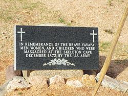 Grave dedicated to the men, women and children who were massacred by the soldiers of the US Army in Skeleton Cave.
 Unidentified graves of the Yavapai who perished during the "Indian Wars”.
 Dr. Carlos Montezuma plaque.
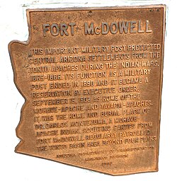
 Marker which indicates where the historic Camp Reno was located.
 Camp Reno ruins. Camp Reno was a lookout post for Fort McDowell.
Fort McDowell, Arizona | |
|---|---|
 Location where Fort McDowell once stood | |
 Fort McDowell  Fort McDowell | |
| Coordinates: 33°38′12″N111°40′28″W / 33.63667°N 111.67444°W | |
| Country | United States |
| State | Arizona |
| County | Maricopa |
| Elevation | 1,440 ft (439 m) |
| Population | |
• Total | 600 |
| Time zone | UTC-7 (Mountain (MST)) |
| • Summer (DST) | UTC-7 (MST) |
| ZIP code | 85264 |
| Area code | 480 |
| FIPS code | 04-24810 |
| GNIS feature ID | 29117 |
| Part of a series of the |
| Cities, towns and CDPs in Arizona with lists and images of historic properties, forts, cemeteries or historic districts |
|---|
 |
Fort McDowell is an unincorporated community in Maricopa County, Arizona, United States. Fort McDowell is 23 miles northeast of Phoenix. Fort McDowell has a post office with ZIP code 85264. [2] It is part of the Fort McDowell Yavapai Reservation. [3]


