Stoneman Military Trail

Last updated
"Stoneman Military Trail" in the Black Mountain of Cave Creek Cave Creek-Stoneman Military Trail-Black Mountains-1865.jpg
"Stoneman Military Trail" in the Black Mountain of Cave Creek

The Stoneman Road, an important supply road between Fort McDowell and Fort Whipple in Prescott between 1870 and 1890. It was an important conduit for the shipping of supplies from Fort Whipple in Prescott to Fort McDowell on what is today the Yavapai Reservation near Fountain Hills.

Fort McDowell, Arizona Unincorporated community in Arizona, United States

Fort McDowell is an unincorporated community in Maricopa County, Arizona, United States. Fort McDowell is 23 miles northeast of Phoenix, Arizona. Fort McDowell has a post office with ZIP code 85264.

Fort Whipple was a U.S. Army post which served as Arizona Territory's capital prior to the founding of Prescott, Arizona. It was named after Amiel Weeks Whipple, a Civil War Union General. The post was founded by Edward Banker Willis in December 1863 in Del Rio Springs, but was moved in May 1864 to a miner's tent settlement called Granite City, which was on higher ground, had better access to lumber, and the military could better protect miners. The capital was placed 2 miles south in the new city of Prescott founded in 1864.

Prescott, Arizona City in Arizona, United States

Prescott is a city in Yavapai County, Arizona, United States. According to the 2010 Census, the population of the city is 39,843. The city is the county seat of Yavapai County. In 1864 Prescott was designated as the capital of the Arizona Territory, replacing the temporary capital at Fort Whipple. The Territorial Capital was moved to Tucson in 1867. Prescott again became the Territorial Capital in 1877, until Phoenix became the capital in 1889.

Contents

History

The Black Mountain in Cave Creek Cave Creek-Stoneman Military Trail-Black Mountains-1865-2.jpg
The Black Mountain in Cave Creek
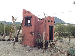
Ruins along the Stoneman Mountain Trail. Cave Creek-Stoneman Military Trail-Black Mountains ruins-1865.jpg
Ruins along the Stoneman Mountain Trail.

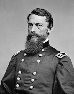
Established in 1865, Fort McDowell was continuously short on supplies and before the Stoneman Road was established, the shortages were especially acute as the connection between the forts required a long route that swung south through Phoenix and north to Prescott. With the establishment of the Stoneman Road, a day’s ride was eliminated from the trip. The new route was named after forty-eight-year-old Colonel George Stoneman, a Civil War veteran and career Army man by way of West Point. He was assigned to Arizona in May, 1870 and although he was relieved of his Arizona duties one year later, his establishment of the road between Fort McDowell and Fort Whipple was a major accomplishment of his brief command. Stoneman was a trailblazer and sought a way to Prescott that would avoid the southern route. He found his route by following an old Indian trail that covered part of the distance. The trail was widened into a rocky road that led northwest from Fort McDowell through what is now McDowell Mountain Regional Park, and passed to the north of Pinnacle Peak. It’s believed that soldiers may have camped in the area which is now near 136th Street and Rio Verde Drive. [1] [2] [3]

Phoenix, Arizona State capital city in Arizona, United States

Phoenix is the capital and most populous city of Arizona, with 1,626,078 people. It is also the fifth most populous city in the United States, and the most populous American state capital, and the only state capital with a population of more than one million residents.

George Stoneman Union Army general and governor

George Stoneman Jr. was a United States Army cavalry officer, trained at West Point, where his roommate was Stonewall Jackson. In the Civil War he became Adjutant to George B. McClellan, who did not appreciate the use of centralized cavalry, and was therefore outperformed by the Confederates, who did.

American Civil War Civil war in the United States from 1861 to 1865

The American Civil War was a war fought in the United States from 1861 to 1865, between the North and the South. The Civil War is the most studied and written about episode in U.S. history. Primarily as a result of the long-standing controversy over the enslavement of black people, war broke out in April 1861 when secessionist forces attacked Fort Sumter in South Carolina shortly after Abraham Lincoln had been inaugurated as the President of the United States. The loyalists of the Union in the North proclaimed support for the Constitution. They faced secessionists of the Confederate States in the South, who advocated for states' rights to uphold slavery.

The road then passed near what would later become Brown’s Ranch and eventually touched the eastern boundary of the area where The Boulder’s resort is located today in north Scottsdale. From there it went past the northern slope of Black Mountain and continued west to Cave Creek. A bubbling spring near what is now Rancho Manana, provided a nice respite for weary travelers. After that it was north along the banks of Cave Creek and crossing into what is now Cave Creek Regional Park. From there it passed through the New River Mountains and Black Canyon, then went north through Mayer to Fort Whipple and Prescott. [1] [2] [3]

Scottsdale, Arizona City in Arizona, United States

Scottsdale is a city in the eastern part of Maricopa County, Arizona, United States, part of the Greater Phoenix Area. Named Scottsdale in 1894 after its founder Winfield Scott, a retired U.S. Army chaplain, the city was incorporated in 1951 with a population of 2,000. The 2015 population of the city was estimated to be 236,839 according to the U.S. Census Bureau. The New York Times described downtown Scottsdale as "a desert version of Miami's South Beach" and as having "plenty of late night partying and a buzzing hotel scene." Its slogan is "The West's Most Western Town."

Cave Creek, Arizona Town in Arizona, United States

Cave Creek is a town in Maricopa County, Arizona, United States. The largest city it borders is Phoenix, Arizona. According to the 2010 census, the population of the town was 5,015.

New River Mountains

The New River Mountains are a small 14-mi (23 km) long, mountain range in central Arizona, and on the north border of the Phoenix valley; the range is located on the southwest perimeter of the Arizona transition zone. The range is a sub-part of landforms extending south from the Black Hills of Yavapai County. Rivers and canyons border east and west; the south of the range is located in Maricopa County, the location of much of the Phoenix metropolitan area.

Evacuation Of Fort McDowell

Raod sign which indicates where the Stoneman Military passed through Cave Creek-Stoneman Military Trail-Black Mountains-road sign-1865.jpg
Raod sign which indicates where the Stoneman Military passed through

On April 10, 1890, Fort McDowell was vacated by the US military and became the Fort McDowell Indian Reservation which served the Mohave, Pima, and Apache tribes. As far as the Stoneman Road, with the lack of traffic on it after 1890 combined with the attrition of time and the Arizona weather, only minimal traces are left. [1] [2] [3]

Fort McDowell Yavapai Nation federally recognized tribe living near Scottsdale and Phoenix, Arizona

The Fort McDowell Yavapai Nation, formerly the Fort McDowell Mohave-Apache Community of the Fort McDowell Indian Reservation, is a federally recognized tribe and Indian reservation in Maricopa County, Arizona about 23 miles (37 km) northeast of Phoenix.

Mohave people Native American people from the southwestern United States

Mohave or Mojave (Mojave: 'Aha Makhav) are a Native American people indigenous to the Colorado River in the Mojave Desert. The Fort Mojave Indian Reservation includes territory within the borders of California, Arizona, and Nevada. The Colorado River Indian Reservation includes parts of California and Arizona and is shared by members of the Chemehuevi, Hopi, and Navajo peoples.

Pima people Native American peoples

The Pima are a group of Native Americans living in an area consisting of what is now central and southern Arizona. The majority population of the surviving two bands of the Akimel O'odham are based in two reservations: the Keli Akimel O'otham on the Gila River Indian Community (GRIC) and the On'k Akimel O'odham on the Salt River Pima-Maricopa Indian Community (SRPMIC).

Historical Task Force

A historical task force has discovered portions of the road in parts of McDowell Mountain Park and near the old Brown’s Ranch location near north Scottsdale. Another discernible section runs between Stagecoach Pass at Windmill Road northwest to Cave Creek Road ending by a gate going into the Carefree Airport. Running east to west, south of Cave Creek Road, is a short section of the Military Road which is part of the old Stoneman Road. It originally ran toward Cave Creek and by what is thought to be a military remount station from the 1870-1890 era. Other than that, the road has pretty much succumbed to the sands of time. [1] [2] [3]

Carefree, Arizona Town in Arizona, United States

Carefree is a town in Maricopa County, Arizona, United States. As of the 2010 United States Census, the population of the town is 3,363.

Stoneman Trail in Fountain Hills

The Stoneman Trail a.k.a. the Stoneman Wash Trail in the McDowell Mountains in Fountain Hills, Az.

Fountain Hills-McDowell Mountain Regional Park.jpg
 
Sign which indicates where the Stoneman Trail a.k.a. Stoneman Wash Trail passed through in the McDowell Mountains of Fountain Hills. Fountain Hills-McDowell Mountain Regional Park-Stoneman Wash Trail-1.jpg
Sign which indicates where the Stoneman Trail a.k.a. Stoneman Wash Trail passed through in the McDowell Mountains of Fountain Hills.
Sign which indicates where the Stoneman Trail a.k.a. Stoneman Wash Trail passed through in the McDowell Mountains of Fountain Hills. 
The Stoneman Trail a.k.a. Stoneman Wash Trail Fountain Hills-McDowell Mountain Regional Park-Stoneman Wash Trail-2.jpg
The Stoneman Trail a.k.a. Stoneman Wash Trail
The Stoneman Trail a.k.a. Stoneman Wash Trail 

See also

Related Research Articles

Fountain Hills, Arizona Town in Arizona, United States

Fountain Hills is a town in Maricopa County, Arizona, United States. Known for its impressive fountain, once the tallest in the world, it borders on the Fort McDowell Yavapai Nation, Salt River Pima-Maricopa Indian Community, and Scottsdale, Arizona. The population is 22,489, as of the 2010 census. Between the 1990 and 2000 censuses it was the eighth-fastest-growing place among cities and towns in Arizona.

Lake Montezuma, Arizona CDP in Arizona, United States

Lake Montezuma is a census-designated place (CDP) in Yavapai County in the U.S. state of Arizona. The population was 3,344 at the 2000 census. The CDP includes the communities of Rimrock and McGuireville. Located along Interstate 17, it is 20 miles (32 km) south of Sedona and 8 miles (13 km) north of Camp Verde in central Arizona's Verde Valley.

Mojave River intermittent river in California

The Mojave River is an intermittent river in the eastern San Bernardino Mountains and the Mojave Desert in San Bernardino County, California, United States. Most of its flow is underground, while its surface channels remain dry most of the time, with the exception of the headwaters and several bedrock gorges in the lower reaches.

State Route 89A is an 83.85-mile (134.94 km) state highway that runs from Prescott north to Flagstaff in the U.S. state of Arizona. The highway begins at SR 89 and heads northward from Prescott, entering Jerome. From Jerome, the route then heads to Cottonwood and Sedona. The highway is notable for its scenic value as it passes through Sedona and the Oak Creek Canyon. The route then enters Flagstaff, where it crosses Interstate 17 (I-17) and I-40. The highway ends at I-40 Business in Flagstaff. What is now SR 89A became a state highway in the late 1920s as SR 79. The highway was extended and improved several times through 1938. SR 79 was renumbered to U.S. Route 89A in 1941 and then to SR 89A in the early 1990s.

North/Northwest Phoenix human settlement in United States of America

North/Northwest Phoenix is a region in the city of Phoenix, Arizona. While the area with this name has no official separate status, it usually refers to the Urban Villages of Paradise Valley, North Mountain, Deer Valley, Desert View, and North Gateway.

McDowell Peak

McDowell Peak is located in the McDowell Mountains, to the northeast of Phoenix, Arizona. Its height is 4,036 feet (1,230 m). McDowell Peak is located approximately half a mile north of the easily recognizable Thompson Peak, and shares a ridge with Drinkwater Peak. It is bordered on the south by Bell Pass, and on the north by Windgate Pass.

Yavapai tribe

Yavapai are a Native American tribe in Arizona. Historically, the Yavapai – literally “people of the sun” – were divided into four geographical bands who identified as separate, independent peoples: the Ɖo:lkabaya, or Western Yavapai; the Yavbe', or Northwestern Yavapai; the Guwevkabaya, or Southeastern Yavapai; and the Wi:pukba, or Northeastern Yavapai - Verde Valley Yavapai.

Mount McDowell mountain in United States of America

Mount McDowell, more commonly referred to as Red Mountain, is located on the Salt River Pima-Maricopa Indian Reservation, just north of Mesa, Arizona. It is named after General Irvin McDowell, a Union officer in the Civil War. Its elevation is 2,832 feet (863 m). It is not the same landmark as the McDowell Peak, which is 11 miles (18 km) away to the northwest.
Lonesome Valley

Lonesome Valley is a 23-mile (37 km) long valley located in central-north Yavapai County, Arizona; the valley is an extension southeastwards from Chino Valley (Arizona), the location of the Big Chino Wash, which becomes the Verde River at Paulden, Arizona; Paulden is located at the northwest terminus of Lonesome Valley. A small sub-valley is located on the northeast perimeter of Chino Valley, Arizona, located in the center-northwest of Lonesome Valley. The valley is named Little Chino Valley, and is the small valley link between Chino Valley, northwest, and Lonesome Valley, southeast.
Hualapai War

The Hualapai War, or Walapai War, was an armed conflict fought from 1865 to 1870 between the Hualapai native Americans and the United States in Arizona Territory. The Yavapai also participated on the side of the Hualapai and Mohave scouts were employed by the United States Army. Following the death of the prominent Yavapai leader Anasa in April 1865, the natives began raiding American settlements which provoked a response by the United States Army forces stationed in the area. By the spring of 1869 disease forced the majority of the Hualapais to surrender though some skirmishing continued for almost two more years.
Cherry Creek Campaign

The Cherry Creek Campaign occurred in March 1890 and was one of the final conflicts between hostile Apaches and the United States Army. It began after a small group of Apaches killed a freight wagon operator, near the San Carlos Reservation, and was part of the larger Apache Campaign, beginning in 1889, to round up Apaches who had left the reservations. The American army fought a skirmish with the Apaches near Globe, Arizona, at the mouth of Cherry Creek, which resulted in the deaths of two hostiles and the capture of the remaining three. Two men received the Medal of Honor for their service during the campaign.

Black Mountain (Maricopa County, Arizona) Mountain in Maricopa County, Arizona

Black Mountain is located in north-central Maricopa County, Arizona, between the towns of Carefree and Cave Creek.

Granite Creek (Arizona) river in Arizona, United States of America

Granite Creek is a 38-mile (61 km) tributary of the Verde River in the U.S. state of Arizona. It flows generally north-northeast from the Bradshaw Mountains of west-central Arizona through the city of Prescott and the Granite Dells to meet the river at the north end of the Little Chino Valley east of Sullivan Lake.

Mormon Road, also known to the 49ers as the Southern Route, of the California Trail, was a seasonal wagon road first pioneered by a Mormon party from Salt Lake City, Utah led by Jefferson Hunt, that followed the route of Spanish explorers and the Old Spanish Trail across southwestern Utah, northwestern Arizona, southern Nevada and the Mojave Desert of California to Los Angeles in 1847. From 1855, it became a military and commercial wagon route between California and Utah, called the Los Angeles - Salt Lake Road. In later decades this route was variously called the "Old Mormon Road", the "Old Southern Road", or the "Immigrant Road" in California. In Utah, Arizona and Nevada it was known as the "California Road".

Pioneer Living History Museum Living museum in Phoenix, Arizona

The Pioneer Living History Museum is located at 3901 W. Pioneer Road in Phoenix, Arizona. The museum, also known as Pioneer Village, has 30 historic original and reconstructed buildings from the 1880s and early 1900s on its 90-acre property.

References