Fort Lowell was a United States Army post active from 1873 to 1891 on the outskirts of Tucson, Arizona. Fort Lowell was the successor to Camp Lowell, an earlier Army installation.[1] The Army chose a location just south of the confluence of the Tanque Verde and Pantano creeks, at the point where they form the Rillito River, due to the year-round supply of water during that period. The Hohokam natives had chosen the site centuries earlier, presumably for the same reason. To this day, shards of Hohokam pottery can still be found in the area. The Army claimed a military reservation that encompassed approximately eighty square miles and extended east toward the Rincon Mountains.[2]
The Post of Tucson was established May 20, 1862, after the California Column drove Confederate forces from the area. The post was abandoned in July 1864 and reestablished in July 1865. On August 29, 1866, the post was renamed Camp Lowell in honor of General Charles Russell Lowell, who died from wounds sustained during the Battle of Cedar Creek. Initially located on the east side of Sixth Avenue, between Twelfth and Fourteenth Streets, the post was moved for sanitary reasons to a location about 7 miles (11km) east of town on March 31, 1873. The post's name was changed to Fort Lowell on April 5, 1879.[3]
Old West Era
The fort played a pivotal role during the Apache Wars, providing additional protection for the Tucson area. Far too large and well-manned to be attacked directly, Fort Lowell provided supplies and manpower for outlying military installations. During its eighteen years of operation, the fort averaged thirteen officers and 239 enlisted men. Among the units present during this period were the 2nd, 4th, 5th and 6thCavalry Regiments, as well as the 1st, 8th, and 12thInfantry Regiments.[1]
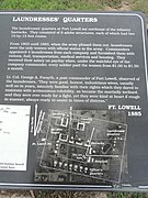
The orientation of the post was set according to magnetic north. It featured a large parade grounds, officers' quarters, quartermaster and commissary storehouses, corrals, quarters for enlisted men as well as for married non-commissioned officers. The most prominent building on post was the hospital, the adobe remnants of which still stand under a protective structure. A lane lined with cottonwood trees, aptly named Cottonwood Lane, graced the area in front of the officers' houses.
After the Army decommissioned the post in 1891, the civilian occupied military reservation land was sold and private farms were reestablished along the Rillito River. Mexican families from Sonora soon moved north to take advantage of the "free" repurposed fort housing and framing jobs. In the early 20th century the small village continued to grow west of the ruins of the old fort. This occupation has become known as the El Fuerte Period.[4]
The small community of adobe houses would continue grow in the first two decades of the 20th century to include the El Callejón Fort Lowell School, and two churches, San Pedro Chapel and the Fort Lowell Union Church. These three civic building created the nexus of the village center and formed an informal plaza.
Fort Lowell Art Colony
In the 1930s Nan, Pete and Charles Bolsius rebuilt the crumbling adobe ruin of the Post Traders Store making it their home and studio. Through the 1940s a number of other artists moved into the Fort Lowell area establishing a burgeoning artist colony. Significant artists and intellectuals built homes and lived in the area including: René Cheruy and Germaine Cheruy, Win Ellis, modernist painter Jack Maul, sculptor and designer Giorgio Belloli, Charles Bode, architectural designer Veronica Hughart, anthropologists Edward H. Spicer and Rosamond Spicer, photographer Hazel Larson Archer and weaver Ruth Brown. The artist colony attracted writers and poets including beat generation Alan Harrington and Jack Kerouac whose visit is documented in his iconic book On the Road.
Notable artists and writers (20th century)
Charles Bolsius, Painter, Prints, Woodwork, Architectural Design
"The Boy Scouts had a long connection to Fort Lowell," explained columnist David Leighton, in the Arizona Daily Star newspaper on February 5, 2017:
The first known visit to the old fort ruins by the Boy Scouts of Tucson, which had been established the year before, occurred in April 1912. The scouts marched out to the abandoned fort under the direction of a member of the University of Arizona's military cadet program. During the week-long encampment the boys did a lot of drilling like soldiers but also were given some free time to search for Native American relics.
A couple years later, the Fort Lowell Boy Scouts troop, which was formed from boys in the neighborhood that had grown up around the old Ft. Lowell ruins, called El Fuerte and a farming community, populated by Mormons, farther west that came to be named Binghamton. The two troops played a baseball game that year and are believed to have used the area fairly regularly for campouts, target practice etc. until about 1921, when Camp Lawton opened on Mount Lemmon. Within a few years, the Boy Scouts of Tucson became part of the Catalina Council of the Boy Scouts of America.
In 1945, with the assistance of prominent local rancher Carlos Ronstadt, the Boy Scouts bid and obtained 40 acres of the old ruins while preventing the land from falling into the hands of developers, who were rumored to have plans of constructing a subdivision where the ruins existed.
A water system was put in place by the Boy Scouts and volunteers and three structures were acquired and donated to the site. One of the structures was used as the Ft. Lowell Training Center and another structure as the Ranger Station. In 1953, the scouts obtained the funds to have a roof built over the remains of the post hospital that still exists today, constructed a rail fence around the hospital ruins which was later replaced by a chain link fence and put up a flagpole just to the south of the remains.
While many successful scout events took place there, by 1957 it was realized that the Boy Scouts didn't have enough money to maintain the site and sold it to Pima County that year.[5]
The fort lay in ruins for many years and many of its adobe structures went into disrepair. Some of the portions of the fort were sold to the families in Tucson. Among the families which acquired in 1928, large portions where the fort was situated was the Adkins family. The Adkins family established a steel tank manufacturing business on the site. In 2006, Jim Campbell, a local developer, purchased the property (known as the Adkins Parcel) and then traded the property to the City of Tucson. The City and County had been attempting to purchase the Adkins Parcel for over 30 years. In 2009, the city in association with Pima County created a Master Plan for the creation and development of what was to become the Fort Lowell Park.[7] The park features ball fields, tennis and racquetball courts, a large public swimming pool, and the Fort Lowell Museum dedicated to Fort Lowell's days as an active military installation. Fort Lowell also includes a large pond.
The Adkins Parcel that Tucson purchased from Jim Campbell lies immediately west of Craycroft Road where the last of the original officers' quarters stand. Plans indicated that they would be open to the public as a museum. However, high levels of lead paint were found and the buildings were not opened. On the north end of the former Adkins parcel stands a pile of large stones that, according to local lore, formed a wall of the guardhouse in which Geronimo was kept prior to his removal from Arizona.
The Fort Lowell Museum is located in the reconstructed Commanding Officer's quarters and is run by the Tucson Presidio Trust which also runs the Presidio San Agustín del Tucsón. Exhibits focus on military life on the Arizona frontier. The Fort Lowell Historic District is the neighborhood located on or near Fort Lowell. It is set aside as a historic district.
A reconstructed Fort Lowell was featured in the 1972 film Ulzana's Raid, starring Burt Lancaster. However, the reconstructed fort was actually built in an area just southwest of the Santa Rita Mountains, near Nogales, Arizona.
National Register of Historic Places
Fort Lowell Park and the ruins within the property were listed in the National Register of Historic Places on December 13, 1978. Other properties, which belong to the park or which in the past belonged to Fort Lowell, are individually listed in National Register of Historic Places and include
Charles Bolsius House, listed December 13, 1978, a 20th-century house built around one of the fort's original storehouses
San Pedro Chapel (St. Peter's at Fort Lowell Mission) listed April 28, 1993
City of Tucson Fort Lowell Historic Preservation Zone
Inclusive and more expansive of the buildings listed National Register of Historic Places, the City of Tucson established the Fort Lowell Historic Zone as a zoning overlay in 1981 to preserve the cultural and historical integrity of the Fort Lowell area. The zoning overlay provides protections for historically significant buildings, ruins, and landscapes, preventing inappropriate alterations and encouraging preservation efforts. The Fort Lowell Historic Zone Advisory Board, composed of local stakeholders and preservationists, oversees the area, reviewing changes to properties within the zone to maintain historical accuracy. The zone includes numerous other building and cultural assets including vernacular Sonoran adobe architecture and homes designed by Charles Bolsius, and Veronica Hughart. Some of the houses and buildings include:
Historic buildings not included in the national register or city historic zone
Several important historic buildings within the Fort Lowell area were not included in either the National Register of Historic Places or the City of Tucson Fort Lowell Historic Zone due to the timing of the original designations, which occurred decades ago. Since those designations, additional structures have been identified as having historical, architectural, or cultural significance, but they remain outside the official protections because the review processes at the time did not encompass more recent historical developments.
The omission of these buildings highlights the evolving nature of historic preservation and underscores the need for ongoing efforts to update and expand protective designations as new historic contexts emerge. While these buildings are not currently protected by the same regulations as those within the official zones, many continue to play a key role in maintaining the neighborhood's historical ambiance and cultural significance.
Schilling, Frank A. (June 1960). "Military Posts of the Old Frontier: Arizona – New Mexico". The Historical Society of Southern California Quarterly. 42 (2). University of California Press: 133–149. doi:10.2307/41169446. JSTOR41169446.
This page is based on this Wikipedia article Text is available under the CC BY-SA 4.0 license; additional terms may apply. Images, videos and audio are available under their respective licenses.

 Entrance to Fort Lowell Park
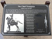
 Statue of cavalry soldier at Fort Lowell Park.
 Ruins of the post hospital.
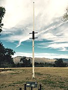 The third reconstructed flagstaff in Fort Lowell
 The adobe ruins of one of two soldier barracks
 The Fort Lowell Museum.
 The Quartermaster's Quarters
 The Fort Lowell Post Traders Store and "Riallito House" located at 5425 E. Fort Lowell Rd.
 The Fort Lowell Quartermaster's Storehouse located at 5479 E. Fort Lowell Rd.
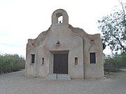 The San Pedro Chapel, also known as the San Pedro de Fort Lowell (St. Peter's at Fort Lowell Mission).