Brief history
According archeologists the specimens of pottery and stone implements found in the area of Greenlee County, where the town of Duncan is located indicate that the members of the Anasazi were among the first people to inhabit the region. This was hundreds of years before the first white men, the Spanish explorers arrival. The Anasazi are considered by historians to have been an advanced ancient native-American civilization. Eventually the Apaches, who were hunters, gatherers, and raiders, would become the dominant native-American force. [1] [2] [3] [4]
New Spain
Francisco Vasquez de Coronado was a governor of a province in New Spain (in Mexico). He heard reports of the legend of the Seven Golden Cities and believed they were located north of Mexico's western coast. Vasquez de Coronado organized an expedition which eventually passed through the area where the San Francisco River is located. He failed in his mission. [5] [4] [1] [2] [3] Fray Marcos de Niza, who was a notable Spanish missionary, also passed through the area with the intention of converting the natives to Catholicism. [6]
New Mexico
The territory that includes present-day New Mexico and Arizona was designated as "New Mexico”. Mexico became independent from Spain in 1821. A team of mountain men and trappers that were led by James Ohio Pattie in 1824 and 1825 arrived, and they searched the San Francisco River edges for beavers in the area. Hats made from the fur of beavers were very popular in the 1800s. [1] [2] [4] [7] [8]
In 1845, Mexico severed its relations with the United States because of the annexation of Texas by the United States. United States President James K. Polk declared war against Mexico in what became known as the Mexican–American War. The Mormon Battalion was among the troops which entered the area. Arizona north of the Gila River was taken by the United States under the terms of the Treaty of Guadalupe Hidalgo at the end of the war. [9] [2] [4] [8]
Arizona Territory
The California volunteers pursuing the Apaches in 185, discovered the first minerals in the Greenlee area. Conflicts between the Apaches and the advancing Anglo settlers resulted in a war known as the Apache Wars. The conflict with the Apaches lasted 26 years. Mining for gold and silver began in 1864, followed by copper in 1872. [1] [2] [10] [4] [8]
Duncan had its origin on the north bank of the San Francisco River where two men, whose surname was Purdy, established a way station on the ore haulage line that ran between Clifton and Silver City, New Mexico. In 1883, a post office was established in Purdy. Thus the new settlement was named Purdy. Scottish investors financed the building of a narrow gauge railway from Clifton to Lordsburg, New Mexico. The railway line was called the Arizona and New Mexico Railroad, and it passed through Purdy. James Duncan Smith became the managing director of the Arizona Copper Company, and, after Purdy was moved to the south bank of the river, it was renamed Duncan. The Purdy post office was relocated to the new location of Purdy and thus the settlement was renamed Duncan. Duncan was officially founded in 1883 and became a shipping point for markets in the middle west and east. Zinc and copper mines were established in the hills around Duncan. The railroad stop in Duncan made the town a marketing center for farm produce and a shipping point for ore and cattle. Greenlee County was created in 1909 and named for Mason Greenlee, who was an early settler in the Clifton area. [11] [7] [8] [12]
Duncan Pride Society
The Duncan Pride Society was established on March 8, 2001. The society's vision statement is the following: "PRIDE is committed to work with our town government, community leaders and all area residents to preserve and enhance our town's overall image and historic value". The society's first project was Spezia Square, placed on a historical corner located on the Old West Highway. Among the society's accomplishments is the clean-ups and painting of scenes on most of the old buildings. [13]
Jim McPherson, Arizona Preservation Foundation board president, has stated the following:
It is crucial that residents, private interests, and government officials act now to save these elements of our cultural heritage before it is too late. [14]
An individual structure listed in the National Register of Historic Places (NRHP) is the Benjamin F. Billingsley House listed on August 25, 1983, reference: #83002998. The following is in accordance to the NRHP: Applicable Criteria: Architecture/Engineering Person; Architectural Styles: Queen Anne; Areas Of Significance: Commerce, Architecture; Periods Of Significance: 1900–1924 [15] Sandra Day O’Connor, the first female justice of the United States Supreme Court, grew up on the Lazy B, a cattle ranch near Duncan. [16]
This page is based on this
Wikipedia article Text is available under the
CC BY-SA 4.0 license; additional terms may apply.
Images, videos and audio are available under their respective licenses.


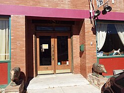
 Benjamin F. Billingsley House - 1900
 Simpson Hotel (former Hotel Hobbs) - 1914
 Freiheit Building - 1913
 Country Store - 1909
 Duncan Restaurant - 1909
 Duncan Theater - 1921
 River Front Lounge (former Bonnie Heather Bar/Pool Hall) - 1925
 Bonnie Heather Inn - 1920
 First Duncan School Building - 1908
 Old Duncan Bus Station now Hotel Duncan - 1920
 Lonesome Dove Mercantile - 1860
 Saint Mary's Catholic Church - 1936
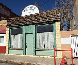 Bank of Duncan - 1908
 Duncan Opera House - 1920
 S & L Enterprises - 1896
 Bart Tipton's Saloon - 1905
 Greenlee County Building - 1890
 House on 211 Railroad Ave. - 1920
 Germaine store - 1900
 Knights of Pythias lodge #27 - 1900
 Duncan Church of Christ - 1914
 Duncan Stage Stop - 1890
 Antique town clock
 1950 Chevrolet 6400 2 ton fire truck