El Mirage is a city in Maricopa County, Arizona, United States. As of the 2020 census, the population of the city was 35,805,[3] up from 31,797 in 2010.
The Hohokam Native American tribe were the earliest inhabitants of the area that is now El Mirage. The ingenious Hohokam developed an elaborate irrigation network using only stone instruments and organized labor. They were commonly known as the "Canal Builders".
During the early 1930s, migrant farm workers settled in El Mirage on the west bank of the Agua Fria River. Mexican migrants came to El Mirage to help build the canals and harvest the first crops.[4] Farming and agriculture remain central to El Mirage's economy, but it has witnessed a robust industrial growth over the past few decades, emerging as a diverse urban community.
In 1977, the city annexed 2,000 acres of land for a proposed planned community with apartments, shopping centers, and industrial development. Immediately following this announcement Attorney General Bruce Babbitt, sued in an attempt to undo this annexation due to its proximity to Luke Air Force Base. The lawsuit failed, but prompted the cities of Glendale and Goodyear to work together to buy land surrounding the base to stop any further annexations.
In the early eighties, El Mirage announced its plans for economic redevelopment. The city planned to build more housing but the centerpiece of the plan was a $20 million resort and convention center, along with a golf course. A spring training baseball stadium, medical center, and auto mall were also pitched for the area. The proposed redevelopment sat, however, only five miles north from the Air Force base's runway. Once again officials from Luke Air Force Base and other government officials began to raise concerns and turn public opinion against the project. City officials travelled to Washington D.C. to fight the land use disputes, arguing that the base had known about the land acquisitions leading to the redevelopment plans and could have raised concerns before it spent the money purchasing land and making deals with companies. Ultimately, nothing would be built on the land largely due to the concerns from Luke AFB.[5] As a result of all of this, in 2009 when Luke Air Force Base was bidding to get the new F-35 fighter jets, El Mirage was an outlier among local cities. While many cities stood behind the Air Force base's bid wanting to keep the base operational, El Mirage voiced its opinion against the facility. The city believed that the base had hurt its financial potential and would continue doing so.[6]
The city became an incorporated town on June 25, 1951. The city held a special election to become a city in 1983, and has continued to grow since.[7][8]
According to the United States Census Bureau, the city has a total area of 9.95 square miles (25.8km2), of which 0.06 square miles (0.16km2), or 0.56%, are water.[1]
Climate
Climate data for Youngtown, Arizona, 1991–2020 normals, extremes 1964–present
At the 2000 census, there were 7,609 people in 2,121 households, including 1,737 families, in the city. The population density was 786.8 inhabitants per square mile (303.8/km2). There were 3,162 housing units at an average density of 326.9 per square mile (126.2/km2). The racial makeup of the city was 66.3% White, 3.3% Black or African American, 0.9% Native American, 0.4% Asian, 0.1% Pacific Islander, 26.2% from other races, and 3.0% from two or more races. 66.8% of the population were Hispanic or Latino of any race.
Of the 2,121 households 48.8% had children under the age of 18 living with them, 55.3% were married couples living together, 17.7% had a female householder with no husband present, and 18.1% were non-families. 13.0% of households were one person and 3.7% were one person aged 65 or older. The average household size was 3.59 and the average family size was 3.87.
The age distribution was 36.8% under the age of 18, 14.1% from 18 to 24, 28.6% from 25 to 44, 13.8% from 45 to 64, and 6.6% 65 or older. The median age was 25 years. For every 100 females, there were 105.5 males. For every 100 females age 18 and over, there were 105.0 males.
The median household income was $33,813 and the median family income was $33,468. Males had a median income of $25,176 versus $19,192 for females. The per capita income for the city was $10,342. About 12.6% of families and 15.9% of the population were below the poverty line, including 14.2% of those under age 18 and 22.0% of those age 65 or over.
El Mirage is near Luke U.S. Air Force Base, the largest Fighter Pilot Training Base in the North Atlantic Treaty Organization (NATO).
Sundown Mountain - opened 2004, alternative school for only 11th and 12th grades
Valley Vista High School - opened 2006, although not located in El Mirage, El Mirage residents north of Waddell Rd./Thunderbird Rd. are zoned for Valley Vista.
El Mirage also has various private schools. Desert Choice School, a school design specifically for special education, Sun Valley Christian School, and Valley Learning Center, a pre-school and daycare.[14]
Historic structures of El Mirage
Front of the former city hall building.
Historic El Mirage Agua Fria River Bridge built in 1895.
Former El Mirage City Hall located at 12145 NW Grand Ave.
El Mirage Motel. These are the individual rooms of the motel which were used by motorist who traveled through Grand Ave.
El Mirage Motel was built out of fieldstone in 1937 and is located at 12229 NW Grand Ave. The property has now been demolished.
This page is based on this Wikipedia article Text is available under the CC BY-SA 4.0 license; additional terms may apply. Images, videos and audio are available under their respective licenses.
 Front of the former city hall building.
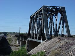 Historic El Mirage Agua Fria River Bridge built in 1895.
 Former El Mirage City Hall located at 12145 NW Grand Ave.
 El Mirage Motel. These are the individual rooms of the motel which were used by motorist who traveled through Grand Ave.
 El Mirage Motel was built out of fieldstone in 1937 and is located at 12229 NW Grand Ave. The property has now been demolished.