Apache Junction, Arizona

Last updated

Apache Junction, Arizona
Apache Junction-welcome to Apache Junction-1.JPG
Welcome marker
Apache Junction, Arizona official flag.png
Apache junction seal.png
Apache Junction, Arizona official logo.png
Motto: 
"Surrounded by Legends"
Maricopa County and Pinal County Arizona Incorporated and Unincorporated areas Apache Junction Highlighted 0402830.svg
Location in Pinal and Maricopa counties, Arizona
USA Arizona location map.svg
Red pog.svg
Apache Junction
Usa edcp location map.svg
Red pog.svg
Apache Junction
Coordinates: 33°23′55″N111°32′06″W / 33.39861°N 111.53500°W / 33.39861; -111.53500
CountryUnited States
State Arizona
Counties
Incorporated November 24, 1978 (1978-11-24)
Government
  Type Council–manager [1]
  MayorChip Wilson
Area
[2]
  Total35.08 sq mi (90.86 km2)
  Land35.07 sq mi (90.83 km2)
  Water0.01 sq mi (0.03 km2)
Elevation
[3]
1,700 ft (500 m)
Population
 (2020) [4]
  Total38,499
  Density1,097.81/sq mi (423.86/km2)
Time zone UTC-7 (MST (no daylight saving time))
ZIP codes
85119–85120
Area code 480
FIPS code 04-02830
GNIS feature ID2409718 [3]
Website www.ajcity.net

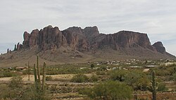
Apache Junction (Western Apache: Hagosgeed) is a city in Pinal and Maricopa County, Arizona, United States. As of the 2020 census, the population was 38,499, [4] most of whom lived in Pinal County. It is named for the junction of the Apache Trail and Old West Highway. The area where Apache Junction is located used to be known as Youngberg. Superstition Mountain, the westernmost peak of the Superstition Mountains, is to the east.

Contents

History

The location became a historical landmark. It is part of a scenic byway that was opened to the public in 1922 and is currently part of a 120-mile-long (190 km) "circle trail" that begins and ends in Apache Junction. [5] The O'odham Jeweḍ, Akimel O'odham (Upper Pima), and Hohokam people all have tribal ties to the area. [6]

Geography

Apache Junction is in northern Pinal County at 33°24′54″N111°32′46″W / 33.415035°N 111.546025°W / 33.415035; -111.546025 . [7] A small portion of the city limits comprising the El Dorado Mobile Estates Resort and Senior Cottages of Apache Junction extends west into Maricopa County. The city is bordered to the west partly by the city of Mesa and to the southeast by unincorporated Gold Canyon. Downtown Phoenix is 33 miles (53 km) to the west via U.S. Route 60, which also leads east 54 miles (87 km) to Globe. Arizona State Route 88, following the route of the old Apache Trail, leads northeast from Apache Junction through the Superstition Mountains 45 miles (72 km) to State Route 188 at Theodore Roosevelt Lake.

Apache Junction is located in the east part of the Phoenix-Mesa-Chandler Metropolitan Area.

According to the United States Census Bureau, the city has an area of 35.1 square miles (91 km2), of which 0.01 square miles (0.03 km2), or 0.03%, were listed as water. [2]

The town is bounded to the east by the Superstition Mountains (a federal wilderness area and home of the Lost Dutchman's Gold Mine) and to the north by the Goldfield Mountains with the Bulldog Recreation Area. Goldfield Ghost Town, a tourist location preserved from former prospecting days, lies near the western face of Superstition Mountain just off Highway 88 (Apache Trail). It is located just southwest of the site of the ghost town of Goldfield. [8]

In October 2021, Apache Junction annexed ten square miles south of the city's previous southern boundary. [9]

Climate

According to the Köppen Climate Classification system, Apache Junction has a hot semi-arid climate, abbreviated "BSh" on climate maps. The hottest temperature recorded in Apache Junction was 119 °F (48.3 °C) on June 26, 1990, and July 2728, 1995, while the coldest temperature recorded was 17 °F (−8.3 °C) on January 14, 2007. [10]

Climate data for Apache Junction, Arizona, 1991–2020 normals, extremes 1987–present
MonthJanFebMarAprMayJunJulAugSepOctNovDecYear
Record high °F (°C)83
(28)
88
(31)
98
(37)
103
(39)
111
(44)
119
(48)
119
(48)
115
(46)
113
(45)
105
(41)
95
(35)
82
(28)
119
(48)
Mean maximum °F (°C)75.6
(24.2)
80.2
(26.8)
88.1
(31.2)
96.5
(35.8)
103.6
(39.8)
111.0
(43.9)
112.1
(44.5)
110.8
(43.8)
106.8
(41.6)
99.6
(37.6)
87.0
(30.6)
76.2
(24.6)
113.5
(45.3)
Mean daily maximum °F (°C)66.7
(19.3)
70.1
(21.2)
77.1
(25.1)
84.7
(29.3)
93.4
(34.1)
103.0
(39.4)
105.2
(40.7)
103.8
(39.9)
99.2
(37.3)
88.4
(31.3)
75.6
(24.2)
65.6
(18.7)
86.1
(30.0)
Daily mean °F (°C)54.7
(12.6)
57.0
(13.9)
62.4
(16.9)
68.6
(20.3)
76.9
(24.9)
86.0
(30.0)
91.1
(32.8)
90.1
(32.3)
85.2
(29.6)
74.2
(23.4)
62.7
(17.1)
53.9
(12.2)
71.9
(22.2)
Mean daily minimum °F (°C)42.8
(6.0)
43.9
(6.6)
47.6
(8.7)
52.6
(11.4)
60.4
(15.8)
69.1
(20.6)
77.0
(25.0)
76.4
(24.7)
71.2
(21.8)
60.1
(15.6)
49.8
(9.9)
42.2
(5.7)
57.8
(14.3)
Mean minimum °F (°C)29.8
(−1.2)
31.0
(−0.6)
35.4
(1.9)
40.2
(4.6)
48.6
(9.2)
58.0
(14.4)
67.7
(19.8)
68.0
(20.0)
59.4
(15.2)
45.7
(7.6)
34.0
(1.1)
28.6
(−1.9)
26.0
(−3.3)
Record low °F (°C)17
(−8)
20
(−7)
27
(−3)
33
(1)
40
(4)
48
(9)
60
(16)
64
(18)
51
(11)
32
(0)
22
(−6)
22
(−6)
17
(−8)
Average precipitation inches (mm)1.54
(39)
1.65
(42)
1.33
(34)
0.52
(13)
0.26
(6.6)
0.05
(1.3)
1.37
(35)
1.50
(38)
1.07
(27)
0.71
(18)
1.01
(26)
1.54
(39)
12.55
(318.9)
Average precipitation days (≥ 0.01 in)4.54.73.61.91.70.84.35.63.52.72.94.240.4
Source 1: NOAA [11]
Source 2: National Weather Service [10]

Demographics

Historical population
CensusPop.Note
1970 2,390
1980 9,935315.7%
1990 18,10082.2%
2000 31,81475.8%
2010 35,84012.7%
2020 38,4997.4%
2022 (est.)40,1734.3%
U.S. Decennial Census [12]

Apache Junction first appeared on the 1970 U.S. Census as an unincorporated village. It was formally incorporated as a city in 1978.

As of the census of 2010, there were 35,840 people, 15,574 households, and 9,372 families residing in the city. The population density was 929.3 inhabitants per square mile (358.8/km2). There were 22,771 housing units at an average density of 665.1 per square mile (256.8/km2). The racial makeup of the city was 89.5% White, 1.2% Black or African American, 1.1% Native American, 0.8% Asian, 0.1% Pacific Islander, 4.9% from other races, and 2.4% from two or more races. Hispanic or Latino of any race were 14.4% of the population.

There were 15,574 households, out of which 19.6% had children under the age of 18 living with them, 44.6% were married couples living together, 10.7% had a female householder with no husband present, and 39.8% were non-families. 31.4% of all households were made up of individuals, and 15.8% had someone living alone who was 65 years of age or older. The average household size was 2.28 and the average family size was 2.85.

In the city, the population had 19.9% under the age of 20, 4.5% from 20 to 24, 20.4% from 25 to 44, 27.1% from 45 to 64, and 26.2% who were 65 years of age or older. The median age was 47.5 years.

The median income (as of the 2000 census) for a household in the city was $33,170, and the median income for a family was $37,726. Males had a median income of $31,283 versus $22,836 for females. The per capita income for the city was $16,806. About 7.3% of families and 11.6% of the population were below the poverty line, including 18.4% of those under age 18 and 7.4% of those age 65 or over.

Government

Apache Junction was incorporated as a city on November 24, 1978. The city is governed by a collection of elected officials, clerk, and nine boards and commissions. The city council has seven members, which includes the mayor and vice-mayor. The mayor serves a two-year term. [13] The current mayor is Chip Wilson, Vice Mayor Christa Rizzi. [14]

Historic structures

This gallery includes images of some of the remaining historical structures located in Apache Junction. Among the exhibits on the grounds of the Superstition Mountain Museum are studio sets and other Western paraphernalia that were saved from the Apacheland fire of 1969. Apacheland was a 1,800-acre movie set that opened in 1960. [15] Also located in Apache junction is the ghost town of Goldfield. Goldfield was a mining town established in 1893 next to Superstition Mountain. When the mine vein faulted, the grade of ore dropped and the town eventually became a ghost town. The town and its historic buildings were revived as a tourist attraction. [16]

Transportation

Apache Junction is located along U.S. Route 60.

Apache Junction is not served by local buses. [17] Greyhound Lines serves Apache Junction on its Phoenix-El Paso via Globe route.

See also

Related Research Articles

<span class="mw-page-title-main">Pinal County, Arizona</span> County in Arizona, United States

Pinal County is a county in the central part of the U.S. state of Arizona. According to the 2020 census, the population of the county was 425,264, making it Arizona's third-most populous county. The county seat is Florence. The county was founded in 1875.

<span class="mw-page-title-main">Tuba City, Arizona</span> Town in Coconino County, Arizona

Tuba City is an unincorporated town and census-designated place in Coconino County, Arizona, on the Navajo Nation, United States. It is the second-largest community in Coconino County. The population of the census-designated place (CDP) was 8,611 at the 2010 census.

<span class="mw-page-title-main">Globe, Arizona</span> City in Arizona, United States

Globe is a city in Gila County, Arizona, United States. As of the 2020 census, the population of the city was 7,249. The city is the county seat of Gila County. Globe was founded c. 1875 as a mining camp. Mining, tourism, government and retirees are most important in the present-day Globe economy.

<span class="mw-page-title-main">Swift Trail Junction, Arizona</span> CDP in Graham County, Arizona

Swift Trail Junction is a census-designated place (CDP) in Graham County, Arizona, United States. The population was 2,935 at the 2010 census, up from 2,195 in 2000. It is part of the Safford Micropolitan Statistical Area. It is situated at the junction of U.S. Route 191 and State Route 366. The Swift Trail Parkway is a scenic highway that winds through the Coronado National Forest and provides access to the higher elevations of the Pinaleño Mountains.

<span class="mw-page-title-main">Guadalupe, Arizona</span> Town in Maricopa County, Arizona

Guadalupe is a town in Maricopa County, Arizona, United States and part of the greater Phoenix metropolitan area. The town motto, "where three cultures flourish", recognizes the town's roots in the Yaquis, Mexicans and descendants of the original farmers. Since its founding, Guadalupe has been known as a center of Yaqui culture, and it is home to many religious festivals. Nestled between Phoenix and Tempe, the 2020 census listed the population of the town as 5,322. Guadalupe was founded around 1900 by Yaqui Indians, who fled their homeland in Sonora to avoid oppression by the Mexican government of Porfirio Díaz. The cemetery of Guadalupe was established in 1904, in the original townsite. The cemetery is now officially located in Tempe, due to that city's annexation of the land surrounding the cemetery; however, it is still administered by the Guadalupe Clerk's Office. Guadalupe is primarily a residential area; most residents commute to other parts of the Phoenix area to work.

<span class="mw-page-title-main">Mesa, Arizona</span> City in Arizona, United States

Mesa is a city in Maricopa County, Arizona, United States. It is the third-most populous city in Arizona, after Phoenix and Tucson, the 36th-most populous city in the U.S., and the most populous city that is not a county seat. The city is home to 504,258 people as of 2020. It is the most populous city in the East Valley of the Phoenix metropolitan area. It is bordered by Tempe on the west, the Salt River Pima–Maricopa Indian Community on the north, Chandler and Gilbert on the south along with Queen Creek, and Apache Junction on the east.

<span class="mw-page-title-main">New River, Arizona</span> CDP in Maricopa County, Arizona

New River is an unincorporated community and census-designated place (CDP) in Maricopa County, Arizona, United States. The population was 17,290 as of the 2020 census, up from 14,952 at the 2010 census.

<span class="mw-page-title-main">Holbrook, Arizona</span> City in Navajo County, Arizona, US

Holbrook is a city in Navajo County, Arizona, United States. According to the 2010 census, the population of the city was 5,053. The city is the county seat of Navajo County.

<span class="mw-page-title-main">Three Points, Arizona</span> CDP in Arizona, United States

Three Points is a census-designated place (CDP) in Pima County, Arizona, United States. The population was 5,581 at the 2010 census.

<span class="mw-page-title-main">Maricopa, Arizona</span> City in Arizona, United States

Maricopa is a city in the Gila River Valley in Pinal County, Arizona, United States. With 66,290 residents as of 2022, Maricopa is the largest incorporated municipality in Pinal County.

<span class="mw-page-title-main">Queen Valley, Arizona</span> CPD in Pinal County, Arizona

Queen Valley is a census-designated place (CDP) in north central Pinal County, Arizona, United States. The population was 820 at the 2000 census.

<span class="mw-page-title-main">Patagonia, Arizona</span> Town in Arizona, United States

Patagonia is a town in Santa Cruz County, Arizona, United States. As of the 2010 census it had a population of 913. It developed in the mid-19th century as a trading and supply center for nearby mines and ranches. In the 21st century, it is a tourist destination, retirement community, and arts and crafts center.

<span class="mw-page-title-main">Sonoita, Arizona</span> CDP in Santa Cruz County, Arizona

Sonoita is a census-designated place (CDP) in Santa Cruz County, Arizona, United States. The population was 803 at the 2020 census.

<span class="mw-page-title-main">Tubac, Arizona</span> Community in Santa Cruz County, Arizona

Tubac is a census-designated place (CDP) in Santa Cruz County, Arizona, United States. The population was 1,191 at the 2010 census. The place name "Tubac" is an English borrowing from a Hispanicized form of the O'odham name Cuwak, which translates into English as "place of dark water". When first taken into Spanish speech, it was spelled Tubaca. Finally, over time, the latter "a" was dropped. Tubac is situated on the Santa Cruz River.

<span class="mw-page-title-main">Camp Verde, Arizona</span> Town in Yavapai County, Arizona

Camp Verde is a town in Yavapai County, Arizona, United States. As of the 2010 census, the population of the town is 10,873.

<span class="mw-page-title-main">Caswell, Wisconsin</span> Town in Wisconsin, United States

Caswell is a town in Forest County, Wisconsin, United States. The population was 91 at the 2010 census. The unincorporated communities of Cavour and Laona Junction are located within the town. The ghost town of Bagdad was located in the town.

<span class="mw-page-title-main">Superstition Mountain</span> Landform in Arizona, United States

Superstition Mountain is a prominent mountain and regional landmark located in the Phoenix metropolitan area of Arizona, immediately east of Apache Junction and north of Gold Canyon. It anchors the west end of the Superstition Mountains and is a popular outdoor recreation destination, home to numerous trails for hiking and horseback riding. The legend of the Lost Dutchman's Gold Mine centers around the mountain.

<span class="mw-page-title-main">Gold Canyon, Arizona</span> Census-designated place in Arizona, United States

Gold Canyon is a census-designated place (CDP) and unincorporated community in Pinal County, Arizona, United States. The community is sometimes incorrectly called Gold Camp.

The Goldfield Mountains of Arizona are located adjacent to the Superstition Mountains, between Usery Pass and Canyon Lake (Arizona). In 1893, the southern part of the Goldfield Mountains was a large mining district.

<span class="mw-page-title-main">Silly Mountain (Arizona)</span> Mountain in Arizona, USA

Silly Mountain, also known as "Roadside Benchmark", is a mountain in Arizona, United States, located near the city of Apache Junction. It is part of the Superstition Mountain range. The elevation of the mountain is 2,139 feet (652 m), and the prominence is 358 feet (109 m).

References

  1. "Government – Apache Junction, AZ – Official Website". City of Apache Junction. Retrieved December 18, 2019.
  2. 1 2 "2021 U.S. Gazetteer Files: Arizona". United States Census Bureau. Retrieved May 5, 2022.
  3. 1 2 U.S. Geological Survey Geographic Names Information System: Apache Junction, Arizona
  4. 1 2 "Apache Junction city, Arizona: 2020 DEC Redistricting Data (PL 94-171)". U.S. Census Bureau. Retrieved May 5, 2022.
  5. "Apache Junction History – Apache Junction Public Library" . Retrieved October 5, 2019.
  6. "NativeLand.ca". Native-land.ca – Our home on native land. Retrieved September 24, 2021.
  7. "US Gazetteer files: 2010, 2000, and 1990". United States Census Bureau. February 12, 2011. Retrieved April 23, 2011.
  8. "33.415000,-111.548897 – Map of Cities in 33.415000,-111.548897 – MapQuest".
  9. Dyer, Richard (October 20, 2021). "6,600 acres annexed into Apache Junction". Rose Law Group Reporter. Your Valley. Retrieved October 8, 2022.
  10. 1 2 "NOAA Online Weather Data – NWS Phoenix". National Weather Service. Retrieved March 26, 2023.
  11. "U.S. Climate Normals Quick Access – Station: Apache Junction 5 NE, AZ". National Oceanic and Atmospheric Administration. Retrieved March 26, 2023.
  12. "Census of Population and Housing". Census.gov. Retrieved June 4, 2016.
  13. "Government". Apache Junction, AZ Official Website. City of Apache Junction, Arizona. Retrieved November 14, 2014.
  14. Apache Junction city directory
  15. The Arizona Republic
  16. Goldfield Ghost Town
  17. "Funding sought for twice-daily bus service to Apache Junction". Your Valley. Retrieved November 9, 2021.