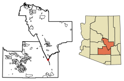
Winkelman is a town in Gila and Pinal counties in Arizona, United States. According to the 2010 census, the population of the town was 353,[2] all of whom lived in Gila County.[3]
According to the United States Census Bureau, the town has a total area of 0.73 square miles (1.9km2), all land.[2] The Gila River passes along the eastern and southern sides of town.
At the 2000 census, 443 people, 160 households, and 112 families lived in the town. The population density was 612.3 inhabitants per square mile (236.4/km2). The 194 housing units had an average density of 268.1 per square mile (103.5/km2). The racial makeup of the town was 62.1% White, 0.2% Black or African American, 36.1% from other races, and 1.6% from two or more races. About 74.7% of the population were Hispanic or Latino of any race.
Of the 160 households, 30.6% had children under 18 living with them, 46.9% were married couples living together, 15.6% had a female householder with no husband present, and 29.4% were not families; 26.3% of households were one person and 11.9% were one person 65 or older. The average household size was 2.77 and the average family size was 3.35.
The age distribution was 29.3% under 18, 9.9% from 18 to 24, 21.2% from 25 to 44, 25.1% from 45 to 64, and 14.4% 65 or older. The median age was 37 years. For every 100 females, there were 95.2 males. For every 100 females age 18 and over, there were 92.0 males.
The median household income was $25,455 and the median family income was $38,250. Males had a median income of $34,583 versus $17,250 for females. The per capita income for the town was $10,506. About 20.0% of families and 27.2% of the population were below the poverty line, including 42.5% of those under age 18 and 16.7% of those age 65 or over.
Schools
Winkelman is home to Winkelman Elementary School and Hayden High School, located adjacent to each other and operated by the Hayden Winkelman Unified School District.
This page is based on this Wikipedia article Text is available under the CC BY-SA 4.0 license; additional terms may apply. Images, videos and audio are available under their respective licenses.
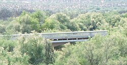
 Winkelman Luten Bridge built in 1916
 Giorsetti’s Grocery -1910