East Verde Estates, Arizona | |
|---|---|
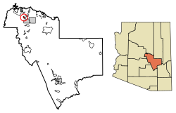 Location of East Verde Estates in Gila County, Arizona. | |
 East Verde Estates  East Verde Estates | |
| Coordinates: 34°17′54″N111°21′52″W / 34.29833°N 111.36444°W | |
| Country | United States |
| State | Arizona |
| County | Gila |
| Area | |
• Total | 2.50 sq mi (6.48 km2) |
| • Land | 2.50 sq mi (6.48 km2) |
| • Water | 0 sq mi (0.00 km2) |
| Elevation | 4,613 ft (1,406 m) |
| Population (2020) | |
• Total | 151 |
| • Density | 60.3/sq mi (23.29/km2) |
| Time zone | UTC-7 (Mountain (MST)) |
| ZIP code | 85541 [2] |
| Area code | 928 |
| GNIS feature ID | 2582778 |
East Verde Estates is a census-designated place in Gila County in the U.S. state of Arizona. East Verde Estates is located approximately six miles north of the town of Payson, off Arizona State Route 87. The population as of the 2010 U.S. census was 170. [3]
