
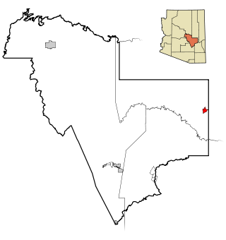
Gila County is in the central part of the U.S. state of Arizona. As of the 2020 census, the population was 53,272. The county seat is Globe.
Canyon Day is a census-designated place (CDP) in Gila County, Arizona, United States, on the Fort Apache Indian Reservation. The population was 1,209 at the 2010 census.

Central Heights-Midland City is an unincorporated community and census-designated place (CDP) in Gila County, Arizona, United States. The area is home to the Pinal Cemetery which serves the community in gereneral but also contains Croatian and Serbian dedicated sections. The Gila County Health and Human Services offices are located within the region. One of the communities few nurseries is located along Golden Hill Road, a notable road in the Central Heights-Midland City area. The population was 2,534 at the 2010 census.

Top-of-the-World is a census-designated place (CDP) in Gila and Pinal counties in the U.S. state of Arizona. The population was 274 at the 2020 census, up from 231 at the 2010 census, and down from 330 at the 2000 census.

Young is an unincorporated community and census-designated place (CDP) in Gila County, Arizona, United States. The population was 588 as of the 2020 census.

Dudleyville is a census-designated place (CDP) in Pinal County, Arizona, United States. The population was 959 at the 2010 census.

Gold Canyon is a census-designated place (CDP) and unincorporated community in Pinal County, Arizona, United States. The community is sometimes incorrectly called Gold Camp.
Roosevelt is a census-designated place (CDP) in Gila County, Arizona, United States. The population was 28 at the 2010 census.

Gila Crossing is a census-designated place (CDP) in Maricopa County, Arizona, United States, within the Gila River Indian Community south of Komatke. The population was 636 at the 2020 census.

Stotonic is a census-designated place (CDP) in Pinal County, Arizona, United States, located in the Gila River Indian Community. The population was 659 at the 2010 census. Stotonic Village has a median household income of $2,499 – the lowest of any CDP in Arizona

Bryce is a census-designated place in Graham County, Arizona, United States. Its population was 173 as of the 2020 census. Bryce is located in the upper Gila River valley, approximately two miles north of Pima and north of the Gila River. The first settlement at Bryce was made in 1883. Bryce is named for settler and shipbuilder Ebenezer Bryce, a Mormon pioneer from Scotland, who is best known as the eponym of Bryce Canyon National Park in Utah.
Freedom Acres is a census-designated place (CDP) in Gila County, Arizona, United States. The population was 90 at the 2020 census, up from 84 at the 2010 census.
Hunter Creek is a census-designated place (CDP) in Gila County, Arizona, United States. The population was 48 at the 2010 census.
Icehouse Canyon is a census-designated place (CDP) in Gila County, Arizona, United States. The population was 677 at the 2010 census.
Mead Ranch is a census-designated place (CDP) in Gila County, Arizona, United States. The population was 38 at the 2010 census.
Mesa del Caballo is a census-designated place (CDP) in Gila County, Arizona, United States. The population was 765 at the 2010 census.
Pinal is a census-designated place (CDP) in Gila County, Arizona, United States. The population was 439 at the 2010 census.
Rock House is a census-designated place (CDP) in Gila County, Arizona, United States. The population was 50 at the 2010 census.
Round Valley is a census-designated place (CDP) in Gila County, Arizona, United States. The population was 487 at the 2010 census.
Wheatfields is a census-designated place (CDP) in Gila County, Arizona, United States. The population was 785 at the 2010 United States Census. It is one of two places in Arizona with this name, the other being a populated place in Apache County.


