Sasco, Arizona

Last updated

Sasco, Arizona
Sasco Power House Arizona Before 1921.jpg
The Sasco Power House with the town in the background
USA Arizona location map.svg
Red pog.svg
Sasco
Location in the state of Arizona
Usa edcp location map.svg
Red pog.svg
Sasco
Sasco (the United States)
Coordinates: 32°32′06″N111°26′22″W / 32.53500°N 111.43944°W / 32.53500; -111.43944
Country United States
State Arizona
County Pinal
Founded1907
Abandonedc.1921
Elevation
[1]
1,837 ft (560 m)
Population
  Total~500
Time zone UTC-7 (MST (no DST))
Post Office openedJuly 10, 1907
Post Office closedSeptember 15, 1919

Sasco is a ghost town located in Pinal County, Arizona, west of Red Rock. Sasco, which is an acronym for the Southern Arizona Smelter Company, was a company town with a large smelter that served several mines. [2] Once an impressive and little-known ghost town, today Sasco is a common sporting destination with shotgun shells, airsoft bb's, paintball splatter, and litter in the area. [3] [4] [5]

Contents

History

Sasco owes its existence to the Development Company of America (DCA), which was headed by Governor Oakes Murphy's brother, Frank M. Murphy. Murphy believed that by consolidating the various mines, railroad, and processing companies in the Silver Bell Mountains into one single organization under his control, mining operations would be much more effective and profitable. Murphy's plan was years ahead of its time, because it called for the creation of one large mine that would employ hundreds of workers over a large area, as opposed to most other mines, which were still operated on a small scale, by only a "handful" of miners at a time. [3] [4]

In 1903, Murphy and his chief engineer, William Field Staunton, purchased the Union Mine and the Mammoth Mine in the Silver Bell Mountains and combined them to form the Imperial Copper Company and the Silver Bell Mine. One year later, DCA built the Arizona Southern Railroad to connect the Silver Bell Mine with the Southern Pacific Railroad at the town of Red Rock. Murphy's next move was to begin work on a large smelter complex and a new town to support it. The resulting Southern Arizona Smelting Company, or Sasco for short, was formed on August 10, 1906. Due to some initial financial problems, work did not begin on the new smelter until the summer of 1907, and it was not completed until February 1908. [3] [6]

When the smelter was finished, work on the town and efforts to attract settlers were undertaken. Soon the town of Sasco was home to a residential neighborhood of 600 people, as well as a few stores and saloons. Mead Goodloe, who oversaw the construction of the smelter, built a large brick home known as "the big house," which became the unofficial town center. A power house was also built to supply electricity to Sasco, the nearby town of Silverbell, and the Silver Bell Mine. In its heyday, the Sasco smelter employed 175 men and by 1910 had already processed 245,000 tons of copper ore. [3] [4] [6]

Although Sasco was set to become "one of the premier smelting towns in the Southwest," its existence was very short. Between 1909 and 1911, problems with the DCA mining operations in the Tombstone area forced Murphy to file for bankruptcy, and the Sasco smelter was closed for the first time. Asarco took over the Silver Bell Mine in 1915 and reopened the Sasco smelter, which temporarily revived the town, but disaster again struck. During the winter of 1918 and 1919, the Spanish flu spread to Sasco and devastated it. Most of the graves in the Sasco Cemetery with plain concrete headstones represent victims of the pandemic. [3]

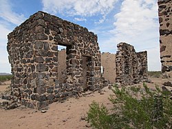
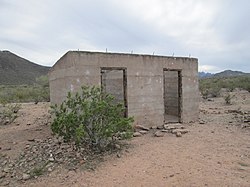
Asarco closed the Silver Bell Mine in 1921 to focus on operations elsewhere, and in late 1933 most of the buildings in Sasco were demolished, along with the railroad that served the town. The remains of several structures can still be visited today, including the Hotel Rockland, the Sasco Jail, and the smelter complex. According to James E. Sherman, in his book Ghost Towns of Arizona, old broken glass and rusty cans can be found all over the area. The Sasco Cemetery is located northeast of the town site, next to the La Osa Ranch house. [3] [4]

See also

Related Research Articles

<span class="mw-page-title-main">Globe, Arizona</span> City in Arizona, United States

Globe is a city in Gila County, Arizona, United States. As of the 2020 census, the population of the city was 7,249. The city is the county seat of Gila County. Globe was founded c. 1875 as a mining camp. Mining, tourism, government and retirees are most important in the present-day Globe economy.

<span class="mw-page-title-main">Dewey–Humboldt, Arizona</span> Town in Yavapai County, Arizona

Dewey–Humboldt is a town in Yavapai County, Arizona, United States. The population of the town was 3,894 according to the 2010 census. The Dewey–Humboldt area was a census-designated place (CDP) at the 2000 census, at which time its population was 6,295.

<span class="mw-page-title-main">ASARCO</span> American integrated energy company

ASARCO is a mining, smelting, and refining company based in Tucson, Arizona, which mines and processes primarily copper. The company has been a subsidiary of Grupo México since 1999.

<span class="mw-page-title-main">Swansea, Arizona</span> Ghost town in La Paz County, Arizona

Swansea is a ghost town in La Paz County in the U.S. state of Arizona. It was settled circa 1909 in what was then the Arizona Territory. It served as a mining town as well as a location for processing and smelting the copper ore taken from the nearby mines.

<span class="mw-page-title-main">Fairbank, Arizona</span> Ghost town in Cochise County, Arizona

Fairbank is a ghost town in Cochise County, Arizona, next to the San Pedro River. First settled in 1881, Fairbank was the closest rail stop to nearby Tombstone, which made it an important location in the development of southeastern Arizona. The town was named for Chicago investor Nathaniel Kellogg Fairbank who partially financed the railroad, and was the founder of the Grand Central Mining Company, which had an interest in the silver mines in Tombstone. Today Fairbank is located within the San Pedro Riparian National Conservation Area.

Grupo México is a Mexican conglomerate that operates through the following divisions: Mining, Transportation, Infrastructure and Fundacion Grupo Mexico.

<span class="mw-page-title-main">Copper Basin Railway</span> Arizona short-line railroad

The Copper Basin Railway is an Arizona short-line railroad that operates from a connection with the Union Pacific Railroad (UP) at Magma to Winkelman, in 54 miles (87 km) of length. The railroad also has a 7-mile (11 km) branch line that runs from Ray Junction to Ray, Arizona. There was formerly an interchange with the San Manuel Arizona Railroad (SMA) at Hayden. The CBRY exists primarily to serve a copper mine. L. S. “Jake” Jacobson was the President and Chief Operating Officer, retiring in 2020 after more than 30 years in his position. In summer 2006, ASARCO Copper Corporation purchased the entire railroad.

<span class="mw-page-title-main">Copper mining in Arizona</span>

In Arizona, copper mining has been a major industry since the 19th century. In 2007, Arizona was the leading copper-producing state in the country, producing 750 thousand metric tons of copper, valued at $5.54 billion. Arizona's copper production was 60% of the total for the United States. Copper mining also produces gold and silver as byproducts. Byproduct molybdenum from copper mining makes Arizona the nation's second-largest producer of that metal. Although copper mineralization was found by the earliest Spanish explorers of Arizona, the territory was remote, and copper could seldom be profitably mined and shipped. Early Spanish, Mexican, and American prospectors searched for gold and silver, and ignored copper. It was not until the completion of the Southern Pacific Railroad in 1876 that copper became broadly economic to mine and ship to market.

The El Paso and Southwestern Railroad began in 1888 as the Arizona and South Eastern Railroad, a short line serving copper mines in southern Arizona. Over the next few decades, it grew into a 1200-mile system that stretched from Tucumcari, New Mexico, southward to El Paso, Texas, and westward to Tucson, Arizona, with several branch lines, including one to Nacozari, Mexico. The railroad was bought by the Southern Pacific Railroad in 1924 and fully merged into its parent company in 1955. The EP&SW was a major link in the transcontinental route of the Golden State Limited.

The Detroit Copper Mining Company was an American copper mining and smelting operation based in Morenci, Arizona. Incorporated in July 1872, it existed as an independent company until 1897, when a controlling interest in the company was purchased by the predecessor of the Phelps Dodge Corporation. It continued to exist as a subsidiary of Phelps Dodge & Co until 1917, when all Phelps Dodge operations in the area were consolidated into the new Phelps Dodge Corporation, Morenci Branch.

<span class="mw-page-title-main">Castle Dome Landing, Arizona</span> Ghost town in Yuma County, Arizona

Castle Dome Landing, Arizona is a ghost town in the Castle Dome Mountains of Yuma County in the U.S. state of Arizona. It was first settled as a transport depot and mining camp around 1863 in what was then the Arizona Territory.

<span class="mw-page-title-main">Helvetia, Arizona</span> Ghost town in Pima County, Arizona

Helvetia is a ghost town in Pima County, Arizona, United States that was settled in 1891 and abandoned in the early 1920s. Helvetia is an ancient name for Switzerland. Today, only the Ray Mine and cemetery are visitable, as the rest of the town has been fenced off due to active mining operations.

<span class="mw-page-title-main">Harshaw, Arizona</span> Ghost town in Arizona, United States

Harshaw is a ghost town in Santa Cruz County in the southeastern part of the U.S. state of Arizona. The town was settled in the 1870s, in what was then Arizona Territory. Founded as a mining community, Harshaw is named after the cattleman-turned-prospector David Tecumseh Harshaw, who first successfully located silver in the area. At the town's peak near the end of the 19th century, Harshaw's mines were among Arizona's highest producers of ore, with the largest mine, the Hermosa, yielding approximately $365,455 in bullion over a four-month period in 1880.

<span class="mw-page-title-main">Congress Mine</span> Inactive gold mine in Yavapai County, Arizona

The Congress Mine is a gold mine located at the ghost town of Congress, Arizona, on the southeastern slope of the Date Creek Mountains, approximately 18 miles north-northeast of Wickenburg, Arizona, at an elevation of about 3,000 feet. The nearest community, four miles away, is modern Congress, formerly known as Congress Jct railroad station or Martinez Post Office. The Congress Mine produced substantial quantities of gold and was considered one of the most productive gold mines in Arizona.

<span class="mw-page-title-main">Twin Buttes, Pima County, Arizona</span> Town

Twin Buttes is a populated place on the east flank of the Sierrita Mountains approximately twenty miles south of Tucson, in Pima County, Arizona, United States. Named after a prominent hill located next to the town, Twin Buttes was founded as a small mining town circa 1903 and abandoned around 1930. Much of the actual town site is now buried underneath mine tailings, and all that remains is the Twin Buttes Cemetery.

<span class="mw-page-title-main">San Xavier, Arizona</span> Populated place in Arizona, United States

San Xavier is a populated place in Pima County, Arizona, United States, situated seventeen miles southwest of Tucson, and six miles northwest of Sahuarita. Originally a small silver mining camp from the 1880s, today San Xavier is little more than a collection of rural homes and partially abandoned mines. The ghost towns of Azurite and Mineral Hill were located about one mile north of San Xavier. Twin Buttes was five miles southeast.

<span class="mw-page-title-main">Silver Bell, Arizona</span> Ghost town in Arizona, United States

Silver Bell is a ghost town in the Silver Bell Mountains in Pima County, Arizona, United States. The name "Silver Bell" refers to a more recent ghost town, which was established in 1954 and abandoned in 1984. The original town, established in 1904, was named "Silverbell" and abandoned in the early 1930s. Both towns were utilized and later abandoned due to the mining of copper in the area.

References

  1. U.S. Geological Survey Geographic Names Information System: Sasco
  2. Heatwole, Thelma (1991) [1951]. "SASCO: Acronym of the Past". Ghost Towns and Historical Haunts in Arizona. Phoenix: American Traveler Press. pp. 131–133. ISBN   978-0914846109.
  3. 1 2 3 4 5 6 "Experience Arizona: Sasco" . Retrieved March 3, 2014.
  4. 1 2 3 4 Sherman, James E.; Barbara H. Sherman (1969). Ghost Towns of Arizona . University of Oklahoma Press. ISBN   0806108436.
  5. "Sasco to Silverbell". HikeArizona.com. Retrieved March 3, 2014.
  6. 1 2 "Silver Bell Complex, Vignettes in Time Exhibit, BLM" . Retrieved March 3, 2014.