There are two communities managed by homeowner associations within the retirement development; SaddleBrooke One, and SaddleBrooke Two, the latter includes the Preserve subdivision. Eagle Crest is a smaller all age subdivision that is part of the SaddleBrooke (CDP).
SaddleBrooke, Arizona is located just north of Oro Valley, AZ. and close to Tucson AZ . The 3400ft elevation in the foothills results in cooler year round temperatures compared to many other Arizona locations. In the foothills of the Catalina Mountains. It has rolling and changing in topography and elevation changes
In 2010 the racial and ethnic makeup of Saddlebrooke's population was 92.8% non-Hispanic white, 0.8% black or African American, 0.2% Native American, 0.9% Asian, 0.9% two or more races and 4.9% Hispanic or Latino.[3]
Gallery
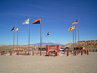
The Preserve subdivision at SaddleBrooke, Arizona
SaddleBrooke Arizona. The Preserve section at SaddleBrooke Two community
McNary is a census-designated place (CDP) in Apache and Navajo counties in the U.S. state of Arizona, on the Fort Apache Indian Reservation. The population was 528 at the 2010 census.
Red Mesa is a census-designated place (CDP) in Apache County, Arizona, United States. The population was 480 at the 2010 census.
St. Michaels is a chapter of the Navajo Nation and a census-designated place (CDP) in Apache County, Arizona, United States. The Navajo Nation Government Campus is located within the chapter at Window Rock.
Teec Nos Pos is a census-designated place (CDP) in Apache County, Arizona, United States. The population was 507 at the 2020 census. It is the western terminus of U.S. Route 64.
Mountainaire is a census-designated place (CDP) in Coconino County, Arizona, United States. The population was 1,119 at the 2010 census.
Tuba City is an unincorporated town and census-designated place in Coconino County, Arizona, on the Navajo Nation, United States. It is the second-largest community in Coconino County. The population of the census-designated place (CDP) was 8,611 at the 2010 census.
New River is an unincorporated community and census-designated place (CDP) in Maricopa County, Arizona, United States. The population was 17,290 as of the 2020 census, up from 14,952 at the 2010 census.
Casas Adobes is an unincorporated community and census-designated place (CDP) located in the northern metropolitan area of Tucson, Arizona. The population was 66,795 at the 2010 census. Casas Adobes is situated south and southwest of the town of Oro Valley, and west of the community of Catalina Foothills.
Catalina is a census-designated place (CDP) in Pima County, Arizona, United States. The population was 7,025 at the 2000 census. Catalina continues to experience increasing population growth, while attempting to maintain its rural character. Catalina remains an unincorporated community, with no plans for annexation into any nearby towns.
Catalina Foothills is an unincorporated community and census-designated place (CDP) located north of Tucson in Pima County, Arizona, United States. Situated in the southern foothills of the Santa Catalina Mountains, Catalina Foothills had a population of 50,796 at the 2010 census. Catalina Foothills is one of the most affluent communities in Arizona and in the U.S., with the 6th highest per capita income in Arizona, and the 14th highest per capita income in the U.S. of communities with a population of at least 50,000. The Catalina Foothills community includes some of Arizona's most expensive homes and land, and has the highest median property value. It also includes resorts, golf courses, and spas.
Flowing Wells is a census-designated place (CDP) in Pima County, Arizona, United States. It is a suburb of Tucson. The population was 16,419 at the 2010 census.
Cordes Lakes is a census-designated place (CDP) in Yavapai County, Arizona, United States. The population was 2,058 at the 2000 census. The Agua Fria National Monument lies to the east and south of the community and Arcosanti is to the north.
North Tustin is an unincorporated community and census designated place (CDP) in Orange County, California. The population was 25,718 at the 2020 census, up from 24,917 in 2010. For statistical purposes, the United States Census Bureau has defined North Tustin as a census-designated place (CDP). It is both the largest CDP and largest unincorporated community in Orange County. The CDP's name was changed from Tustin Foothills in 2005. Located outside the city limits of Tustin, North Tustin has 92705 and 92780 ZIP Codes.
Verde Village is a census-designated place (CDP) in Yavapai County, Arizona, United States. The population was 11,605 at the 2010 census. It is a retirement and bedroom community for Cottonwood.
Anthem is a planned community partially located within Phoenix and partially located within New River, a census-designated place. The community is entirely located in Maricopa County, Arizona, United States, within the Phoenix Metropolitan Area. As of the 2020 census, the population of the Anthem was 23,190.
Meadview is an unincorporated community and census-designated place (CDP) in Mohave County, Arizona, United States, located near Lake Mead. As of the 2020 census, Meadview had 1,420 residents, up from 1,224 as of 2010. It was founded in the 1960s as a retirement community and is still largely one, as well as a vacation spot for people coming to enjoy Lake Mead.
Komatke is a census-designated place in Maricopa County, Arizona, United States. The area currently comprising the census-designated place had a population of 1,013 at the 2020 census, up from 821 at the 2010 census. It is located within the Gila River Indian Community. Its name refers to the Sierra Estrella mountain range, which rises just to the southwest of Komatke.
Theba is an unincorporated community and census-designated place (CDP) in Maricopa County, Arizona, United States. Its elevation is 728 feet (222 m). Theba is located along Interstate 8 and is served by Exit 106. As of the 2020 census, it had a population of 111, down from 158 in 2010.
Avenue B and C or B&C Colonia is a census-designated place (CDP) and colonia in Yuma County, Arizona, United States. The population was 4,176 at the 2010 census. Areas that are part of Avenue B and C were first subdivided in the 1920s and 1930s. The colonia received a sewer system in 2011. It is the fifth most populous community in Yuma County and second most populous CDP.
Martinez Lake is a census-designated place (CDP) in Yuma County, Arizona, United States, located on Martinez Lake. The population was 798 at the 2010 census. It was founded in 1958 as a fishing community. It remains primarily a vacation community.
This page is based on this Wikipedia article Text is available under the CC BY-SA 4.0 license; additional terms may apply. Images, videos and audio are available under their respective licenses.