Dudleyville, Arizona

Last updated

Dudleyville, Arizona
CDP
Pinal County Arizona Incorporated and Unincorporated areas Dudleyville highlighted.svg
Location in Pinal County and the state of Arizona
Usa edcp location map.svg
Red pog.svg
Dudleyville, Arizona
Location in the United States
Coordinates: 32°55′47″N110°44′2″W / 32.92972°N 110.73389°W / 32.92972; -110.73389
Country United States
State Arizona
County Pinal
Area
[1]
  Total6.71 sq mi (17.37 km2)
  Land6.71 sq mi (17.37 km2)
  Water0.00 sq mi (0.00 km2)
Elevation
1,946 ft (593 m)
Population
 (2020)
  Total597
  Density89.00/sq mi (34.36/km2)
Time zone UTC-7 (MST (no DST))
ZIP code
85192 [2]
Area code 520
FIPS code 04-20680
GNIS feature ID 24402

Dudleyville is a census-designated place (CDP) in Pinal County, Arizona, United States. The population was 959 at the 2010 census.

Contents

Geography

Dudleyville is located at 32°55′47″N110°44′2″W / 32.92972°N 110.73389°W / 32.92972; -110.73389 (32.929812, -110.733899). [3]

According to the United States Census Bureau, the CDP has a total area of 6.9 square miles (18 km2), all land.

The village includes the San Pedro River Preserve and the Dudleyville Volunteer Fire District.

Dudleyville was the site of the 2017 Roach Fire, which consumed nearly 1,200 acres.

History

During the 1870s ranchers moved cattle into the lands along the lower San Pedro River. At what would become Dudleyville, a stage station opened in the late 1870s along the Globe to Tucson stage road. On May 8, 1881, William Dudley Harrington, operator of the stage station, was appointed first post master of the new post office of Dudleyville. Harrington and his wife Amanda Jane Crowley were from Missouri and had moved to California before settling with their family on a farm along the San Pedro. The small village of Dudleyville, with stage stop, mercantile and post office, farms, ranches, and prospectors, was a small regional center for two and a half decades. The village was eclipsed by the new town site of Winkleman, a mile north near the mouth of the San Pedro River on the Gila River, with the opening of the Phoenix & Eastern Railroad on September 28, 1904, to the new rail town. [4] [5] [6]

Demographics

Historical population
CensusPop.Note
2020 597
U.S. Decennial Census [7]

As of the census [8] of 2000, there were 1,323 people, 454 households, and 345 families residing in the CDP. The population density was 192.3 inhabitants per square mile (74.2/km2). There were 572 housing units at an average density of 83.1 per square mile (32.1/km2). The racial makeup of the CDP was 62.0% White, 0.1% Black or African American, 2.1% Native American, 0.1% Asian, 0.3% Pacific Islander, 32.7% from other races, and 2.7% from two or more races. 59.0% of the population were Hispanic or Latino of any race.

There were 454 households, out of which 36.6% had children under the age of 18 living with them, 56.4% were married couples living together, 12.3% had a female householder with no husband present, and 23.8% were non-families. 20.0% of all households were made up of individuals, and 7.7% had someone living alone who was 65 years of age or older. The average household size was 2.91 and the average family size was 3.35.

In the CDP, the population was spread out, with 32.8% under the age of 18, 7.4% from 18 to 24, 25.5% from 25 to 44, 22.7% from 45 to 64, and 11.6% who were 65 years of age or older. The median age was 33 years. For every 100 females, there were 103.5 males. For every 100 females age 18 and over, there were 101.1 males.

The median income for a household in the CDP was $35,592, and the median income for a family was $37,200. Males had a median income of $31,948 versus $25,800 for females. The per capita income for the CDP was $13,072. About 8.6% of families and 13.6% of the population were below the poverty line, including 22.5% of those under age 18 and 7.9% of those age 65 or over.

Related Research Articles

<span class="mw-page-title-main">St. David, Arizona</span> CDP in Cochise County, Arizona

St. David is a census-designated place (CDP) in Cochise County, Arizona, United States. The population was 1,699 at the 2010 census.

<span class="mw-page-title-main">Whetstone, Arizona</span> CDP in Cochise County, Arizona

Whetstone is a census-designated place (CDP) in Cochise County, Arizona, United States, north of Sierra Vista. The population was 2,617 at the 2010 census.

<span class="mw-page-title-main">Winslow West, Arizona</span> CDP in Coconino County, Arizona

Winslow West is a census-designated place (CDP) in Coconino and Navajo counties in Arizona, United States. The population was 438 at the 2010 census. The entire community is off-reservation trust land belonging to the Hopi Tribe of Arizona. It lies just west of the city of Winslow, and is more than 50 km (31 mi) south of the main Hopi Reservation.

<span class="mw-page-title-main">Canyon Day, Arizona</span> CDP in Gila County, Arizona

Canyon Day is a census-designated place (CDP) in Gila County, Arizona, United States, on the Fort Apache Indian Reservation. The population was 1,209 at the 2010 census.

<span class="mw-page-title-main">Peridot, Arizona</span> CDP in Gila and Graham Counties, Arizona, US

Peridot is an unincorporated community and census-designated place (CDP) in Gila and Graham counties in the U.S. state of Arizona. The population was 1,350 at the 2010 census.

<span class="mw-page-title-main">San Carlos, Arizona</span> CDP in Gila County, Arizona

San Carlos is a census-designated place (CDP) in Gila County, Arizona, United States. The population was 4,038 at the 2010 census, up from 3,716 in 2000.

<span class="mw-page-title-main">Winkelman, Arizona</span> Town in Gila and Pinal Counties, Arizona

Winkelman is a town in Gila and Pinal counties in Arizona, United States. According to the 2010 census, the population of the town was 353, all of whom lived in Gila County.

<span class="mw-page-title-main">First Mesa, Arizona</span> CDP in Navajo County, Arizona

First Mesa is a census-designated place (CDP) in Navajo County, Arizona, United States, on the Hopi Reservation. As of the 2010 census, the CDP population was 1,555, spread among three Hopi villages atop the 5,700-foot mesa: Hano, Sitsomovi, and Waalpi.

<span class="mw-page-title-main">Keams Canyon, Arizona</span> CDP in Navajo County, Arizona

Keams Canyon is a census-designated place (CDP) in Navajo County, Arizona, United States, on the Hopi Reservation. The population was 304 at the 2010 census.

<span class="mw-page-title-main">Kykotsmovi Village, Arizona</span> CDP in Navajo County, Arizona

Kykotsmovi Village, also known as K-Town or New Oraibi is a census-designated place (CDP) in Navajo County, Arizona, United States. It is the seat of tribal government of the Hopi Reservation, a sovereign nation located in northeastern Arizona. The Hopi word is spelled Kiqötsmovi and means "mound of ruined houses". The population was 776 at the 2000 census. The Hopi reservation occupies part of Coconino and Navajo counties, encompasses more than 1.5 million acres, and is made up of 12 villages on three mesas. Kykotsmovi is one of the 12 villages located in third mesa. Third Mesa includes Hotvela (Hotevilla), Paaqavi (Bacavi), Munqapi (Moencopi), Kiqotsmovi (Kykotsmovi), and Orayvi (Oraibi).

<span class="mw-page-title-main">Drexel-Alvernon, Arizona</span> CDP in Pima County, Arizona

Drexel-Alvernon was a census-designated place (CDP) in Pima County, Arizona, United States. The population was 4,192 at the 2000 census.

<span class="mw-page-title-main">East Sahuarita, Arizona</span> Community in Pima County, Arizona

East Sahuarita was a census-designated place (CDP) in Pima County, Arizona, United States. The population was 1,419 at the 2000 census. The CDP comprises the unincorporated neighborhoods east of incorporated Sahuarita.

<span class="mw-page-title-main">Littletown, Arizona</span> CDP in Pima County, Arizona

Littletown was a census-designated place (CDP) in Pima County, Arizona, United States. The population was 1,010 at the 2000 census. The area was annexed into Tucson in 2017.

<span class="mw-page-title-main">Vail, Arizona</span> CDP in Pima County, Arizona

Vail is a census-designated place (CDP) in Pima County, Arizona, United States. It is 24 miles (39 km) southeast of Tucson. The population was 10,208 at the 2010 census, up from 2484 in the 2000 census. The area is known for the nearby Colossal Cave, a large cave system, and the Rincon Mountains District of Saguaro National Park, a top tourism spot within Arizona.

<span class="mw-page-title-main">San Manuel, Arizona</span> CDP in Pinal County, Arizona

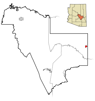
San Manuel is a census-designated place (CDP) in Pinal County, Arizona, United States. The population was 3,551 at the 2010 census.

<span class="mw-page-title-main">Farmington, California</span> Census-designated place in San Joaquin, California

Farmington is a census-designated place (CDP) in San Joaquin County, California. The population was 172 at the 2020 census, down from 207 at the 2010 census.

<span class="mw-page-title-main">Honalo, Hawaii</span> Census-designated place in Hawaii, U.S.

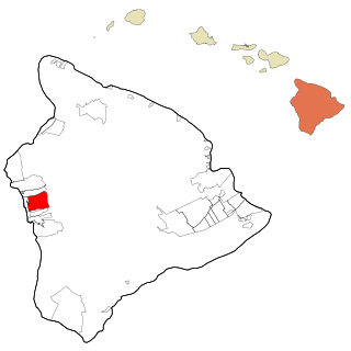
Honalo is a census-designated place (CDP) in Hawaiʻi County, Hawaiʻi, United States. The population was 2,423 at the 2010 census, up from 1,987 at the 2000 census.

<span class="mw-page-title-main">West Havre, Montana</span> Census-designated place in Montana, United States

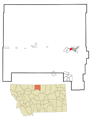
West Havre is a census-designated place (CDP) in Hill County, Montana, United States. The population was 316 at the 2010 census, up from 284 in 2000.

<span class="mw-page-title-main">Oljato–Monument Valley, Utah</span> CDP in Utah, United States

Oljato-Monument Valley is a census-designated place (CDP) in San Juan County, Utah, United States. The population was 864 at the 2000 census.

<span class="mw-page-title-main">Oljato-Monument Valley, Arizona</span> CDP in Navajo County, Arizona

Oljato-Monument Valley is a census-designated place (CDP) in Navajo County, Arizona, United States. The population was 154 at the 2010 census.

References

  1. "2020 U.S. Gazetteer Files". United States Census Bureau. Retrieved October 29, 2021.
  2. "Dudleyville AZ ZIP Code". zipdatamaps.com. 2023. Retrieved May 3, 2023.
  3. "US Gazetteer files: 2010, 2000, and 1990". United States Census Bureau. February 12, 2011. Retrieved April 23, 2011.
  4. Barnes. Arizona Place Names . University of Arizona Press.
  5. Theobald. Arizona Territory Post Offices and Post Masters. Arizona Historical Foundation.
  6. Pinal County Enumeration Sheets. "U S 1880 Census" . Retrieved August 7, 2014.
  7. "Census of Population and Housing". Census.gov. Retrieved June 4, 2016.
  8. "U.S. Census website". United States Census Bureau . Retrieved January 31, 2008.