Silver Bell, Arizona

Last updated

Silver Bell, Arizona
Silver Bell Ruins 2014.jpg
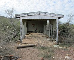
A ruin in Silver Bell.
USA Arizona location map.svg
Red pog.svg
Silver Bell, Arizona
Location in the state of Arizona.
Usa edcp location map.svg
Red pog.svg
Silver Bell, Arizona
Silver Bell, Arizona (the United States)
Coordinates: 32°23′05″N111°29′56″W / 32.38472°N 111.49889°W / 32.38472; -111.49889
Country United States
State Arizona
County Pima
Time zone UTC-7 (MST (no DST))
Post Office openedAugust 18, 1904

Silver Bell is a ghost town in the Silver Bell Mountains in Pima County, Arizona, United States. The name "Silver Bell" refers to a more recent ghost town, which was established in 1954 and abandoned in 1984. The original town, established in 1904, was named "Silverbell" and abandoned in the early 1930s. [1] [2] Both towns were utilized and later abandoned due to the mining of copper in the area.

Contents

According to James E. Sherman's Ghost Towns of Arizona, Silverbell was "one of the most renowned mining camps in the Southwest," and was also described as "the Hell-hole of Arizona." Today nothing remains of the town other than a cemetery. [3]

The later Silver Bell was established when Asarco shifted its attention back to mining in the Silver Bell Mountains in the early 1950s. Located four miles (6.4 km) southeast of the original town site, next to the present-day Silver Bell Mine, the town of Silver Bell was also short-lived, and only a few small ruins remain. [1]

History

Silverbell

The history of mining in the Silver Bell Mountains is fairly convoluted, largely due to the dynamic nature of the copper business in the late nineteenth and early twentieth centuries. According to geologists and researchers, the richest, most densely exploited area occupied a narrow zone along the southwest flank of the range. Although copper was of primary interest, some silver, lead, and gold were also mined. [1]

The first documented prospecting began in the early 1870s, under the leadership of Charles O. Brown, who was from Tucson. By mid 1874, he and his partners had opened the Mammoth Lode, the Young America Mine, and a smelter. Other claims and mines established in the latter quarter of the century included the Atlas, Old Boot, and prospector mines; each was exploited by various short-lived partnerships, companies, and lessees. At this time in the American West, it was common for miners working in proximity to form self-governing "mining districts" in the absence of strong territorial authority. Miners elected a leader and a recorder, and they formed committees to establish district rules and boundaries. In time the term "mining district" developed a less formal, more geographical meaning. In the 1890s, two English companies entered the Silver Bell Mining District: the Silver Bell Mining and Smelting Company, Ltd., and the Tucson Mining and Smelting Company, Ltd. Both had very limited success. [1]

By the turn of the century, it must have become clear that consolidation was the best means of achieving profitability, and a partnership under two businessmen named Zeckendorf and Steinfeld managed to acquire a large group of claims in the district. This partnership held one of the most productive mines, the Old Boot. Another group of claims was developed by the Oxide Copper Company; this company retained another major mine, the Young America. In 1901, there was enough mining activity in the district, and enough of a family presence, that Pima County established a public school. It had seventy-five students that year. Two communities were included in the 1900 census: Peltonville, with eighty inhabitants, and Atlas Camp, with fifty-nine. [1]

In 1903, Zeckendorf and his partners sold approximately sixty claims to the Imperial Copper Company. Formed by William Field Staunton, E. B. Gage, and Frank M. Murphy in May 1903, Imperial proceeded to systematically develop its operations in the district. By September 1904, the Arizona Southern Railroad - a fully owned subsidiary of Imperial - was established, built, and operating between Red Rock and Silverbell. Imperial subsequently built a smelter at Sasco, again via a subsidiary; the Southern Arizona Smelting Company, in late 1907. An electrical power plant was also built to supply power to the Sasco smelter, the town of Sasco, the Silver Bell mines, and the town of Silverbell. [1] [3]

Although Imperial was the foremost mining operation in the Silver Bell Mining District between 1903 and 1911, the Oxhide Copper Company continued operations in the area intermittently until the early 1930s. A third company, the Cleveland-Arizona, organized around 1906. It was succeeded a year later by a company that eventually optioned its claims to Imperial, and ultimately ceased operations in 1919. A lessee continued on until about 1925. [1]

Soon after its inception, Imperial Copper established the "town" of Silverbell over the remains of a mining camp that dated to the 1880s. Reaching a population of 1,000 in 1905, the community included a post office, the offices of Imperial and the railroad, a Wells Fargo station, the Imperial company store, a school, two saloons, a Chinese bakery, a barber, a doctor, a justice of the peace, and a deputy sheriff. By 1907, services expanded to include a company hotel, a cobbler, more barbers, and another bakery; a dairy and a public notary arrived by 1909. E. Glen Baker, the most notable local entrepreneur, also opened a saloon in 1909, and later his ventures encompassed: general merchandise store, a billiard parlor and an auto stage. [1]

The lack of readily available potable water was a constant problem. The high mineral content of the local water made it useless for all but laundry and other cleaning. Even gardening was unsuccessful. Throughout the history of the community, drinking water was imported, first by mule and wagon, and eventually by rail. Water was stored in tanks near the company store, piped twice a day through two taps - one of which was located outside the sheriff's office - and sold to local residents. Sometimes guards were posted at the taps, which were turned on for two hours each morning and evening. Archival sources indicate that men did quit mining and railroad construction jobs and leave the district because they were not able to obtain good drinking water. [1]

Silverbell, c.1910 Silverbell Arizona Circa 1910.jpg
Silverbell, c.1910

In spite of this significant difficulty, growth continued, albeit briefly: the 1910 census lists the population as 1,118 persons in 327 households. At least 247 adult women resided at Silver Bell in 1910, and there were hundreds of children. American, Mexican, O'odham, Chinese, and Japanese individuals were present, though the community was totally segregated. Other occupations not gleaned from business directories but listed in the census report include grocer, butcher, restaurant keeper, boardinghouse keeper, musician, stableman, servant, laundress, teacher, carpenter, teamster, photographer, and prostitute. The company also maintained a hospital and attendant personnel at this time. Additional amenities established around 1910 included two firehouses and a movie house. Strikingly, a 1911 business directory seems to indicate that many of the private businesses soon left, presumably as a result of sudden depopulation tied to the declining fortunes of Imperial. [1]

A bad shaft fire and water difficulties at their Tombstone properties led to bankruptcy and forced Imperial to lease its holdings to Asarco in 1911. Asarco began optioning Imperial claims in 1915, ultimately acquiring all of the company's assets - including the railroad and the smelter at Sasco - by 1919. Under Asarco's early tenure, Silverbell again served as the company headquarters and workers' community. Its population temporarily rebounded to 1,200 in 1920. Although the Sasco smelter closed in 1919, after only about four years of renewed operation, the electrical plant continued to supply power to Silver Bell and the mines. The post office, which had also closed in 1911, was reopened in 1916. [1] [3]

This revival also proved to be brief. After the price of copper dropped in 1920, Asarco shifted its focus to other operations. It ceased mining activity in the Silver Bell District entirely by 1930. During that decade about 500 people lived in Silverbell; by 1931, the population had further declined to about forty-five people, only ten of whom actually lived within the company-owned camp limits. The railroad continued to provide mail, supplies, and limited passenger service until late 1933, when it was dismantled and sold. The Sasco smelter was also demolished at that time, and the post office closed for good in 1934. [1]

Sam McEven

Sam McEven was Silverbell's deputy and the man personally responsible for taming old Silverbell. According to local lore, three men were killed in Silverbell in the three days before McEven's arrival in town. McEven spent the first few months of his time in Silverbell arresting, fining, and jailing "local desperadoes" for carrying concealed weapons. [3]

After a miner named Ramon Castro killed Gracio Manzo, he hid from the law for two weeks in an abandoned mine shaft. As deputy, it was McEven's duty to bring Castro in, but he knew that if he entered the shaft without some sort of protection, he would be an easy target for Castro. He devised a simple but effective shield. Obtaining an ore car, upon which he hung a lamp, McEven pushed the bulletproof barrier ahead of him through the mine shaft until he cornered and captured Castro. [3]

Silver Bell

Asarco fared better than the Silver Bell; the company continued to consolidate all of the major holdings in the district, including those once held by Oxide. In 1952, Asarco began open pit operations in the region, and in 1954 it founded a new town - named Silver Bell - four miles to the southeast of the original town site. [1]

Silver Bell survived in its new form from 1952 through 1984. Mining operations at the Silver Bell Mine eventually ceased in 1984, and the town was disbanded. Copper prices continued to tank, the water and sewerage system in town was beginning to fail, and once-contemporary homes were falling into disrepair. Most of the homes were sold and moved to other locations in and around Tucson. In the late 1980s, there were still a few homes and company structures standing. Nothing but a garage (which was the only one in town, belonging to the General Manager) is all that remains. It is pictured above, listed as a "ruin". [4]

In 1989, Asarco purchased the old BS&K Mine, which is located near the original Silverbell site, about a mile (1.6 km) east of the Silver Bell Cemetery in Ironwood Forest. Today, a few BS&K buildings remain standing, along with a few old mine shafts and some wrecked vehicles. [5]

See also

Related Research Articles

<span class="mw-page-title-main">Dewey–Humboldt, Arizona</span> Town in Yavapai County, Arizona

Dewey–Humboldt is a town in Yavapai County, Arizona, United States. The population of the town was 3,894 according to the 2010 census. The Dewey–Humboldt area was a census-designated place (CDP) at the 2000 census, at which time its population was 6,295.

<span class="mw-page-title-main">Jerome, Arizona</span> Town in Yavapai County, Arizona, US

Jerome is a town in the Black Hills of Yavapai County in the U.S. state of Arizona. Founded in the late 19th century on Cleopatra Hill overlooking the Verde Valley, Jerome is more than 5,000 feet (1,500 m) above sea level. It is about 100 miles (160 km) north of Phoenix along State Route 89A between Sedona and Prescott. Supported in its heyday by rich copper mines, it was home to more than 10,000 people in the 1920s. As of the 2020 census, its population was 464.

<span class="mw-page-title-main">ASARCO</span> American integrated energy company

ASARCO is a mining, smelting, and refining company based in Tucson, Arizona, which mines and processes primarily copper. The company has been a subsidiary of Grupo México since 1999.

<span class="mw-page-title-main">Swansea, Arizona</span> Ghost town in La Paz County, Arizona

Swansea is a ghost town in La Paz County in the U.S. state of Arizona. It was settled circa 1909 in what was then the Arizona Territory. It served as a mining town as well as a location for processing and smelting the copper ore taken from the nearby mines.

<span class="mw-page-title-main">Quincy Mine</span> United States historic place

The Quincy Mine is an extensive set of copper mines located near Hancock, Michigan. The mine was owned by the Quincy Mining Company and operated between 1846 and 1945, although some activities continued through the 1970s. The Quincy Mine was known as "Old Reliable," as the Quincy Mine Company paid a dividend to investors every year from 1868 through 1920. The Quincy Mining Company Historic District is a United States National Historic Landmark District; other Quincy Mine properties nearby, including the Quincy Mining Company Stamp Mills, the Quincy Dredge Number Two, and the Quincy Smelter are also historically significant.

Grupo México is a Mexican conglomerate that operates through the following divisions: Mining, Transportation, Infrastructure and Fundacion Grupo Mexico.

Buchans is a town located in the central part of the island of Newfoundland in the province of Newfoundland and Labrador. It is situated on the northwest shore of Beothuk Lake on the Buchans River.

<span class="mw-page-title-main">Copper mining in Arizona</span>

In Arizona, copper mining has been a major industry since the 19th century. In 2007, Arizona was the leading copper-producing state in the country, producing 750 thousand metric tons of copper, valued at $5.54 billion. Arizona's copper production was 60% of the total for the United States. Copper mining also produces gold and silver as byproducts. Byproduct molybdenum from copper mining makes Arizona the nation's second-largest producer of that metal. Although copper mineralization was found by the earliest Spanish explorers of Arizona, the territory was remote, and copper could seldom be profitably mined and shipped. Early Spanish, Mexican, and American prospectors searched for gold and silver, and ignored copper. It was not until the completion of the Southern Pacific Railroad in 1876 that copper became broadly economic to mine and ship to market.

<span class="mw-page-title-main">Sasco, Arizona</span> Ghost town in Arizona, United States

Sasco is a ghost town located in Pinal County, Arizona, west of Red Rock. Sasco, which is an acronym for the Southern Arizona Smelter Company, was a company town with a large smelter that served several mines. Once an impressive and little-known ghost town, today Sasco is a common sporting destination with shotgun shells, airsoft bb's, paintball splatter, and litter in the area.

<span class="mw-page-title-main">Silver City, Utah</span> Ghost town in Utah, United States

Silver City is a ghost town located at the mouth of Dragon Canyon on the west flank of the East Tintic Mountains in northeast Juab County in central Utah, United States. It was a silver mining town approximately 90 miles (140 km) south-southwest of Salt Lake City. This area was considered part of the Tintic Mining District and also produced bismuth, copper, gold, and lead. Settlement began with the first mining strikes here in 1869. Silver City was inhabited until 1930, after the mines played out. Jesse Knight, known as the "Mormon Wizard" for his ability to find ore easily, decided to build a smelter in Silver City because it had the flattest ground in all of the Tintic Mining District. Silver City had several mines in 1890, but the mines hit water and were abandoned. Now there is little left other than a few holes where mines were, and a number of tailings piles. The Silver City Cemetery, however, survives and is listed on the National Register of Historic Places.

<span class="mw-page-title-main">Hecla Mining</span>


Hecla Mining is a gold, silver, and other precious metals mining company based in Coeur d'Alene, Idaho. Founded in 1891, it is the second-largest mining company that produces silver in the country. This area is known as the Silver Valley (Idaho). In 1983, this entire area was designated as a Superfund site by the Environmental Protection Agency, because of land, water, and air contamination resulting from a century of mostly unregulated silver and gold mining.

<span class="mw-page-title-main">Helvetia, Arizona</span> Ghost town in Pima County, Arizona

Helvetia is a ghost town in Pima County, Arizona, United States that was settled in 1891 and abandoned in the early 1920s. Helvetia is an ancient name for Switzerland. Today, only the Ray Mine and cemetery are visitable, as the rest of the town has been fenced off due to active mining operations.

<span class="mw-page-title-main">Harshaw, Arizona</span> Ghost town in Arizona, United States

Harshaw is a ghost town in Santa Cruz County in the southeastern part of the U.S. state of Arizona. The town was settled in the 1870s, in what was then Arizona Territory. Founded as a mining community, Harshaw is named after the cattleman-turned-prospector David Tecumseh Harshaw, who first successfully located silver in the area. At the town's peak near the end of the 19th century, Harshaw's mines were among Arizona's highest producers of ore, with the largest mine, the Hermosa, yielding approximately $365,455 in bullion over a four-month period in 1880.

<span class="mw-page-title-main">Congress Mine</span> Inactive gold mine in Yavapai County, Arizona

The Congress Mine is a gold mine located at the ghost town of Congress, Arizona, on the southeastern slope of the Date Creek Mountains, approximately 18 miles north-northeast of Wickenburg, Arizona, at an elevation of about 3,000 feet. The nearest community, four miles away, is modern Congress, formerly known as Congress Jct railroad station or Martinez Post Office. The Congress Mine produced substantial quantities of gold and was considered one of the most productive gold mines in Arizona.

<span class="mw-page-title-main">Twin Buttes, Pima County, Arizona</span> Town

Twin Buttes is a populated place on the east flank of the Sierrita Mountains approximately twenty miles south of Tucson, in Pima County, Arizona, United States. Named after a prominent hill located next to the town, Twin Buttes was founded as a small mining town circa 1903 and abandoned around 1930. Much of the actual town site is now buried underneath mine tailings, and all that remains is the Twin Buttes Cemetery.

<span class="mw-page-title-main">San Xavier, Arizona</span> Populated place in Arizona, United States

San Xavier is a populated place in Pima County, Arizona, United States, situated seventeen miles southwest of Tucson, and six miles northwest of Sahuarita. Originally a small silver mining camp from the 1880s, today San Xavier is little more than a collection of rural homes and partially abandoned mines. The ghost towns of Azurite and Mineral Hill were located about one mile north of San Xavier. Twin Buttes was five miles southeast.

<span class="mw-page-title-main">Britannia Mines Concentrator</span> Historic site in British Columbia, Canada

The Britannia Mines Concentrator is a National Historic Site of Canada. The large, inclined gravity mill was built on the northwest side of Mount Sheer to assist the transfer of copper ore through the chemical and mechanical processes of the plant. It is a landmark in Britannia Beach, British Columbia some forty-five kilometers north of Vancouver.

References

  1. 1 2 3 4 5 6 7 8 9 10 11 12 13 "Silver Bell Complex, Vignettes in Time Exhibit, BLM" . Retrieved March 1, 2014.
  2. "Ghost Towns of Arizona" . Retrieved March 1, 2014.
  3. 1 2 3 4 5 Sherman, James E.; Barbara H. Sherman (1969). Ghost Towns of Arizona. University of Oklahoma Press. ISBN   0-8061-0843-6.
  4. "Canyon Country Notebook: Silver Bell" . Retrieved March 1, 2014.
  5. "ASARCO >> Silver Bell Mine" . Retrieved March 1, 2014.