
Pisinemo is a census-designated place (CDP) in Pima County, Arizona, United States. The population was 340 as of the 2020 census.

Santa Rosa, or Kaij Mek (O'odham) name translates as "Burnt Seeds", is a census-designated place (CDP) in Pima County, Arizona, United States. The population was 671 as of the 2020 census. This makes Santa Rosa the most populated historical traditional village on the Tohono O'odham Nation reservation.
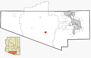
Sells is an unincorporated community and census-designated place (CDP) in Pima County, Arizona, United States. The population was 2,799 at the 2000 census. It is the capital of the Tohono O'odham Nation and the home of several of their tribal businesses, such as Tohono O'Odham Ki:Ki Association. Originally named Indian Oasis, by cattle-ranchers/businessmen brothers, Joseph and Louis Ménager in 1912. The Ménager brothers also built and ran the Indian Oasis Mercantile Store. The settlement took its present English name in 1918 to honor Indian Commissioner Cato Sells. The O'odham name means "Tortoise Got Wedged".

Ak-Chin Village is a census-designated place (CDP) in Pinal County, Arizona, United States on the Ak-Chin (Maricopa) Reservation. The population was 862 at the 2010 census, up from 669 in 2000.

Chuichu is a census-designated place (CDP) in Pinal County, Arizona, United States. The population was 308 at the 2020 census. It is the northernmost traditional village on the Tohono O'odham Nation reservation.

Sonoita is a census-designated place (CDP) in Santa Cruz County, Arizona, United States. The population was 818 at the 2010 census.

Topawa is a census-designated place and unincorporated community in Pima County, Arizona, United States. The population was 315 as of the 2020 census. Topawa is located on the Tohono O'odham Nation reservation, 7.5 miles (12.1 km) south-southeast of Sells. Topawa has a post office with ZIP code 85639.

Kaka is a census-designated place (CDP) in Maricopa County, Arizona, United States, located in the Tohono O'odham Nation. The population was 83 at the 2020 census, down from 141 at the 2010 census.
Kohatk is a census-designated place (CDP) in Pinal County, Arizona, United States, located in the northern part Tohono O'odham Nation reservation. The population was 31 as of the 2020 census.
Santa Cruz is a census-designated place (CDP) in Pinal County, Arizona, United States, located in the Gila River Indian Community. The population was 37 at the 2010 census.

Stotonic is a census-designated place (CDP) in Pinal County, Arizona, United States, located in the Gila River Indian Community. The population was 659 at the 2010 census. Stotonic Village has a median household income of $2,499 – the lowest of any CDP in Arizona

Sweet Water Village is a census-designated place (CDP) in Pinal County, Arizona, United States, located in the Gila River Indian Community. The population was 83 at the 2010 census.
Gu Oidak is a census-designated place (CDP) located within the Tohono O'odham Nation Division in Pima County, Arizona, United States. The population was 198 at the 2020 census. The name "Gu Oidak" is the O'odham term for "big field" and located on the Tohono O'odham Nation reservation.
Chiawuli Tak is both a census-designated place (CDP) as well as a populated place in Pima County, Arizona, United States. Chiawuli Tak means "the barrel cactus sits" in the O'odham language. It is also unofficially known as Geowic, Jeowic, or Tjeavolitak. The population was 78 at the 2010 census.
Nolic is a census-designated place (CDP) located on the Tohono O'odham Indian Reservation in Pima County, Arizona, United States. The population was 37 at the 2010 census.
South Komelik (O'odham) name translates as "South Flat", is a census-designated place in Pima County, in the U.S. state of Arizona. The population was 117 as of the 2020 census. It's located in the southern part of the Tohono O'odham Nation reservation near the border with Mexico.

San Miguel is a census-designated place in Pima County, in the U.S. state of Arizona. The population was 207 as of the 2020 census. San Miguel is located near the border with Mexico on the Tohono O'odham Nation reservation.

Ventana is a census-designated place in Pima County, in the U.S. state of Arizona. The population was 52 at the 2020 census. The place takes it name from the Spanish word for "window" and is located in the northeastern part of the Tohono O'odham Nation reservation.

Wahak Hotrontk also known as San Simon (O'odham) name translates as "Road Dips", is a census-designated place in Pima County, in the U.S. state of Arizona. The population was 120 as of the 2020 census. It is located along Arizona State Route 86 on the Tohono O'odham Nation reservation.

Vaiva Vo (O'odham) name translates as "Cocklebur Pond", is a census-designated place in Pinal County, in the U.S. state of Arizona. Its population was 93 as of the 2020 census. It is located on the northwestern part of the Tohono O'odham Nation reservation.


