Casas Adobes, Arizona

Last updated

Casas Adobes, Arizona
CDP
Tohono Chul wall.jpg
Garden in Tohono Chul Park
Pima County Incorporated and Unincorporated areas Casas Adobes highlighted.svg
Location in Pima County and Arizona
Usa edcp location map.svg
Red pog.svg
Casas Adobes, Arizona
Location in the United States
Coordinates: 32°20′47″N111°0′35″W / 32.34639°N 111.00972°W / 32.34639; -111.00972
CountryUnited States
State Arizona
County Pima
Area
[1]
  Total26.75 sq mi (69.29 km2)
  Land26.64 sq mi (69.01 km2)
  Water0.11 sq mi (0.28 km2)
Elevation
2,411 ft (735 m)
Population
 (2020)
  Total70,973
  Density2,663.65/sq mi (1,028.43/km2)
Time zone UTC-7 (MST (no DST))
FIPS code 04-10670
GNIS ID 37210
Moorish garden detail, Tohono Chul Park, Casas Adobes Moorish garden, Casa Adobes.jpg
Moorish garden detail, Tohono Chul Park, Casas Adobes

Casas Adobes (Spanish: "Adobe Houses") is an unincorporated community and census-designated place (CDP) located in the northern metropolitan area of Tucson, Arizona (in Pima County). The population was 66,795 at the 2010 census. Casas Adobes is situated south and southwest of the town of Oro Valley, and west of the community of Catalina Foothills.

Contents

The attempted assassination of Representative Gabby Giffords, and the murders of chief judge for the U.S. District Court for Arizona, John Roll, and five other people on January 8, 2011, took place at a Safeway supermarket in Casas Adobes.

History

Though Casas Adobes is an unincorporated community, it is older than both the towns of Oro Valley and Marana. [2]

The area bordering the Cañada del Oro in the north, and the Rillito River in the south was primarily inhabited and utilized by cattle ranchers. Cattle ranches dominated the Casas Adobes area until the 1920s, when Tucson had grown far enough north and the advent of the automobile made the area more easily accessible. [2]

One of the first individuals to build a home in the area was Maurice L. Reid, who came to Tucson in 1923 seeking a "walking cure" for tuberculosis. In the late 1920s Reid bought a 1,500 acres (6.1 km2) former ranch, bounded by North Oracle Road to the east, Orange Grove Road to the south, Ina Road to the north, and North La Cholla Boulevard to the west. Reid planted more than 200 acres (0.81 km2) of citrus trees and date palms, that would become the heart of Tucson's citrus industry. [2] Over the years, Reid sold parcels of land for home sites, and in 1950 he sold the last of his land. Some larger residential estates continue to maintain the remaining citrus groves and orchards nearly a century later.

Leonie Boutall, who relocated to Arizona from Tennessee, decided to build a guest ranch in the early 1930s. The dry climate, her doctor told her, would relieve her bronchial troubles. Boutall bought 100 acres (0.40 km2) of former ranch land just west of North Oracle Road, and south of a narrow dirt track now called Orange Grove Road. She built Rancho Nezhone, a luxury guest ranch that drew the rich and famous to the sparsely settled area far north of Tucson. [2] Kate Smith, Liberace, Gen. John Pershing and William "Hopalong Cassidy" Boyd were guests of the desert retreat which featured lush vegetation with monkeys and parrots. Boutall sold out of the property in 1948. [2] Today the site is home to Mission Palms Apartments, where much of the original flora and several features remain, including a 300-stone wall in front of the property. [3]

Sam Nanini and Giaconda, his wife, moved to Tucson in 1948 seeking to cure Giaconda Nanini's bronchial asthma. [2] Beginning in the mid-1950s, the Italian born, transplanted Chicagoan developed three residential subdivisions on about 300 acres (1.2 km2) that became the heart of the Casas Adobes community, giving the community its name. The subdivisions, along with Sam Nanini's landmark Casas Adobes Plaza, were considered by many to be Tucson's first suburb. [4] Most of the homes in the subdivision are large ranch-style homes built with adobe bricks. Sam Nanini and his son William also later built the world-class Tucson National Resort, and the million-dollar residential subdivision, the Tucson National Estates. [2]

1997 incorporation attempt

In 1997, the Arizona legislature passed a law that suspended the ability of incorporated cities and towns in Pima County to prevent the incorporation of other cities within six miles of their borders for a period of approximately two years. [5] That same year, the residents of Casas Adobes voted to incorporate as their own city. However, a series of appeals overturned the new law on constitutional grounds, and the Superior Court annulled the incorporation. A second vote for incorporation in 2001 failed 56 to 44 percent. [6]

Casas Adobes community has grown to encompass a 23-square-mile (60 km2) area inhabited by nearly 60,000 residents. [2] While Casas Adobes' neighboring municipalities of Oro Valley, Marana and Tucson continue to build new homes and shopping centers, Casas Adobes is mostly built out. With the failure of incorporation attempts, it is likely that one or all three of the neighboring entities will annex portions of Casas Adobes in the future. [2]

2011 shooting

On January 8, 2011, 19 people were shot during a Congresswoman's meeting in a Safeway grocery store parking lot. [7] Six people were killed, including a federal judge, John Roll, and a congressional aide. U.S. Representative for Arizona's 8th congressional district , Gabby Giffords, was shot in the head at close range. [8] A 22-year-old local man named as Jared Lee Loughner was arrested in connection with the incident. [9]

Geography

Casas Adobes is located at 32°20′47″N111°0′35″W / 32.34639°N 111.00972°W / 32.34639; -111.00972 (32.346368, −111.009844). [10]

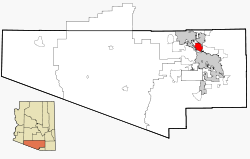
According to the United States Census Bureau, the CDP has a total area of 22.6 square miles (58.6 km2), of which 22.6 square miles (58.6 km2) is land and 0.04% is water.

Demographics

Historical population
CensusPop.Note
2000 54,011
2020 70,973
U.S. Decennial Census [11]

As of the census [12] of 2000, there were 54,011 people, 22,066 households, and 14,718 families residing in the CDP. The population density was 2,386.7 inhabitants per square mile (921.5/km2). There were 23,655 housing units at an average density of 1,045.3 per square mile (403.6/km2). The racial makeup of the CDP was 88.7% White, 1.7% Black or African American, 0.7% Native American, 2.2% Asian, 0.1% Pacific Islander, 4.5% from other races, and 2.3% from two or more races. 13.8% of the population were Hispanic or Latino of any race.

There were 22,066 households, out of which 29.8% had children under the age of 18 living with them, 54.3% were married couples living together, 9.2% had a female householder with no husband present, and 33.3% were non-families. 26.9% of all households were made up of individuals, and 10.2% had someone living alone who was 65 years of age or older. The average household size was 2.40 and the average family size was 2.93.

In the CDP, the population was spread out, with 23.0% under the age of 18, 8.0% from 18 to 24, 28.2% from 25 to 44, 24.6% from 45 to 64, and 16.1% who were 65 years of age or older. The median age was 39 years. For every 100 females, there were 90.2 males. For every 100 females age 18 and over, there were 86.7 males.

The median income for a household in the CDP was $49,736, and the median income for a family was $57,926. Males had a median income of $40,323 versus $29,892 for females. The per capita income for the CDP was $24,230. About 3.9% of families and 5.3% of the population were below the poverty line, including 5.2% of those under age 18 and 5.0% of those age 65 or over.

Education

Primary and secondary schools

Casas Adobes is served by three public school districts: [13]

Public libraries

Pima County Public Library operates the Nanini Branch Library in Casas Adobes. [26]

Points of interest

Westward Look Resort garden, 2014 Westward Look Resort.jpg
Westward Look Resort garden, 2014

Casas Adobes is the location of one of southern Arizona's largest and most biologically diverse nature preserves. Tohono Chul Park is a private nature park located northwest of North Oracle and West Ina roads on North Paseo del Norte. Tohono Chul, Tohono O'odham for "desert corner," was created in 1985 after Richard and Jane Wilson dedicated their historic home and property to the preservation of the desert and the education of visitors on the splendor of the native plants and wildlife. [2]

Casas Adobes features one of the highest concentrations of Mid-century modern architecture in the Tucson area with many prominent architects including Friedman and Jobusch, [27] Nicholas Sakellar, [28] Tom Gist, [29] [30] and Edward Nelson [31] designing properties in the region. Notable examples include Saint Odilia Catholic Church, [32] St Andrew's Presbyterian Church, [31] Dove of Peace Lutheran Church, [33] Arizona Bank (now Bank of America) as well as numerous residences in Catalina Village, Westward Look Estates, Casas Adobes Estates and Samalayuca Estates among other neighborhoods. [34]

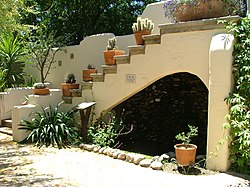
The Casas Adobes Plaza is a retail destination, dating back to 1948. The Plaza is situated on the southwest corner of North Oracle and West Ina roads, and features some of the most authentic Mediterranean architecture in the area. Original Italian vignettes, statues, and fountains are incorporated into the plaza. Casas Adobes Plaza has a historic Mediterranean observation tower.

Westward Look Resort is located in Casas Adobes, beginning in the early 20th century as a dude ranch in the foothills of the Santa Catalina Mountains north of Tucson. The property was significantly expanded in the late 1960s by modernist architect Edward Nelson [31] and became the Tucson area's first resort. The original adobe home commissioned by ranch founders William and Maria Watson in the 1910s by Tucson architect Merritt Starkweather remains the heart of Westward Look Resort and is named the "Vigas Room." [35]

Casas Adobes has a nationally prominent golf resort built in the 1960s by Sam Nanini, the Omni Tucson National Resort. Hosting the PGA Tour Tucson Open for more than forty years, golfers Jack Nicklaus (who was discovered and promoted by Nanini), Arnold Palmer, Lee Trevino, Tom Watson, Tom Kite and Johnny Miller have played at Tucson National. Early tournaments were celebrity-hosted by Dean Martin and others. [36]

While Casas Adobes remains unincorporated, the community has distinguished itself from the other suburbs to the north and northwest of Tucson as the oldest community.

See also

Related Research Articles

<span class="mw-page-title-main">Tucson, Arizona</span> City in Arizona, United States

Tucson is a city in and the county seat of Pima County, Arizona, United States, and is home to the University of Arizona. It is the second-largest city in Arizona behind Phoenix, with a population of 542,629 in the 2020 United States census, while the population of the entire Tucson metropolitan statistical area (MSA) is 1,043,433. The Tucson MSA forms part of the larger Tucson-Nogales combined statistical area. Both Tucson and Phoenix anchor the Arizona Sun Corridor. The city is 108 miles (174 km) southeast of Phoenix and 60 mi (97 km) north of the United States–Mexico border. Tucson is the 34th-largest city and the 53rd-largest metropolitan area in the United States (2014).

<span class="mw-page-title-main">Pima County, Arizona</span> County in Arizona, United States

Pima County is a county in the south central region of the U.S. state of Arizona. As of the 2020 census, the population was 1,043,433, making it Arizona's second-most populous county. The county seat is Tucson, where most of the population is centered. The county is named after the Pima Native Americans who are indigenous to this area.

<span class="mw-page-title-main">Santa Cruz County, Arizona</span> County in Arizona, United States

Santa Cruz is a county in southern Arizona, United States. As of the 2020 census, the population is 47,669. The county seat is Nogales. The county was established in 1899. It borders Pima County to the north and west, Cochise County to the east, and the Mexican state of Sonora to the south.

<span class="mw-page-title-main">Catalina, Arizona</span> CDP in Pima County, Arizona

Catalina is a census-designated place (CDP) in Pima County, Arizona, United States. The population was 7,025 at the 2000 census. Catalina continues to experience increasing population growth, while attempting to maintain its rural character. Catalina remains an unincorporated community, with no plans for annexation into any nearby towns.

<span class="mw-page-title-main">Catalina Foothills, Arizona</span> CDP in Pima County, Arizona

Catalina Foothills is an unincorporated community and census-designated place (CDP) located north of Tucson in Pima County, Arizona, United States. Situated in the southern foothills of the Santa Catalina Mountains, Catalina Foothills had a population of 50,796 at the 2010 census. Catalina Foothills is one of the most affluent communities in Arizona and in the U.S., with the 6th highest per capita income in Arizona, and the 14th highest per capita income in the U.S. of communities with a population of at least 50,000. The Catalina Foothills community includes some of Arizona's most expensive homes and land, and has the highest median property value. It also includes resorts, golf courses, and spas.

<span class="mw-page-title-main">Flowing Wells, Arizona</span> CDP in Pima County, Arizona

Flowing Wells is a census-designated place (CDP) in Pima County, Arizona, United States. It is a suburb of Tucson. The population was 16,419 at the 2010 census.

<span class="mw-page-title-main">Marana, Arizona</span> Town in Pima County, Arizona

Marana is a town in Pima County, Arizona, United States, located northwest of Tucson, with a small portion in Pinal County. According to the 2021 Census, the population of the town was 54,895. From 1990 to 2000, Marana was the fourth fastest-growing place among all cities and towns of any size in Arizona.

<span class="mw-page-title-main">Oro Valley, Arizona</span> Town in Pima County, Arizona

Oro Valley, incorporated in 1974, is a suburban town located 6 miles (9.7 km) north of Tucson, Arizona, United States, in Pima County. According to the 2020 census, the population of the town is 47,070, an increase from 29,700 in 2000. Dubbed the "Upscale Tech Mecca" of Southern Arizona by the Arizona Daily Star newspaper, Oro Valley is home to over 10 high tech firms and has a median household income nearly 50% higher than the U.S. median. The town is located approximately 110 miles (180 km) southeast of the state capital of Phoenix.

<span class="mw-page-title-main">Tortolita, Arizona</span> Former CDP in Arizona, United States

Tortolita was a census-designated place (CDP) in Pima County, Arizona, United States. The population was 3,740 at the 2000 census. Tortolita was situated between the growing incorporated towns of Oro Valley and Marana with most of the area previously part of the CDP having been annexed by the two towns during the 2000s. The remaining parts of the CDP that have not been annexed continue to be unincorporated portions of Pima County.

<span class="mw-page-title-main">Sacaton, Arizona</span> CDP in Pinal County, Arizona

Sacaton is a census-designated place (CDP) in Pinal County, Arizona, United States. The population was 3,254 at the 2020 census. It is the capital of the Gila River Indian Community.

<span class="mw-page-title-main">Amphitheater Public Schools</span>

Amphitheater Public Schools, also known as Amphi or District 10, is the third largest public school district in Tucson, Arizona, in terms of enrollment, with about 13,500 students and a staff of about 2000 employees Amphi was established on July 3, 1893. With its headquarters in Flowing Wells, presently serves segments of North Tucson, Casas Adobes, Catalina Foothills, and the communities of Oro Valley, eastern Tortolita, and Catalina northwest of the city.

The Explorer Newspaper is a weekly newspaper in Tucson, Arizona, United States.

<span class="mw-page-title-main">Marana Unified School District</span> School district in Arizona, United States

Marana Unified School District (MUSD) is an above average, public school district located in Marana, AZ, comprising 17 schools in Pima County, Arizona. It has its headquarters in Marana. It has 12,293 students in grades PK, K-12 with a student-teacher ratio of 19 to 1, about 650 teachers. According to state test scores, 42% of students are at least proficient in math and 42% in reading. Founded in the early 1920s, MUSD's boundaries include 550 square miles (1,400 km2) of land.

Foothills Mall was an indoor regional shopping mall located in Casas Adobes, Arizona, United States, with a Tucson postal address. Foothills Mall had capacity for over 90 stores and outlets, along with 8 restaurants and an AMC Theatres Foothills 15. As of 2023, the mall is undergoing partial demolition, with plans to convert the existing mall into a mixed-use project.

<span class="mw-page-title-main">Pima County Public Library</span> Public libraries in Arizona, United States

The Pima County Public Library (PCPL) system serves Pima County, Arizona, with a main library and 26 branch libraries as well as a bookmobile service. The system has its headquarters in Tucson with a service area including the city and the surrounding communities of Arivaca, Green Valley, Sahuarita, South Tucson, Ajo, Vail, Marana, Casas Adobes, and Catalina. The town of Oro Valley's library joined the Pima County Public Library system in July 2012.

The Flowing Wells Unified School District is a unified school district headquartered at 1556 West Prince Road, Tucson, Arizona. It serves much of Flowing Wells, as well as bits of Tucson, Marana, Cortaro, Casas Adobes, & unnamed, unincorporated parts of Pima County. The district does practice open enrollment for students outside of district boundaries, provided said students maintain certain academic performance.

Casas Adobes Plaza is an upscale shopping mall located at the southwest corner of North Oracle Road and East Ina Road in Casas Adobes, Arizona, just northwest of Tucson.

<span class="mw-page-title-main">Casa Blanca, Arizona</span> CDP in Pinal County, Arizona

Casa Blanca is a census-designated place (CDP) in Pinal County, Arizona, United States, located in the Gila River Indian Community. The population was 1,388 at the 2010 census.

The Loop is a network of shared-use paths in metropolitan Tucson, Arizona maintained by Pima County. Once complete it will comprise 131 miles (211 km) of paved trails dedicated to cyclist, pedestrian, and equestrian use. By 2014, the network was 85% complete, with over one hundred miles in place. Pima County estimates the Loop is used by an average of 2,000 visitors each weekday and more than 5,000 on weekends.

Nelson is a census-designated place (CDP) in Pima County, Arizona, United States. The population was 259 at the 2010 census.

References

  1. "2020 U.S. Gazetteer Files". United States Census Bureau. Retrieved October 29, 2021.
  2. 1 2 3 4 5 6 7 8 9 10 "Casas Adobes - Northern Pima County Communities". Archived from the original on August 30, 2011. Retrieved August 1, 2023.{{cite web}}: CS1 maint: unfit URL (link)
  3. "Additional Notes for Rancho Nezhone (guest ranch)". The University of Arizona Health Sciences Library. Archived from the original on October 29, 2017. Retrieved October 28, 2017.
  4. "About the Tucson Region". Senior Resource Guide. Archived from the original on October 30, 2017. Retrieved October 28, 2017.
  5. "Town of Tortolita v. Napolitano". March 29, 2001. Retrieved June 6, 2018.
  6. "Casas Adobes Incorporation Election, What It Means To You". March 14, 2001. Retrieved June 6, 2018.
  7. "Arizona congresswoman among 19 shot at Tucson grocery". CNN. January 8, 2011. Archived from the original on January 10, 2014. Retrieved January 8, 2011.
  8. "US congresswoman Gabrielle Giffords shot in Arizona". BBC News. January 8, 2011.
  9. "Jared Lee Loughner Identified as Gabrielle Giffords Shooter". huffingtonpost.com. January 8, 2011. Retrieved January 8, 2011.
  10. "US Gazetteer files: 2010, 2000, and 1990". United States Census Bureau. February 12, 2011. Retrieved April 23, 2011.
  11. "Census of Population and Housing". Census.gov. Retrieved June 4, 2016.
  12. "U.S. Census website". United States Census Bureau . Retrieved 2008-01-31.
  13. "2020 CENSUS - SCHOOL DISTRICT REFERENCE MAP: Pima County, AZ" (PDF). U.S. Census Bureau. p. 2. Retrieved January 25, 2023.
  14. "America's Best High Schools: The List". newsweek.com. p. 84. Retrieved June 3, 2011.
  15. "District Map and Boundaries". Amphitheater Public Schools. Retrieved October 28, 2017.
  16. "Welcome to Donaldson! Archived February 17, 2011, at the Wayback Machine " Marion Donaldson Elementary School. Retrieved on January 18, 2011. "2040 W. Omar Drive Tucson, AZ"
  17. "Welcome to Harelson Elementary School Archived January 26, 2011, at the Wayback Machine ." Harelson Elementary School. Retrieved on January 18, 2011. "826 W. Chapala Drive, Tucson, AZ"
  18. "Welcome to Mesa Verde Elementary School Archived December 28, 2010, at the Wayback Machine ." Mesa Verde Elementary School. Retrieved on January 18, 2011. "1661 W.Sage Tucson, AZ"
  19. "Home Archived January 8, 2011, at the Wayback Machine ." Lulu Walker Elememtary School. Retrieved on January 18, 2011. "1750 W. Roller Coaster Rd. Tucson, AZ"
  20. "Welcome to La Cima Middle School! Archived December 21, 2010, at the Wayback Machine " La Cima Middle School. Retrieved on January 18, 2011.
  21. "Map and Boundaries". Marana Unified School District. Archived from the original on October 29, 2017. Retrieved October 28, 2017.
  22. "Welcome to the Bobcat Den Archived December 18, 2010, at the Wayback Machine ." Butterfield Elementary School. Retrieved on January 18, 2011. "3400 W. Massingale Road Tucson, AZ" (Direct image link Archived December 17, 2010, at the Wayback Machine )
  23. "Welcome to Ironwood Elementary Archived December 18, 2010, at the Wayback Machine ." Ironwood Elementary School. Retrieved on January 18, 2011. "Ironwood Elementary 3300 W. Freer Drive Tucson, AZ"
  24. "Thornydale Thundercats Archived December 18, 2010, at the Wayback Machine ." Thornydale Elementary School. Retrieved on January 18, 2011. "7651 N. Oldfather Tucson, AZ" Direct image link Archived December 17, 2010, at the Wayback Machine
  25. "flowingwellsschools.org". flowingwellsschools.org. Retrieved October 28, 2017.
  26. "Nanini Branch Library Archived July 27, 2011, at the Wayback Machine ." Pima County Public Library. Retrieved on January 18, 2011. "7300 N. Shannon Rd. Tucson, AZ" Map Archived November 22, 2010, at the Wayback Machine
  27. "Bernard J. Friedman 1916 – 2012". Tucson Historic Preservation Foundation. Retrieved October 28, 2017.
  28. "Nicholas Sakellar, FAIA 1918–1993". Tucson Historic Preservation Foundation. Retrieved October 28, 2017.
  29. "Tom Gist 1917-2000". Tucson Historic Preservation Foundation. Retrieved October 28, 2017.
  30. "6431 N Treasure Drive, Tucson, AZ". Long Realty. Retrieved October 28, 2017.
  31. 1 2 3 "Edward Nelson". Tucson Historic Preservation Foundation. Retrieved October 28, 2017.
  32. "Saint Odilia Catholic Church" (PDF). University of Arizona College of Architecture, Planning & Landscape Architecture. Archived from the original (PDF) on October 29, 2017. Retrieved October 28, 2017.
  33. "Dove of Peace Lutheran Church" (PDF). University of Arizona College of Architecture, Planning & Landscape Architecture. Archived from the original (PDF) on October 29, 2017. Retrieved October 28, 2017.
  34. "Residential Real Estate Search". University of Arizona College of Architecture, Planning & Landscape Architecture. Archived from the original on October 24, 2016. Retrieved October 28, 2017.
  35. "Westward Look History". Westward Look Wyndham Grand Resort & Spa. Retrieved October 28, 2017.
  36. "Our Story". Omni Tucson National Resort. Retrieved October 28, 2017.

Commons-logo.svg Media related to Casas Adobes, Arizona at Wikimedia Commons