Drexel Heights, Arizona

Last updated

Drexel Heights, Arizona
CDP
Rainbow over Drexel Heights, AZ, USA.jpg
A rainbow appearing after a monsoon in Drexel Heights, Arizona, USA.
Pima County Incorporated and Unincorporated areas Drexel Heights highlighted.svg
Location in Pima County and the state of Arizona
Usa edcp location map.svg
Red pog.svg
Drexel Heights, Arizona
Location in the United States
Coordinates: 32°8′34.49″N111°1′35.53″W / 32.1429139°N 111.0265361°W / 32.1429139; -111.0265361
Country United States
State Arizona
County Pima
Area
[1]
  Total19.25 sq mi (49.85 km2)
  Land19.25 sq mi (49.85 km2)
  Water0.00 sq mi (0.00 km2)
Elevation
2,526 ft (770 m)
Population
 (2020)
  Total27,523
  Density1,429.99/sq mi (552.13/km2)
Time zone UTC-7 (MST (no DST))
FIPS code 04-20540
GNIS feature ID0025237

Drexel Heights is an unincorporated community and census-designated place (CDP) in Pima County, Arizona, United States. The population was 27,749 at the 2010 census.

Contents

The area is said to be named after financier Francis Anthony Drexel, the father of Saint Katharine Drexel (who established missions to Blacks and Native Americans throughout the United States). Drexel is said to have owned property in the Drexel Heights area and eastward during the late 19th century, although no proof has ever been found that he owned land in the area. Francis A. Drexel died in 1885.

In an article in the Arizona Daily Star newspaper, on March 4, 2014, historian David Leighton stated that Drexel Road was named after Katharine Drexel, and that her father Francis A. Drexel didn't own land in the area as has been claimed in the past. While Mr. Leighton, didn't directly state that Drexel Heights was named in honor of Saint Katharine Drexel, it is implied in his statement that it is named in her honor. [2]

Geography

Drexel Heights is located at 32°8′20″N111°2′38″W / 32.13889°N 111.04389°W / 32.13889; -111.04389 (32.138989, -111.043926). [3]

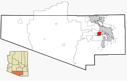
According to the United States Census Bureau, the CDP has a total area of 19.7 square miles (51 km2), all land.

The area has numerous Saguaro cacti, and is positioned only a couple of miles south of the Saguaro National Park. The northern boundary of Drexel Heights is the Tucson Mountain Park. It is cut off from the rest of Tucson due to the topography of the Tucson Mountains, which are only crossed via a small number of roads: Ajo Highway is the main crossing, with Gates Pass providing a more scenic route. Coyotes and Javalinas are commonly sighted in the area.

Demographics

Historical population
CensusPop.Note
2000 23,849
2010 27,74916.4%
2020 27,523−0.8%
U.S. Decennial Census [4]

As of the census [5] of 2000, there were 23,849 people, 7,505 households, and 5,988 families residing in the CDP. The population density was 1,212.1 inhabitants per square mile (468.0/km2). There were 7,957 housing units at an average density of 404.4 per square mile (156.1/km2). The racial makeup of the CDP was 58.1% White, 2.6% Black or African American, 3.4% Native American, 0.8% Asian, 0.1% Pacific Islander, 31.3% from other races, and 3.6% from two or more races. 60.1% of the population were Hispanic or Latino of any race.

In the CDP, the population was spread out, with 31.9% under the age of 18, 9.4% from 18 to 24, 28.6% from 25 to 44, 22.0% from 45 to 64, and 8.1% who were 65 years of age or older. The median age was 32 years. For every 100 females, there were 97.1 males. For every 100 females age 18 and over, there were 92.1 males.

As of the census of 2010, The racial makeup of the CDP was 58.6% White, 2.5% Black or African American, 2.3% Native American, 0.7% Asian, 0.1% Pacific Islander, 28.5% from other races, and 4.3% from two or more races. 70.6% of the population were Hispanic or Latino of any race. There were 8,824 households, out of which 57.2% had children under the age of 18 living with them, 59.8% were married couples living together, 17.2% had a female householder with no husband present, and 23.0% were non-families. 17.2% of all households were made up of individuals, and 2.4% had someone living alone who was 65 years of age or older. The average household size was 3.14 and the average family size was 3.54.

Ecology

Drexel Heights enjoys abundant urban wildlife but not everyone enjoys it. [6] The Fire Department has decided to release captured nuisance wildlife near town to avoid excessive ecological disruption, but this has increased the number of animals returning to the originally reported location. [6]

Related Research Articles

<span class="mw-page-title-main">Pima County, Arizona</span> County in Arizona, United States

Pima County is a county in the south central region of the U.S. state of Arizona. As of the 2020 census, the population was 1,043,433, making it Arizona's second-most populous county. The county seat is Tucson, where most of the population is centered. The county is named after the Pima Native Americans, also known as Tohono O'odham, who are indigenous to this area.

<span class="mw-page-title-main">Kipnuk, Alaska</span> CDP in Alaska, United States

Kipnuk is a census-designated place (CDP) in Bethel Census Area, Alaska, United States. At the 2010 census the population was 639, down from 644 in 2000.

<span class="mw-page-title-main">St. Michaels, Arizona</span> CDP in Apache County, Arizona

St. Michaels is a chapter of the Navajo Nation and a census-designated place (CDP) in Apache County, Arizona, United States. The Navajo Nation Government Campus is located within the chapter at Window Rock.

<span class="mw-page-title-main">Ajo, Arizona</span> Community in Pima County, Arizona

Ajo is an unincorporated community in Pima County, Arizona, United States. It is the closest community to Organ Pipe Cactus National Monument. The population was 3,039 at the 2020 census. Ajo is located on State Route 85 just 43 miles (69 km) from the Mexican border.

<span class="mw-page-title-main">Avra Valley, Arizona</span> CDP in Pima County, Arizona

Avra Valley is a census-designated place (CDP) in Pima County, Arizona, United States. The population was 6,050 at the 2010 census, up from 5,038 in 2000.

<span class="mw-page-title-main">Catalina, Arizona</span> CDP in Pima County, Arizona

Catalina is a census-designated place (CDP) in Pima County, Arizona, United States. The population was 7,025 at the 2000 census. Catalina continues to experience increasing population growth, while attempting to maintain its rural character. Catalina remains an unincorporated community, with no plans for annexation into any nearby towns.

<span class="mw-page-title-main">Catalina Foothills, Arizona</span> CDP in Pima County, Arizona

Catalina Foothills is an unincorporated community and census-designated place (CDP) located north of Tucson in Pima County, Arizona, United States. Situated in the southern foothills of the Santa Catalina Mountains, Catalina Foothills had a population of 50,796 at the 2010 census. Catalina Foothills is one of the most affluent communities in Arizona and in the U.S., with the 6th highest per capita income in Arizona, and the 14th highest per capita income in the U.S. of communities with a population of at least 50,000. The Catalina Foothills community includes some of Arizona's most expensive homes and land, and has the highest median property value. It also includes resorts, golf courses, and spas.

<span class="mw-page-title-main">Drexel-Alvernon, Arizona</span> CDP in Pima County, Arizona

Drexel-Alvernon was a census-designated place (CDP) in Pima County, Arizona, United States. The population was 4,192 at the 2000 census.

<span class="mw-page-title-main">Flowing Wells, Arizona</span> CDP in Pima County, Arizona

Flowing Wells is a census-designated place (CDP) in Pima County, Arizona, United States. It is a suburb of Tucson. The population was 16,419 at the 2010 census.

<span class="mw-page-title-main">Littletown, Arizona</span> CDP in Pima County, Arizona

Littletown was a census-designated place (CDP) in Pima County, Arizona, United States. The population was 1,010 at the 2000 census. The area was annexed into Tucson in 2017.

<span class="mw-page-title-main">Marana, Arizona</span> Town in Pima County, Arizona

Marana is a town that mostly lies in Pima County with a small portion in Pinal County, in the U.S. state of Arizona. It is located northwest of Tucson, Arizona. As of the 2020 census, the population of the town was 51,908.

<span class="mw-page-title-main">Picture Rocks, Arizona</span> CDP in Pima County, Arizona

Picture Rocks is a census-designated place (CDP) in Pima County, Arizona, United States, home of the Tucson artifacts. The population was 9,551 at the 2020 United States census.

<span class="mw-page-title-main">Three Points, Arizona</span> CDP in Arizona, United States

Three Points is a census-designated place (CDP) in Pima County, Arizona, United States. The population was 5,581 at the 2010 census.

<span class="mw-page-title-main">Tucson Estates, Arizona</span> CDP in Arizona, United States

Tucson Estates is a census-designated place (CDP) in Pima County, Arizona, United States. The population was 9,755 at the 2000 census.

<span class="mw-page-title-main">Vail, Arizona</span> CDP in Pima County, Arizona

Vail is a census-designated place (CDP) in Pima County, Arizona, United States. It is 24 miles (39 km) southeast of Tucson. The population was 10,208 at the 2010 census, up from 2484 in the 2000 census. The area is known for the nearby Colossal Cave, a large cave system, and the Rincon Mountains District of Saguaro National Park, a top tourism spot within Arizona.

<span class="mw-page-title-main">Oracle, Arizona</span> CDP in Pinal County, Arizona

Oracle is a census-designated place (CDP) in Pinal County, Arizona, United States. The population was 3,686 at the 2010 Census, falling to 3,051 at the 2020 Census.

<span class="mw-page-title-main">San Manuel, Arizona</span> CDP in Pinal County, Arizona

San Manuel is a census-designated place (CDP) in Pinal County, Arizona, United States. The population was 3,551 at the 2010 census.

<span class="mw-page-title-main">Stanfield, Arizona</span> CDP in Pinal County, Arizona

Stanfield is a census-designated place (CDP) in Pinal County, Arizona, United States. The population was 651 at the 2000 census. Shamrock Farms operates a farm in Stanfield.

<span class="mw-page-title-main">Riverdale Park, California</span> Census-designated place in California, United States

Riverdale Park is a census-designated place (CDP) in Stanislaus County, California, United States. The population was 1,128 at the 2010 census, up from 1,094 at the 2000 census. It is part of the Modesto Metropolitan Statistical Area.

Nelson is a census-designated place (CDP) in Pima County, Arizona, United States. The population was 259 at the 2010 census.

References

  1. "2020 U.S. Gazetteer Files". United States Census Bureau. Retrieved October 29, 2021.
  2. David Leighton, "Street Smarts: Generous nun the namesake for Drexel Road," Arizona Daily Star, March 4, 2014
  3. "US Gazetteer files: 2010, 2000, and 1990". United States Census Bureau. February 12, 2011. Retrieved April 23, 2011.
  4. "Census of Population and Housing". Census.gov. Retrieved June 4, 2016.
  5. "U.S. Census website". United States Census Bureau . Retrieved January 31, 2008.
  6. 1 2 Hanson, Jonathan (2004). There's a Bobcat in My Backyard!: Living with and Enjoying Urban Wildlife. Arizona-Sonora Desert Museum Guides. University of Arizona Press. ISBN   9780816521869.

32°08′20″N111°02′38″W / 32.138989°N 111.043926°W / 32.138989; -111.043926