Nelson, Pima County, Arizona

Last updated

Nelson, Arizona
CDP
USA Arizona location map.svg
Red pog.svg
Nelson
Location within the state of Arizona
Usa edcp location map.svg
Red pog.svg
Nelson
Nelson (the United States)
Coordinates: 32°25′47″N111°15′54″W / 32.42972°N 111.26500°W / 32.42972; -111.26500
CountryUnited States
State Arizona
County Pima
Area
[1]
  Total0.47 sq mi (1.23 km2)
  Land0.47 sq mi (1.23 km2)
  Water0.00 sq mi (0.00 km2)
Elevation
[2]
1,975 ft (602 m)
Population
 (2020)
  Total249
  Density525.32/sq mi (203.02/km2)
Time zone UTC-7 (MST)
Area code 520
FIPS code 04-49100
GNIS feature ID 2582830

Nelson is a census-designated place (CDP) in Pima County, Arizona, United States. The population was 259 at the 2010 census. [3]

Contents

History

As early as 1934, Nelson appeared as a named location, [4] remaining undeveloped until 1973. [5] At the 2010 census, the area was designated as a CDP in Pima County, listed as part of the Marana CCD. [3]

Geography

Nelson is located at 32°25′47″N111°15′54″W / 32.42972°N 111.26500°W / 32.42972; -111.26500 (32.42981, −111.264924). According to the United States Geological Survey, the CDP has a total area of 0.48 square miles (1.2 km2), all land. [2] [6]

Demographics

Historical population
CensusPop.Note
2020 249
U.S. Decennial Census [7]

As of the 2010 census, there were 259 people living in the CDP: 123 male and 136 female. 73 were 19 years old or younger, 55 were ages 20–34, 49 were between the ages of 35 and 49, 55 were between 50 and 64, and the remaining 26 were aged 65 and above. The median age was 36.2 years.

The racial makeup of the CDP was 81.9% White, 1.5% American Indian, 1.5% Black or African American, 1.2% Asian, 13.5% Other, and 0.4% two or more races. 27% of the population were Hispanic or Latino of any race.

There were 89 households in the CDP, 66 family households (74.2%) and 23 non-family households (25.8%), with an average household size of 2.91. Of the family households, 44 were married couples living together, while there were 6 single fathers and 16 single mothers; the non-family households included 16 adults living alone: eight male and eight female.

The CDP contained 100 housing units, of which 89 were occupied and 11 were vacant. [8]

Related Research Articles

<span class="mw-page-title-main">Ajo, Arizona</span> Community in Pima County, Arizona

Ajo is an unincorporated community in Pima County, Arizona, United States. It is the closest community to Organ Pipe Cactus National Monument. The population was 3,039 at the 2020 census. Ajo is located on State Route 85 just 43 miles (69 km) from the Mexican border.

<span class="mw-page-title-main">Avra Valley, Arizona</span> CDP in Pima County, Arizona

Avra Valley is a census-designated place (CDP) in Pima County, Arizona, United States. The population was 6,050 at the 2010 census, up from 5,038 in 2000.

<span class="mw-page-title-main">Casas Adobes, Arizona</span> CDP in Pima County, Arizona

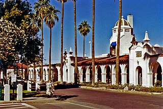
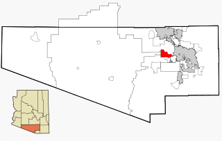
Casas Adobes is an unincorporated community and census-designated place (CDP) located in the northern metropolitan area of Tucson, Arizona. The population was 66,795 at the 2010 census. Casas Adobes is situated south and southwest of the town of Oro Valley, and west of the community of Catalina Foothills.

<span class="mw-page-title-main">Flowing Wells, Arizona</span> CDP in Pima County, Arizona

Flowing Wells is a census-designated place (CDP) in Pima County, Arizona, United States. It is a suburb of Tucson. The population was 16,419 at the 2010 census.

<span class="mw-page-title-main">Three Points, Arizona</span> CDP in Arizona, United States

Three Points is a census-designated place (CDP) in Pima County, Arizona, United States. The population was 5,581 at the 2010 census.

<span class="mw-page-title-main">Tucson Estates, Arizona</span> CDP in Arizona, United States

Tucson Estates is a census-designated place (CDP) in Pima County, Arizona, United States. The population was 9,755 at the 2000 census.

<span class="mw-page-title-main">Kaka, Arizona</span> CDP in Maricopa County, Arizona

Kaka is a census-designated place (CDP) in Maricopa County, Arizona, United States, located in the Tohono O'odham Nation. The population was 83 at the 2020 census, down from 141 at the 2010 census.

<span class="mw-page-title-main">Cowlic, Arizona</span> CDP in Pima County, Arizona

Cowlic or Kawulk (O'odham) name translates as "The Hill", is a census-designated place (CDP) in Pima County, Arizona, United States. The population was 147 as of the 2020 census. It is located on the Tohono O'odham Nation reservation.

Gu Oidak is a census-designated place (CDP) located within the Tohono O'odham Nation Division in Pima County, Arizona, United States. The population was 198 at the 2020 census. The name "Gu Oidak" is the O'odham term for "big field" and located on the Tohono O'odham Nation reservation.

Charco is both a census-designated place (CDP) and a populated place in Pima County, Arizona, United States. The population was 52 at the 2010 census.

Chiawuli Tak is both a census-designated place (CDP) as well as a populated place in Pima County, Arizona, United States. Chiawuli Tak means "the barrel cactus sits" in the O'odham language. It is also unofficially known as Geowic, Jeowic, or Tjeavolitak. The population was 78 at the 2010 census.

Comobabi is both a census-designated place (CDP) and a populated place in Pima County, Arizona, United States. The population was 8 at the 2010 census. It is located within the Tohono O'odham Indian Reservation.

El Prado Estates is a census-designated place (CDP) and colonia in Yuma County, Arizona, United States. The population was 504 at the 2010 census.

Haivana Nakya is a census-designated place (CDP) in Pima County, Arizona, United States. The population was 96 at the 2010 census.

Ko Vaya is a census-designated place (CDP) in Pima County, Arizona, United States. The population was 46 at the 2010 census.

Elephant Head is a census-designated place (CDP) in Pima County, Arizona, United States. The population was 612 at the 2010 census.

Lower Santan Village is a census-designated place (CDP) in Pinal County, Arizona, United States. The population was 374 at the 2010 census.

Maish Vaya is a census-designated place (CDP) in Pima County, Arizona, United States. The population was 158 at the 2010 census.

Nolic is a census-designated place (CDP) located on the Tohono O'odham Indian Reservation in Pima County, Arizona, United States. The population was 37 at the 2010 census.

Pimaco Two is a census-designated place (CDP) located in Pima County, Arizona, United States. The population was 682 at the 2010 census.

References

  1. "2020 U.S. Gazetteer Files". United States Census Bureau. Retrieved October 29, 2021.
  2. 1 2 "Feature Detail Report for: Nelson Census Designated Place". Geographic Names Information System . United States Geological Survey, United States Department of the Interior.
  3. 1 2 "Arizona: 2010 Population and Housing Unit Counts" (PDF). United States Census Bureau . Retrieved May 24, 2019.
  4. "USGS 1:125000-scale Quadrangle for Tucson Mountains, AZ 1934". United States Geological Survey. Archived from the original on May 25, 2019. Retrieved September 14, 2021.
  5. "MP-24-070". City of Tucson. May 13, 2014. Retrieved May 24, 2019.
  6. "Nelson, AZ Profile: Facts & Data". AZ Hometown Locator. Retrieved January 1, 2017.
  7. "Census of Population and Housing". United States Census Bureau. Retrieved June 4, 2016.
  8. "American FactFinder: Nelson CDP, Arizona". United States Census Bureau. Archived from the original on February 13, 2020. Retrieved January 1, 2017.