Related Research Articles

Fairbank is a ghost town in Cochise County, Arizona, next to the San Pedro River. First settled in 1881, Fairbank was the closest rail stop to nearby Tombstone, which made it an important location in the development of southeastern Arizona. The town was named for Chicago investor Nathaniel Kellogg Fairbank who partially financed the railroad, and was the founder of the Grand Central Mining Company, which had an interest in the silver mines in Tombstone. Today Fairbank is located within the San Pedro Riparian National Conservation Area.

Gleeson is a ghost town situated in southeastern Cochise County, Arizona, United States. It has an estimated elevation of 4,924 feet (1,501 m) above sea level. The town was first settled as Turquoise in the 1870s in what was then the Arizona Territory, then later re-established as Gleeson in 1900.

Charleston is a ghost town in Cochise County in the southeastern part of the U.S. state of Arizona. It was occupied from the late-1870s through the late-1880s, and was located in what was then known as the Arizona Territory. Located on the west bank of the San Pedro River, Charleston's economy was based on milling silver ore mined from nearby Tombstone in the community of Millville, located directly across the river.

Contention City or Contention is a ghost mining town in Cochise County in the southeastern part of the U.S. state of Arizona. It was occupied from the early-1880s through the late-1880s in what was then known as the Arizona Territory. Only a few foundations now remain of this boomtown which was settled and abandoned with the rise and fall of silver mining in and around the area of Tombstone.

Tiger is a former populated place in Pinal County in the U.S. state of Arizona. The town was settled as Schultzcirca 1881 in what was then the Arizona Territory, then later reestablished as Tiger after World War I.
Tip Top is a ghost town in Yavapai County in the U.S. state of Arizona. The town was settled in 1876 in what was then the Arizona Territory.

Total Wreck is a ghost town in Pima County, Arizona. The town was built 7 miles (11 km) from Pantano, Arizona, whence "an excellent road" led from the Southern Pacific Railroad line and on to the Empire Ranch. It lay on the mail route to and from Harshaw.

Canyon Diablo is a ghost town in Coconino County, Arizona, United States on the edge of the arroyo Canyon Diablo. The community was settled in 1880 and died out in the early 20th century.

Castle Dome Landing, Arizona is a ghost town in the Castle Dome Mountains of Yuma County in the U.S. state of Arizona. It was first settled as a transport depot and mining camp around 1863 in what was then the Arizona Territory.

Alamo Crossing is a ghost town in Mohave County, Arizona, United States. The town was settled in the late 1890s, in what was then the Arizona Territory. It served as a camp for mining prospectors in the manganese-rich Artillery Mountains, being the only town in the area. After 1918, the post office permanently closed, but the town was only intermittently abandoned, with its founders often present through until at least the mid-1950s. The town was intentionally flooded in 1968 to create Alamo Lake. In 2020, the area of Alamo was revived for mining again, this time for surface-level gold prospecting.
Mohave City is a ghost town in Mohave County in the northwestern part of the U.S. state of Arizona. Settled in the 1860s, in what was then the Arizona Territory, it was founded as a river landing and trading center for area miners and soldiers, and was named for Mohave County.

Alexandra is a ghost town in Yavapai County, Arizona, United States. The ghost town was settled during the frontier days of 1875 as a mining camp until abandoned in 1896. Alexandra is ten miles east of Mayer.
American Flag is a ghost town in Pinal County, Arizona, five miles southeast of Oracle. The town was established in the late 1870s, but shortly after 1890, the town had become abandoned.
Aubrey Landing, Aubrey City or Aubrey is a ghost town at the mouth of the Bill Williams River in southern Mohave County, Arizona, United States. The town was founded before 1865 and was abandoned sometime after 1886. Aubrey Landing was inundated when Lake Havasu was formed.

Big Bug is a ghost town in Yavapai County, Arizona, United States. The former settlement is located twelve miles southeast of Prescott and was established in 1862.
Cerbat is a ghost town just west of the Cerbat Mountains in Mohave County, Arizona, United States. Mining in the area began in the late 1860s and a camp was established soon after. Cerbat was built in a canyon 38 miles (61 km) from Hardyville. The town was prosperous and contained several mining and public buildings, along with cabins for over 100 settlers, as well as a school, a doctor's office and a lawyer's office. In the 1870s the town was connected by dirt road to Fort Rock, Camp Hualapai and Prescott. Cerbat was the third seat of Mohave County until 1877 when Mineral Park took the title.
McMillenville, also known as McMillianville or McMillanville, is a populated place in Gila County, Arizona. Silver ore was discovered by chance in 1876 by Theodore H. Harris and Charles McMillen, and the town formed around the ore deposits.
Carbonate, also known as Carbonate Camp, West Virginia, Virginia, and Carbonate City, is a ghost town located in Lawrence County, South Dakota, United States.
DeNoon is a ghost town located 13 miles (21 km) southwest of Superior in Pinal County, Arizona, United States. The town served as a milling town for the Reymert Mine, which was 2 miles (3.2 km) away. James DeNoon Reymert founded and named the town in 1889. The town grew quickly, and its own post office opened on March 19, 1890; however, the post office closed the following year, and the town disappeared soon afterwards.

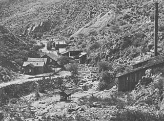
Duquesne is a ghost town in the Patagonia Mountains in eastern Santa Cruz County, Arizona, near the international border with Sonora, Mexico. The town, which is currently under private ownership and closed to the public although the roads are almost all public, was once the headquarters of the Duquesne Mining and Reduction Company and is the site of the Bonanza Mine. Washington Camp is approximately one mile northwest of Duquesne and was where the mine's reduction plant was located.
References
- ↑ Sherman, James E.; Barbara H. Sherman (1969). "Allen". Ghost Towns of Arizona (First ed.). University of Oklahoma Press. p. 10. ISBN 0-8061-0843-6.
- ↑ Cram, George Franklin (1890). Cram's Universal Atlas: Geographical, Astronomical and Historical, Containing a Complete Series of Maps of Modern Geography, Illustrated by Numerous Views and Charts; the Whole Supplemented with Valuable Statistics, Diagrams, and a Complete Gazetteer of the United States. G.F. Cram. p. 349.
