
Denver is the central city of a conurbation region in the U.S. state of Colorado. The conurbation includes one continuous region consisting of the six central counties of Adams, Arapahoe, Broomfield, Denver, Douglas, and Jefferson. The Denver region is part of the Front Range Urban Corridor.
Ajo is an unincorporated community in Pima County, Arizona, United States. It is the closest community to Organ Pipe Cactus National Monument. The population was 3,304 at the 2010 census. Ajo is located on State Route 85 just 43 miles (69 km) from the Mexican border.

Casas Adobes is an unincorporated community and census-designated place (CDP) located in the northern metropolitan area of Tucson, Arizona. The population was 66,795 at the 2010 census. Casas Adobes is situated south and southwest of the town of Oro Valley, and west of the community of Catalina Foothills.
Catalina Foothills is an unincorporated community and census-designated place (CDP) located north of Tucson in Pima County, Arizona, United States. Situated in the southern foothills of the Santa Catalina Mountains, Catalina Foothills had a population of 50,796 at the 2010 census. Catalina Foothills is one of the most affluent communities in Arizona and in the U.S., with the 6th highest per capita income in Arizona, and the 14th highest per capita income in the U.S. of communities with a population of at least 50,000. The Catalina Foothills community includes some of Arizona's most expensive homes and land, and has the highest median property value. It also includes resorts, golf courses, and spas.

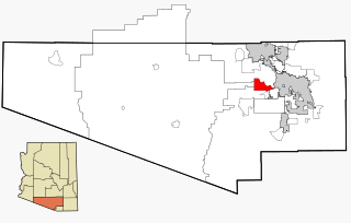
Corona de Tucson is a census-designated place (CDP) in Pima County, Arizona, United States. The population was 5,675 at the 2010 census, an increase of 598% from the 2000 population of 813.
Drexel Heights is an unincorporated community and census-designated place (CDP) in Pima County, Arizona, United States. The population was 27,749 at the 2010 census.

Flowing Wells is a census-designated place (CDP) in Pima County, Arizona, United States. It is a suburb of Tucson. The population was 16,419 at the 2010 census.

Littletown was a census-designated place (CDP) in Pima County, Arizona, United States. The population was 1,010 at the 2000 census. The area was annexed into Tucson in 2017.

Three Points is a census-designated place (CDP) in Pima County, Arizona, United States. The population was 5,581 at the 2010 census.
Tucson Estates is a census-designated place (CDP) in Pima County, Arizona, United States. The population was 9,755 at the 2000 census.

Vail is a census-designated place (CDP) in Pima County, Arizona, United States. It is 24 miles (39 km) southeast of Tucson. The population was 10,208 at the 2010 census, up from 2484 in the 2000 census. The area is known for the nearby Colossal Cave, a large cave system, and the Rincon Mountains District of Saguaro National Park, a top tourism spot within Arizona.

Oracle is a census-designated place (CDP) in Pinal County, Arizona, United States. The population was 3,686 at the 2010 census.
Greer is an unincorporated community and census-designated place in Apache County, Arizona, United States. It lies at an elevation of approximately 8,300 feet (2,500 m) in the White Mountains of Arizona, and is surrounded by the Apache-Sitgreaves National Forest. As of the 2010 census it had a population of 41. Greer was founded circa 1879 by Mormon settlers from Utah. The Greer post office has the ZIP code of 85927.

Summerhaven is a small unincorporated community and census-designated place (CDP) on Mount Lemmon in the Santa Catalina Mountains north of Tucson in Pima County, Arizona, United States. As of the 2010 census it had a permanent population of 40. Summerhaven sits at an elevation of approximately 7,600 to 8,200 feet above sea level. Summerhaven is accessed via the Catalina Highway from suburban northeast Tucson, and it is about 24.5 miles (39.4 km) from the base of the mountains to Summerhaven.

Komatke is a census-designated place in Maricopa County, Arizona, United States. The area currently comprising the CDP had a population of 821 at the 2010 census. It is located within the Gila River Indian Community. Its name refers to the Sierra Estrella mountain range. Komatke is located at the base of the mountain range.
Nelson is a census-designated place (CDP) in Pima County, Arizona, United States. The population was 259 at the 2010 census.
J-Six Ranchettes is an unincorporated community and census-designated place (CDP) in Pima County, Arizona, United States. It is bordered to the east by Cochise County and is located along Interstate 10, 9 miles (14 km) west of Benson and 38 miles (61 km) southeast of Tucson. It was first listed as a CDP prior to the 2020 census.
Kleindale is a census-designated place (CDP) in Pima County, Arizona, United States. It is bordered to the south, east, and west by the city of Tucson and to the north, across the Rillito River, by unincorporated Catalina Foothills. Kleindale was first listed as a CDP prior to the 2020 census.


