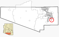
Corona de Tucson, Arizona

Last updated

Corona de Tucson, Arizona
CDP
Corona de Tucson.jpg
Corona de Tucson and Santa Rita foothills
Pima County Incorporated and Unincorporated areas Corona de Tucson highlighted.svg
Location in Pima County and the state of Arizona
USA Arizona location map.svg
Red pog.svg
Corona de Tucson
Location within Arizona
Usa edcp location map.svg
Red pog.svg
Corona de Tucson
Location within the United States
Coordinates: 31°57′28″N110°46′2″W / 31.95778°N 110.76722°W / 31.95778; -110.76722
Country Flag of the United States (23px).png  United States
State Flag of Arizona.svg  Arizona
County Pima
Area
[1]
  Total7.68 sq mi (19.90 km2)
  Land7.68 sq mi (19.90 km2)
  Water0.00 sq mi (0.00 km2)
Elevation
3,281 ft (1,000 m)
Population
 (2020)
  Total9,240
  Density1,202.81/sq mi (464.39/km2)
Time zone UTC-7 (MST (no DST))
ZIP code
85641
Area code 520
FIPS code 04-16030
GNIS feature ID 37250
View of Sierrita Mountains and copper mines from Corona de Tucson Corona de Tucson, Sierrita view.jpg
View of Sierrita Mountains and copper mines from Corona de Tucson

Corona de Tucson is a census-designated place (CDP) in Pima County, Arizona, United States. The population was 9,240 at the 2020 census, an increase of 1036% from the 2000 population of 813.

Contents

ZIP code 85641 is shared by Corona de Tucson and Vail.

Geography

Corona de Tucson is located at 31°57′28″N110°46′2″W / 31.95778°N 110.76722°W / 31.95778; -110.76722 (31.957860, -110.767238), [2] in the foothills of the Santa Rita Mountains, and adjacent to the Coronado National Forest.

According to the United States Census Bureau, the CDP has a total area of 2.6 square miles (6.7 km2), all land.

Demographics

Historical population
CensusPop.Note
2020 9,240
U.S. Decennial Census [3]

The 2020 census [4] counted a population of 9,240 people, across 2,789 households, of whom 98% had graduated high school and 45.7% had achieved a Bachelor's degree or higher. The median household income of Corona de Tucson residents was reported at $96,396 with 2.9% of population measured to be living in poverty.

As of the census [5] of 2010, there were 5,675 people, 2,165 households, and 280 families in the CDP. The population density was 932.2 inhabitants per square mile (359.9/km2). There were 395 housing units at an average density of 154.1 per square mile (59.5/km2). The racial makeup of the CDP was 85.8% White, 5.3% Black or African American, 0.5% Native American, 0.6% Asian, 3.2% from other races, and 4.6% from two or more races. 24.9% of the population were Hispanic or Latino of any race.

At the 2000 census, of the 813 households 17.8% had children under the age of 18 living with them, 68.1% were married couples living together, 4.3% had a female householder with no husband present, and 25.3% were non-families. 21.3% of households were one person and 8.5% were one person aged 65 or older. The average household size was 2.16 and the average family size was 2.48. [6] The age distribution was 13.9% under the age of 18, 4.1% from 18 to 24, 19.4% from 25 to 44, 38.6% from 45 to 64, and 24.0% 65 or older. The median age was 51 years. For every 100 females, there were 91.7 males. For every 100 females age 18 and over, there were 91.8 males. The median household income was $93,542, and the median family income was $61,375. Males had a median income of $49,722 versus $31,250 for females. The per capita income for the CDP was $28,304. None of the families and 1.0% of the population were living below the poverty line, including no under eighteens and none of those over 64.

Education

The entire CDP is served by the Vail Unified School District and the Pima County Joint Technical Education District’s 4th Governing Board District.

Public Safety

Corona de Tucson is patrolled by the 1st Beat of the Pima County Sheriff's Department's Rincon District and fire protection is provided by the Corona de Tucson Fire District.

See also

Related Research Articles

<span class="mw-page-title-main">Pima County, Arizona</span> County in Arizona, United States

Pima County is a county in the south central region of the U.S. state of Arizona. As of the 2020 census, the population was 1,043,433, making it Arizona's second-most populous county. The county seat is Tucson, where most of the population is centered. The county is named after the Pima Native Americans, also known as Tohono O'odham, who are indigenous to this area.

<span class="mw-page-title-main">Santa Cruz County, Arizona</span> County in Arizona, United States

Santa Cruz is a county in southern Arizona, United States. As of the 2020 census, the population is 47,669. The county seat is Nogales. The county was established in 1899. It borders Pima County to the north and west, Cochise County to the east, and the Mexican state of Sonora to the south.

<span class="mw-page-title-main">Claypool, Arizona</span> CDP in Gila County, Arizona

Claypool is a census-designated place (CDP) in Gila County, Arizona, United States. The population was 1,538 at the 2010 census, down from 1,794 at the 2000 census. It was named after W. D. Claypool, a member of both the State House of Representatives and State Senate in the 1910s and 1920s.

<span class="mw-page-title-main">Ajo, Arizona</span> Community in Pima County, Arizona

Ajo is an unincorporated community in Pima County, Arizona, United States. It is the closest community to Organ Pipe Cactus National Monument. The population was 3,039 at the 2020 census. Ajo is located on State Route 85 just 43 miles (69 km) from the Mexican border.

<span class="mw-page-title-main">Avra Valley, Arizona</span> CDP in Pima County, Arizona

Avra Valley is a census-designated place (CDP) in Pima County, Arizona, United States. The population was 6,050 at the 2010 census, up from 5,038 in 2000.

<span class="mw-page-title-main">Catalina, Arizona</span> CDP in Pima County, Arizona

Catalina is a census-designated place (CDP) in Pima County, Arizona, United States. The population was 7,025 at the 2000 census. Catalina continues to experience increasing population growth, while attempting to maintain its rural character. Catalina remains an unincorporated community, with no plans for annexation into any nearby towns.

<span class="mw-page-title-main">Catalina Foothills, Arizona</span> CDP in Pima County, Arizona

Catalina Foothills is an unincorporated community and census-designated place (CDP) located north of Tucson in Pima County, Arizona, United States. Situated in the southern foothills of the Santa Catalina Mountains, Catalina Foothills had a population of 50,796 at the 2010 census. Catalina Foothills is one of the most affluent communities in Arizona and in the U.S., with the 6th highest per capita income in Arizona, and the 14th highest per capita income in the U.S. of communities with a population of at least 50,000. The Catalina Foothills community includes some of Arizona's most expensive homes and land, and has the highest median property value. It also includes resorts, golf courses, and spas.

<span class="mw-page-title-main">Drexel-Alvernon, Arizona</span> CDP in Pima County, Arizona

Drexel-Alvernon was a census-designated place (CDP) in Pima County, Arizona, United States. The population was 4,192 at the 2000 census.

<span class="mw-page-title-main">East Sahuarita, Arizona</span> Community in Pima County, Arizona

East Sahuarita was a census-designated place (CDP) in Pima County, Arizona, United States. The population was 1,419 at the 2000 census. The CDP comprises the unincorporated neighborhoods east of incorporated Sahuarita.

<span class="mw-page-title-main">Flowing Wells, Arizona</span> CDP in Pima County, Arizona

Flowing Wells is a census-designated place (CDP) in Pima County, Arizona, United States. It is a suburb of Tucson. The population was 16,419 at the 2010 census.

<span class="mw-page-title-main">Green Valley, Arizona</span> CDP in Pima County, Arizona

Green Valley is an unincorporated community and census-designated place (CDP) in Pima County, Arizona, United States. The population was 22,616 at the 2020 census.

<span class="mw-page-title-main">Littletown, Arizona</span> CDP in Pima County, Arizona

Littletown was a census-designated place (CDP) in Pima County, Arizona, United States. The population was 1,010 at the 2000 census. The area was annexed into Tucson in 2017.

<span class="mw-page-title-main">Picture Rocks, Arizona</span> CDP in Pima County, Arizona

Picture Rocks is a census-designated place (CDP) in Pima County, Arizona, United States, home of the Tucson artifacts. The population was 9,551 at the 2020 United States census.

<span class="mw-page-title-main">South Tucson, Arizona</span> City in Arizona, United States

South Tucson is a city in Pima County, Arizona, United States and an enclave of the much larger city of Tucson. South Tucson is known for being heavily influenced by Hispanic, and especially Mexican, culture; restaurants and shops which sell traditional Mexican food and other goods can be found throughout the city. According to the 2010 census, the population of the city is 5,652.

<span class="mw-page-title-main">Tanque Verde, Arizona</span> CDP in Pima County, Arizona

Tanque Verde is a suburban unincorporated community in Pima County, Arizona, United States, northeast of Tucson. The population was 16,195 at the 2000 census. For statistical purposes, the United States Census Bureau has defined Tanque Verde as a census-designated place (CDP).

<span class="mw-page-title-main">Three Points, Arizona</span> CDP in Arizona, United States

Three Points is a census-designated place (CDP) in Pima County, Arizona, United States. The population was 5,581 at the 2010 census.

<span class="mw-page-title-main">Tucson Estates, Arizona</span> CDP in Arizona, United States

Tucson Estates is a census-designated place (CDP) in Pima County, Arizona, United States. The population was 9,755 at the 2000 census.

<span class="mw-page-title-main">Vail, Arizona</span> CDP in Pima County, Arizona

Vail is a census-designated place (CDP) in Pima County, Arizona, United States. It is 24 miles (39 km) southeast of Tucson. The population was 10,208 at the 2010 census, up from 2484 in the 2000 census. The area is known for the nearby Colossal Cave, a large cave system, and the Rincon Mountains District of Saguaro National Park, a top tourism spot within Arizona.

<span class="mw-page-title-main">Dudleyville, Arizona</span> CDP in Pinal County, Arizona

Dudleyville is a census-designated place (CDP) in Pinal County, Arizona, United States. The population was 959 at the 2010 census.

<span class="mw-page-title-main">Hawaiian Ocean View, Hawaii</span> Census-designated place in Hawaii, United States

Hawaiian Ocean View is a census-designated place (CDP) in Hawaiʻi County, Hawaiʻi, United States located in the District of Kaʻū. It includes the subdivisions of Hawaiian Ocean View Estates (HOVE), Hawaiian Ocean View Ranchos, Kahuku Country Gardens, Kula Kai View Estates, Kona Gardens, Keone's Ranchos, and Kona View Estates. The population was 4,437 at the 2010 census, up from 2,178 at the 2000 census.

References

  1. "2020 U.S. Gazetteer Files". United States Census Bureau. Retrieved October 29, 2021.
  2. "US Gazetteer files: 2010, 2000, and 1990". United States Census Bureau. February 12, 2011. Retrieved April 23, 2011.
  3. "Census of Population and Housing". Census.gov. Retrieved June 4, 2016.
  4. Census.gov. "U.S. Census Bureau Quick Facts Corona De Tucson, Arizona" . Retrieved July 26, 2022.
  5. Bureau, US Census. "Search Results". The United States Census Bureau. Retrieved March 30, 2020.
  6. "U.S. Census website". United States Census Bureau . Retrieved January 31, 2008.